Yerington, Nevada
| Yerington, Nevada | |
|---|---|
| City | |
|
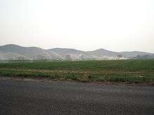
Main Street (SR 208) in downtown Yerington | |
| Motto: "Preserving Our History While Planning Our Future" | |
 Location of Yerington, Nevada | |
 Yerington, Nevada Location in the United States | |
| Coordinates: 38°59′7″N 119°9′55″W / 38.98528°N 119.16528°W | |
| Country | United States |
| State | Nevada |
| County | Lyon |
| Government | |
| • Mayor |
George Dini [1] |
| Area | |
| • Total | 8.6 sq mi (22.3 km2) |
| • Land | 8.6 sq mi (22.3 km2) |
| • Water | 0.0 sq mi (0.0 km2) |
| Elevation | 4,390 ft (1,338 m) |
| Population (2010) | |
| • Total | 3,048 |
| • Density | 350/sq mi (140/km2) |
| Time zone | Pacific (PST) (UTC-8) |
| • Summer (DST) | PDT (UTC-7) |
| ZIP code | 89447 |
| Area code(s) | 775 |
| FIPS code | 32-85400 |
| GNIS feature ID | 0848686 |
| Website |
www |
_near_Littell_Street_in_downtown_Yerington%2C_Nevada.jpg)
Yerington is a city in Lyon County, Nevada, United States. The population was 3,048 at the 2010 census.[2] It is named after Henry M. Yerington, Superintendent of the Virginia and Truckee Railroad from 1868 to 1910. It is the current county seat of Lyon County, the first county seat being established at Dayton, Nevada on November 29, 1861.[3] After the Dayton Court House burned down in 1909, the seat was moved to Yerington in 1911.
Geography
Yerington is located at the intersection of US 95A and Nevada State Route 208. According to the United States Census Bureau, the city has a total area of 8.6 square miles (22.3 km2), all land.[2]
Demographics
| Historical population | |||
|---|---|---|---|
| Census | Pop. | %± | |
| 1900 | 682 | — | |
| 1910 | 1,169 | 71.4% | |
| 1920 | 1,005 | −14.0% | |
| 1930 | 964 | −4.1% | |
| 1940 | 1,157 | 20.0% | |
| 1950 | 1,764 | 52.5% | |
| 1960 | 2,010 | 13.9% | |
| 1970 | 2,021 | 0.5% | |
| 1980 | 2,367 | 17.1% | |
| 1990 | 2,883 | 21.8% | |
| 2000 | 3,048 | 5.7% | |
| 2010 | 3,048 | 0.0% | |
| Est. 2015 | 3,064 | [4] | 0.5% |
As of the census[6] of 2000, there were 2,883 people, 1,203 households, and 729 families residing in the city. The population density was 1,698.4 people per square mile (654.8/km²). There were 1,359 housing units at an average density of 800.6 per square mile (308.7/km²). The racial makeup of the city was 84.53% White, 0.17% African American, 6.24% Native American, 0.38% Asian, 5.79% from other races, and 2.88% from two or more races. Hispanic or Latino of any race were 15.44% of the population.
There were 1,203 households out of which 27.7% had children under the age of 18 living with them, 46.1% were married couples living together, 10.2% had a female householder with no husband present, and 39.4% were non-families. 35.0% of all households were made up of individuals, and 19.6% had someone living alone who was 65 years of age or older. The average household size was 2.29, and the average family size was 2.97.
In the city the population was spread out with 24.7% under the age of 18, 8.1% from 18 to 24, 22.2% from 25 to 44, 19.4% from 45 to 64, and 25.7% who were 65 years of age or older. The median age was 41 years. For every 100 females there were 99.1 males. For every 100 females age 18 and over, there were 92.7 males.
The median income for a household in the city was $31,151, and the median income for a family was $39,038. Males had a median income of $25,724 versus $24,550 for females. The per capita income for the city was $18,640. About 12.6% of families and 17.9% of the population were below the poverty line, including 26.2% of those under age 18 and 12.3% of those age 65 or over.
Politics
The Yerington Paiute Tribe of the Yerington Colony and Campbell Ranch is headquartered in Yerington.[7]
Notable residents
- Nevada Barr, writer
- Jesse Brinkley, professional boxer, contestant on season one of The Contender
- Joe Dini, longtime member of the Nevada Assembly
Wilson Ranch fire balloon
During World War II, one of many Japanese fire balloons launched at the United States landed on the Wilson Ranch near Yerington.[8] The ranchers, not knowing what it was, attempted to notify the authorities by mail, but did not receive a response until after they cut it up and used it as a hay tarp.[9]
In popular culture
"Darcy Farrow," a folk song written by Steve Gillette and Tom Campbell, mentions Yerington ("Her eyes shone bright like the pretty lights / That shine in the night out of Yerington town," 7-8) and other places and landmarks in the area, including Virginia City, the Carson Valley, and the Truckee River. Critics have noted the geographical inaccuracy in the line "The Walker runs down to the Carson Valley plain."[10]
John Denver's version of "Darcy Farrow" sold more than 4 million copies.[11]
Climate
Yerington experiences a desert climate and has a Köppen Climate Classification of Bwk.[12]
| Climate data for Yerington, Nevada | |||||||||||||
|---|---|---|---|---|---|---|---|---|---|---|---|---|---|
| Month | Jan | Feb | Mar | Apr | May | Jun | Jul | Aug | Sep | Oct | Nov | Dec | Year |
| Average high °C (°F) | 8 (46) |
11 (52) |
16 (60) |
20 (68) |
23 (74) |
28 (83) |
33 (92) |
32 (90) |
28 (82) |
22 (71) |
14 (58) |
9 (48) |
21 (69) |
| Average low °C (°F) | −9 (15) |
−6 (21) |
−4 (25) |
−1 (31) |
3 (38) |
7 (44) |
9 (49) |
8 (47) |
4 (39) |
−1 (30) |
−6 (21) |
−9 (16) |
−1 (31) |
| Average precipitation mm (inches) | 15 (0.6) |
15 (0.6) |
10 (0.4) |
10 (0.4) |
13 (0.5) |
10 (0.4) |
5 (0.2) |
5 (0.2) |
8 (0.3) |
8 (0.3) |
10 (0.4) |
13 (0.5) |
122 (4.8) |
| Source: Weatherbase [13] | |||||||||||||
References
- ↑ "City of Yerington Website". Retrieved 25 November 2011.
- 1 2 "Geographic Identifiers: 2010 Demographic Profile Data (G001): Yerington city, Nevada". U.S. Census Bureau, American Factfinder. Retrieved January 25, 2013.
- ↑ Laws of the Territory of Nevada passed at the first regular session of the Legislative Assembly. San Francisco, CA: Valentine & Co. 1862. pp. 289–291. Retrieved May 14, 2014.
- ↑ "Annual Estimates of the Resident Population for Incorporated Places: April 1, 2010 to July 1, 2015". Retrieved July 2, 2016.
- ↑ "Census of Population and Housing". Census.gov. Retrieved June 4, 2015.
- ↑ "American FactFinder". United States Census Bureau. Retrieved 2008-01-31.
- ↑ Conway, Lorna. "Tribal Government." Yerington Paiute Tribe]. 2007 (retrieved 12 December 2008)
- ↑ "Japanese Balloons and Attached Devices, TAIC Report, Number 41, May 1945". Retrieved 2015-02-07.
- ↑ Schindler, Hal (1995-05-05). "Utah Was Spared Damage By Japan's Floating Weapons". The Salt Lake Tribune. Retrieved 2015-02-07.
- ↑ Gillette, Steve. "Darcy Farrow Lyrics". Steve Gillette & Cindy Mangsen website. Retrieved 2013-02-08.
- ↑ Steele-Carlin, Sherril (2001-10-14). "Darcy Farrow, NV". American Profile. Archived from the original on 2008-12-09. Retrieved 2016-04-27.
- ↑ Climate Summary for Yerington, Nevada
- ↑ "Weatherbase.com". Weatherbase. 2013. Retrieved on September 8, 2013.
External links
| Wikimedia Commons has media related to Yerington, Nevada. |
Municipalities and communities of Lyon County, Nevada, United States | ||
|---|---|---|
| Cities | 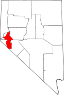 | |
| CDPs | ||
| Other unincorporated communities | ||
| Ghost towns | ||
| Indian reservation | ||