Yeadon, West Yorkshire
| Yeadon | |
 Yeadon High Street |
|
 Yeadon |
|
| Population | 22,233 (Ward. Otley and Yeadon. 2011) |
|---|---|
| OS grid reference | SE219398 |
| – London | 205mi |
| Metropolitan borough | City of Leeds |
| Metropolitan county | West Yorkshire |
| Region | Yorkshire and the Humber |
| Country | England |
| Sovereign state | United Kingdom |
| Post town | LEEDS |
| Postcode district | LS19 |
| Dialling code | 0113 |
| Police | West Yorkshire |
| Fire | West Yorkshire |
| Ambulance | Yorkshire |
| EU Parliament | Yorkshire and the Humber |
| UK Parliament | Leeds North West, Pudsey, |
Coordinates: 53°52′08″N 1°41′17″W / 53.869°N 1.688°W
Yeadon is a town within the City of Leeds metropolitan borough, in West Yorkshire, England. It is home to Leeds Bradford International Airport. The appropriate City of Leeds ward is called Otley and Yeadon. The population at the 2011 Census was 22,233.[1]
History
At the time of the Anglo-Saxons in the early 7th century AD much of the Aire valley was still heavily wooded, although perhaps Yeadon stood out above the tree line. The place name is probably derived from two Old English words meaning "high hill", as -don is derived from an Anglo-Saxon word for hill.
Between 675 and 725 AD there was a Christian settlement in Airedale and other Norse settlements followed. Viking settlers called the highest point in the area Yeadon Haw. The suffix haw appears to have been tautological, as it was likely derived from the Old Norse haugr, which also means "hill".[2] When the Domesday Book was compiled, Rawdon, Horsforth and Yeadon were classified as Terra Regis – land owned by the king.
Historically a part of the West Riding of Yorkshire, Yeadon was a clothing and mill town in the 19th century. It had a cattle fair every year on the first Monday in April and the Yeadon Feast in the third week of August, which was held on Albert Square at the top of the High Street. The fair continued until the early 1980s, when housing for the elderly was built on the site.
The former Yorkshire and England cricket captain Brian Close lived in the town during his childhood.
In chronostratigraphy, the term Yeadonian – for a British sub-stage of the Carboniferous period – is derived from the study of a geological site at the brick and tile works in Yeadon.[3]
Public transport
Yeadon had a rail connection, but the line is now a nature path and most of its length can still be walked, from the Old Engine Fields, off Henshaw Lane down Guiseley retail park where it joined the Guiseley Branch Line. The line continued over Henshaw Lane where an old bridge can still be seen, immediately after the bridge was the railway station, near the Station Inn in the (now) council storage yard. The line terminated opposite Trinity Church (previously Benton Congregational Church) in Rawdon. Yeadon Station was mostly used for goods and served several large mills directly along its route (Leafield Mill, Kirk Lane Mill, Westfield Mill, Green Lane Mill, a soap works and a dye works). The only passenger trains were special services. The first train to leave Yeadon Station held 500 people in 1905. The following year, trains took passengers from Yeadon to Blackpool. The line was closed in 1966. Yeadon (Green Lane) was connected by tram to Leeds from 1909 until the 1950s. Yeadon has a bus connection to Leeds, Bradford, Harrogate and The Airport. The local services are operated by First Leeds, Yorkshire Tiger and TLC Travel. Most school services are operated by CT Plus with some operated by Transdev Blazefield. The nearest open railway station is Guiseley.
Avro had a factory next to Yeadon Aerodrome from 1938 to 1946 which produced many of the company's wartime planes, including the Lancaster, Lincoln, York and Anson. Approximately 700 Lancasters were produced at Yeadon. The town retains links with Leeds Bradford International Airport, with a considerable percentage of the local population employed there. Aviation heritage in Yeadon is kept alive by the activities of 2168 (Yeadon) Squadron Air Training Corps.[4]
Church
Yeadon was part of the old, large Guiseley Parish but a church, St. John the Evangelist, was built in 1844.[5]
Landmarks

Yeadon is northwest of Leeds, at one of the highest points of the city, making it an unusual location for an airport. Yeadon Tarn (also known as Yeadon Dam) is located between High Street and the airport runway. During the Second World War it was drained to prevent enemy aircraft using its reflection as a landmark to identify the nearby Avro factory.[6] The tarn is used for sailing and fishing. Mallard ducks, swans and a sizable population of Canada geese can be found at the tarn. There is a BMX bike track adjacent to it, with competitions held in the summer.
The national charity Epilepsy Action has its headquarters in the town.
Governance
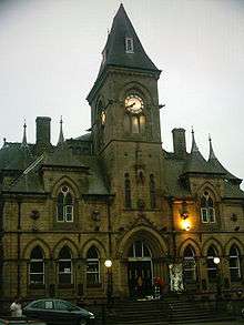
Yeadon, along with neighbouring towns Guiseley and Rawdon, formed Aireborough Urban District, which was created in 1937 and abolished in 1974. Yeadon still hosts local Rugby Union side Aireborough RUFC at Nunroyd Park.[7] Yeadon (except for the area north of Swincar Avenue on Kirk Lane, and the area south of the A65) is now in the Leeds City Council Ward of Otley & Yeadon. It is represented by three Liberal Democrat Councillors, Ryk Downes, Colin Campbell and Sandy Lay. Leeds City Council now have control of public services in Yeadon. Yeadon falls into two constituencies; the majority is in Leeds North West, which is held by the Liberal Democrats, represented by Greg Mulholland, and some falls into Pudsey, which is held by the Conservative Party, represented by Stuart Andrew. Yeadon Town Hall, the main civic building in the town, is known for its distinctive clock tower. The building was used as a registrar's office in the Yorkshire Television programme, The Beiderbecke Tapes.
Amenities
Yeadon has a developed town centre and most of the businesses are situated around the High Street. There is a Morrisons supermarket as well as several other chains of shops, such as KC's Express (est. 1994). There are also building societies, estate agents and public houses. There are also both Travelodge and Premier Travel Inn hotels situated near the airport.
Sports
The origins of cricket in Yeadon are not really known, but around 1850 scores of people played on Yeadon Moor when work ended on a Saturday teatime. Play continued as long as the light would allow.
At that time Yeadon boasted two teams, Topenders and Lowenders. The two teams decided to amalgamate at a meeting held in the Old Victoria Hotel, at the junction of Sandy Way and the Green, in 1859. The newly amalgamated club adopted the name Yeadon United Cricket Club, ‘united’ being dropped some time later.
The legendary W. G. Grace played at the Swan ground in 1877 with a United South XI. Grace was bowled for nought by an elated bowler who was then admonished by his captain for removing the man the crowd had paid to see.
Economy
_003.jpg)
The airline, Jet2.com, has its head office at Leeds Bradford Airport,[8] as does Dart Group, Jet2.com's parent company.[9]
Location grid
 |
Otley | | ||
| Guiseley | |
Bramhope | ||
| ||||
| | ||||
| Rawdon | Horsforth |
References
- ↑ "City of Leeds ward population 2011". Neighbourhood Statistics. Office for National Statistics. Retrieved 28 February 2016.
- ↑ Yeadon Local History (Education and Outreach Coordinator, West Yorkshire Archaeology Service. November 2009)
- ↑ Cleal, C.J., Thomas, B.A., 1996 British Upper Carboniferous Stratigraphy Vol 11 of the Geological Conservation Review series
- ↑ "2168 (Yeadon) Squadron - Air Training Corps - Home of the Merlins". www.2168atc.org. Retrieved 22 July 2008.
- ↑ http://www.stjohnsyeadon.org/#/history-part-1/4532813885
- ↑ "BBC - WW2 People's War - Life in Old Bramhope in Wartime - Part 1". BBC. Retrieved 22 July 2008.
- ↑ "ARUFC - CLub Contacts". www.aireboroughrufc.org. Archived from the original on 2 February 2004. Retrieved 22 July 2008.
- ↑ "Jet2.com builds on its foundations at Leeds Bradford - literally!" Jet2.com. 6 February 2006. Retrieved on 19 June 2010.
- ↑ "Contacts." Dart Group. Retrieved on 31 December 2011. "Registered Office Dart Group PLC Low Fare Finder House Leeds Bradford International Airport Leeds LS19 7TU United Kingdom"
External links
| Wikimedia Commons has media related to Yeadon, West Yorkshire. |
- The Yeadon Lockout and Hunger Marches are a little-known aspect of Yeadon's industrial heritage.
- "The Ancient Parish of Guiseley". GENUKI. Retrieved 29 October 2007. Yeadon was in this parish