Yarmouk River
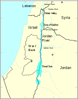
The Yarmuk River (Arabic: نهر اليرموك, Nahr Al-Yarmuk, or شريعة المناذرة, Shariat el Menadhirah; Hebrew: נהר הירמוך, Nahar HaYarmukh; Latin: Hieromices),[1][2] sometimes spelled Yarmouk, is the largest tributary of the Jordan River.[3] It runs in Jordan, Syria, and Israel and drains much of the Hauran plateau. Its main tributaries are the wadis of 'Allan and Ruqqad from the north, Ehreir and Zeizun from the east. Although it is narrow and shallow throughout its course, at its mouth it is nearly as wide as the Jordan, measuring thirty feet in breadth and five in depth. The once celebrated Matthew Bridge used to cross the Yarmuk at its confluence with the Jordan.[4]
History
Prehistory
The Yarmukian Culture is a Pottery Neolithic culture that inhabited parts of Palestine and Jordan. Its type site is at Sha'ar HaGolan, on the river mouth. Early Bronze Age I is represented in the Golan only in the area of the river.[5]
Ancient
Yarmuk forms a natural border between the plains to the north - Hauran, Bashan and Golan - and the Gilead mountains to the south. Thus it has often served as boundary line between political entities. The Aramean kingdoms and the Kingdom of Israel (Samaria), of the Hebrew bible, might have settled this way occasionally. Under the Assyrian and Persian empires the province of Ashteroth Karnaim laid to the north, and that of Gal'azu (Gilead) to the south. In Hellenistic times, the territory of Hippos was across from those of Gadara and Abila (Abel) on the south, while Dion sat on the eastern tributaries. Abila (Tel Abil) is attested in the 14th-century BC Amarna Letters. This is possibly the case also for Geshur, assumed to have laid north of the river.[6] Other historical cities on the course of the river are Dara'a, Heet, Jalin; and the archaeological sites of Tell Shihab and Khirbet ed-Duweir (See Lo-debar).[6]
The Battle of Yarmouk, where Muslim forces defeated those of the Byzantine Empire and gained control of Syria, took place north of the river in 636.
Modern
Today the lower part of the river, close to the Jordan Valley, forms part of the border between Israel and Jordan. Further upstream it forms part of the border between Syria and Jordan (a border largely inherited from the 1923 Franco-British Boundary Agreement). The area of Al-Hamma, or Hamat Gader in the valley is held by Israel but claimed by Syria.
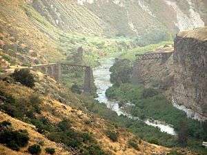
A fork of the Hejaz Railway (connecting to the Jezreel Valley railway in Samakh) ran in the river valley from 1905 to 1946.[7] It was deprecated after being bombed by the Jewish Haganah in the Night of the Bridges on 16 June 1946. The hydroplant of Naharayim, on the junction with Jordan River, served Mandatory Palestine from 1932 to 1948. The Al-Wehda Dam was constructed in Jordan and Syria in the 2000s.
References and external links
| Wikimedia Commons has media related to Yarmouk River. |
- ↑ Schürer, Emil (2014-01-30). The History of the Jewish People in the Age of Jesus Christ. A&C Black. page 133, note 243. ISBN 9781472558299.
- ↑ The Greek is sometimes given as Ancient Greek: Ἱερομύαξ, Hieromyax, or Ancient Greek: Ιερμουχάς,Iermouchas.
- ↑ It is one of three main tributaries which enter the Jordan between the Sea of Galilee and the Dead Sea; to the south are the Zarqa and the Mujib (Arnon) rivers.
- ↑ 1906 Jewish Encyclopedia
- ↑ Ma'oz, Zvi Uri (1997). "Golan". The Oxford Encyclopedia of Archaeology in the Near East. ISBN 0195112156. p. 418.
- 1 2 Ma'oz, p. 420
- ↑ Yarmuk River railway bridges, 1933 aerial photographs. Aerial Photographic Archive for Archaeology in the Middle East / National Archives, London.
 This article incorporates text from a publication now in the public domain: Singer, Isidore; et al., eds. (1901–1906). "YARMUK (modern Shari'at al-Manaḍirah)". Jewish Encyclopedia. New York: Funk & Wagnalls Company.
Coordinates: 32°38′52″N 35°33′51″E / 32.64778°N 35.56417°E