Yaren District
| Yaren | |
|---|---|
| District | |
|
Nauru parliament | |
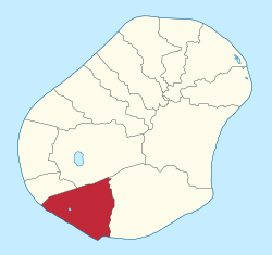 Yaren District within Nauru | |
| Coordinates: NR 0°32′51.72″S 166°55′15.12″E / 0.5477000°S 166.9208667°ECoordinates: NR 0°32′51.72″S 166°55′15.12″E / 0.5477000°S 166.9208667°E | |
| Country |
|
| Constituency | Yaren |
| Area | |
| • Total | 1.5 km2 (0.6 sq mi) |
| Elevation | 25 m (82 ft) |
| Population (2011) | |
| • Total | 747 |
| Time zone | (UTC+12) |
| Area code(s) | +674 |
| Climate | Af |


Yaren, in earlier times Makwa/Moqua, is a district of the Pacific nation of Nauru. It is the de facto capital of Nauru and is coextensive with Yaren Constituency.[1]
History
The district was created in 1968. Its original name, Makwa (or Moqua), refers to Moqua Well, an underground lake and primary source of drinking water for Nauruan people.[2]
Geography
Yaren is located in the south of the island. Its area is 1.5 km2 (0.58 sq mi), and its elevation was 25 metres (82 feet) as of 2007. To the north of Yaren is Buada, to the east is Meneng and to the west is Boe.[3]
Administration
Yaren (and sometimes Aiwo) is usually listed as the capital of Nauru though this is incorrect; the republic does not have cities or an official capital. Yaren is accepted by the United Nations as the "main district".
English and Nauruan, the official languages of Nauru, are spoken in the district.
Government and administrative buildings
The following government offices are located in this district:
- the Parliament House
- the earth station
- the administration offices
- the police station
- the fire station
- the National Stadium
- the Australian High Commission and Taiwanese Embassy
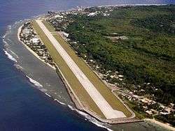
- the Nauru International Airport, air terminal, and head office of Nauru Airlines
Constituency
Yaren also constitutes a political constituency. It returns two members to the Parliament of Nauru.[1]
Main sights
- The Moqua Well is situated in Yaren.
Personalities
- Kieren Keke (b. 1971), politician and medical doctor
- Charmaine Scotty, politician
- Dominic Tabuna (b. 1980), politician
See also
References
- 1 2 Constituencies of Nauru (naurugov.nr)
- ↑ "Moqua Caves and Moqua Well", Gatis Pāvils, 30 October 2011.
- ↑ 313728509 Yaren on OpenStreetMap
External links
![]() Media related to Yaren at Wikimedia Commons
Media related to Yaren at Wikimedia Commons
Districts and Constituencies of Nauru | ||
|---|---|---|
| Districts | ||
| Constituencies | ||