Yanggu County, Gangwon
| Yanggu 양구군 | ||
|---|---|---|
| County | ||
| Korean transcription(s) | ||
| • Hangul | 양구군 | |
| • Hanja | 楊口郡 | |
| • Revised Romanization | Yanggu-gun | |
| • McCune-Reischauer | Yanggu-gun | |
| ||
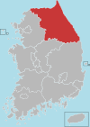
 Location in South Korea | ||
| Country |
| |
| Region | Gwandong | |
| Administrative divisions | 1 eup, 4 myeon | |
| Area | ||
| • Total | 700.8 km2 (270.6 sq mi) | |
| Population (2000) | ||
| • Total | 24,027 | |
| • Density | 34/km2 (90/sq mi) | |
| • Dialect | Gangwon | |

Yanggu County (Yanggu-gun) is a county in Gangwon Province, South Korea.
The northern part of Yanggu County was part of the front line for much of the Korean War, and now borders the Demilitarized Zone. Several Korean War battle sites are located in Yanggu County, including Bloody Ridge, Heartbreak Ridge, and Hill 1179 (Daeusan).
Yanggu is located the center of Korean peninsula. Dochon-ri village in Nam-myeon[1] in Yanggu is called "navel of Korea".[2]
Sister cities
References
- ↑ The Natural Side of the DMZ in Yanggu, Gangwon-do
- ↑ Travel to the nude in nature, “DMZ’s story 4 – Yanggu” 한반도의 배꼽, 양구
External links
Coordinates: 38°06′29″N 127°59′22″E / 38.107952°N 127.989507°E
This article is issued from Wikipedia - version of the 8/2/2016. The text is available under the Creative Commons Attribution/Share Alike but additional terms may apply for the media files.