Xilingol League
| Xilingol League 锡林郭勒盟 • ᠰᠢᠯᠢ ᠶᠢᠨ ᠭᠣᠣᠯ ᠠᠶᠢᠮᠠᠭ | |
|---|---|
| League | |
|
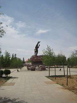
Dinosaur statue in Erenhot | |
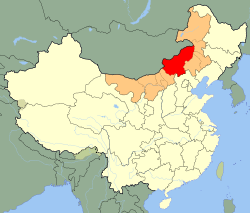 Xilingol (red) in Inner Mongolia (orange) and China | |
| Country | People's Republic of China |
| Region | Inner Mongolia |
| Area | |
| • Total | 211,866 km2 (81,802 sq mi) |
| Population (2010) | |
| • Total | 1,028,022 |
| • Density | 4.9/km2 (13/sq mi) |
| Time zone | China Standard (UTC+8) |
| Postal code | 152500 |
| Area code(s) | 0479 |
| Licence plate prefixes | 蒙H |
| Website | http://www.xlgl.gov.cn/ |
| Xilingol League | |||||||
| Chinese name | |||||||
|---|---|---|---|---|---|---|---|
| Traditional Chinese | 錫林郭勒 | ||||||
| Simplified Chinese | 锡林郭勒 | ||||||
| |||||||
| Mongolian name | |||||||
| Mongolian Cyrillic | Шилийн Гол аймаг | ||||||
| Mongolian script | ᠰᠢᠯᠢ ᠶᠢᠨ ᠭᠣᠣᠯ ᠠᠶᠢᠮᠠᠭ | ||||||
| |||||||
Xilingol, Xilin Gol or Xilinguole Aimag/League is one of 12 league of Inner Mongolia. The seat is Xilinhot, while the area is 202,580 km2 (78,220 sq mi). The league's economy is based on mining and agriculture.
Xilingol borders Mongolia to the north, Chifeng, Tongliao and Hinggan League to the east, Ulanqab to the west and Hebei to the south.
This is the only prefecture-level division of Inner Mongolia in whose south border nomadic culture is still vivid. Some division, such as Tongliao, has a much higher percentage of Mongolian population but agriculture is extensive among Khorchin Mongols there. Xilingol League is also the closest Inner Mongolian prefecture-level division to Beijing, although among those Inner Mongolian prefecture-level divisions bordering Hebei, the province surrounding Beijing, Xilin Gol is also the most unapproachable one. With a significant population of Chakhar Mongols, who speaks a Mongolian dialect closly related to the standard dialect of Mongolia, the dialect spoken in Xulun Hoh Banner, Xilin Gol League is chosen as the standard language of Mongolian in China, nevertheless the de facto common standard is a mix of Khorchin-Kharchin and Chakhar, due to an extensive Khorchin Mongolian speakers presence in China.
Demographics
In 2000, there were 975,168 inhabitants:
| Ethnic group | no. of inhabitants | share |
|---|---|---|
| Han | 651,174 | 66.78% |
| Mongols | 284,995 | 29.23% |
| Manchu | 26,687 | 2.74% |
| Hui | 11,009 | 1.13% |
| Daur | 784 | 0.08% |
| Other | 519 | 0.04% |
Administrative Subdivisions
Xilin Gol is divided into two county-level cities, one county and nine banners:
| Map | |||||||
|---|---|---|---|---|---|---|---|
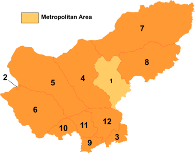 | |||||||
| # | Name | Mongolian | Hanzi | Hanyu Pinyin | Population (2010) | Area (km²) | Density (/km²) |
| 1 | Xilinhot (city) | ᠰᠢᠯᠢ ᠶᠢᠨ ᠬᠣᠲᠠ (Sili-yin qota) |
锡林浩特市 | Xīlínhàotè Shì | 245,886 | 15,758 | 10 |
| 2 | Erenhot (city) | ᠡᠷᠢᠶᠡᠨ ᠬᠣᠲᠠ (Eriyen qota) |
二连浩特市 | Èrliánhàotè Shì | 74,197 | 450 | 44 |
| 3 | Duolun County | ᠳᠣᠯᠣᠨᠨᠤᠤᠷ ᠰᠢᠶᠠᠨ (Dolonnuur siyan) |
多伦县 | Duōlún Xiàn | 100,893 | 3,773 | 27 |
| 4 | Abag Banner | ᠠᠪᠠᠭᠠ ᠬᠣᠰᠢᠭᠤ (Abaɣ-a qosiɣu) |
阿巴嘎旗 | Ābāgā Qí | 43,574 | 27,495 | 1 |
| 5 | Sonid Left Banner | ᠰᠥᠨᠡᠳ ᠵᠡᠭᠦᠨ ᠬᠣᠰᠢᠭᠤ (Söned Jegün qosiɣu) |
苏尼特左旗 | Sūnítè Zuǒ Qí | 33,652 | 33,469 | 1 |
| 6 | Sonid Right Banner | ᠰᠥᠨᠡᠳ ᠪᠠᠷᠠᠭᠤᠨ ᠬᠣᠰᠢᠭᠤ (Söned Baraɣun qosiɣu) |
苏尼特右旗 | Sūnítè Yòu Qí | 71,063 | 26,700 | 3 |
| 7 | East Ujimqin Banner | ᠵᠡᠭᠦᠨ ᠤᠵᠤᠮᠤᠴᠢᠨ ᠬᠣᠰᠢᠭᠤ ( Jegün Ujumučin qosiɣu) |
东乌珠穆沁旗 | Dōng Wūzhūmùqìn Qí | 93,962 | 47,554 | 1 |
| 8 | West Ujimqin Banner | ᠪᠠᠷᠠᠭᠤᠨ ᠤᠵᠤᠮᠤᠴᠢᠨ ᠬᠣᠰᠢᠭᠤ (Baraɣun Ujumučin qosiɣu) |
西乌珠穆沁旗 | Xī Wūzhūmùqìn Qí | 87,614 | 22,960 | 3 |
| 9 | Taibus Banner | ᠲᠠᠶᠢᠫᠤᠰᠧ ᠬᠣᠰᠢᠭᠤ (Tayipusė qosiɣu) |
太仆寺旗 | Tàipúsì Qí | 112,339 | 3,415 | 59 |
| 10 | Bordered Yellow Banner | ᠬᠥᠪᠡᠭᠡᠲᠦ ᠰᠢᠷᠠ ᠬᠣᠰᠢᠭᠤ (Köbegetü Sir-a qosiɣu) |
镶黄旗 | Xiānghuáng Qí | 28,450 | 4,960 | 6 |
| 11 | Plain and Bordered White Banner | ᠰᠢᠯᠤᠭᠤᠨ ᠬᠥᠪᠡᠭᠡᠲᠦ ᠴᠠᠭᠠᠨ ᠬᠣᠰᠢᠭᠤ (Siluɣun Köbegetü Čaɣan qosiɣu) |
正镶白旗 | Zhèngxiāngbái Qí | 54,443 | 6,083 | 12 |
| 12 | Plain Blue Banner | ᠰᠢᠯᠤᠭᠤᠨ ᠬᠥᠬᠡ ᠬᠣᠰᠢᠭᠤ (Siluɣun Köke qosiɣu) |
正蓝旗 | Zhènglán Qí | 81,967 | 9,963 | 8 |
Demonstrations in 2011
After the alleged murder of a Mongolian herder, Mergen, by a Chinese truck driver who was blocking the way for Chinese coal trucks to pass through his pasture on May 10, 2011. Protests with some thousand protestors broke out in Xilingol.[1] To prevent the spreading of protests, the Chinese government sealed off the Inner Mongolia University for Nationalities in Tongliao and the Nationalities University in Hohhot, the only two universities where lessons are predominantly taught in Mongolian. In addition, it enforced tight control on the internet and shut down QQ chatrooms.[2]
References
- ↑ Ben Blanchard and Sui-Lee Wee (Reuters), Friday, May 27, 2011: Parts of Inner Mongolia 'under martial law' as protests spread. E.g. at .
- ↑ http://www.smhric.org/news_383.htm
External links
 |
|
Hinggan League | | |
| |
|
Tongliao | ||
| ||||
| | ||||
| Ulanqab | Chengde and Zhangjiakou, Hebei | Chifeng |
Coordinates: 44°56′41″N 115°22′44″E / 44.9447°N 115.379°E