Wymbritseradiel
| Wymbritseradeel Wymbritseradiel | |||
|---|---|---|---|
| Former municipality | |||
|
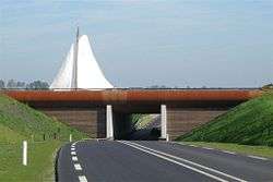
Aqueduct | |||
| |||
 | |||
| Coordinates: 53°1′N 5°37′E / 53.017°N 5.617°ECoordinates: 53°1′N 5°37′E / 53.017°N 5.617°E | |||
| Country | Netherlands | ||
| Province | Friesland | ||
| Municipality | Súdwest-Fryslân | ||
| Area(2006) | |||
| • Total | 162.74 km2 (62.83 sq mi) | ||
| • Land | 138.33 km2 (53.41 sq mi) | ||
| • Water | 24.41 km2 (9.42 sq mi) | ||
| Population (1 January 2007) | |||
| • Total | 16,136 | ||
| • Density | 117/km2 (300/sq mi) | ||
| Source: CBS, Statline. | |||
| Time zone | CET (UTC+1) | ||
| • Summer (DST) | CEST (UTC+2) | ||

Wymbritseradiel is a former municipality in the province of Friesland in the Netherlands. Its official name was in West Frisian, but the municipality was also known by its Dutch name Wymbritseradeel (![]() pronunciation ). In 2011, the municipality merged with the municipalities of Bolsward, Nijefurd, Sneek and Wûnseradiel to form Súdwest Fryslân.
pronunciation ). In 2011, the municipality merged with the municipalities of Bolsward, Nijefurd, Sneek and Wûnseradiel to form Súdwest Fryslân.
Population centres
Abbega, Blauwhuis, Folsgare, Gaastmeer, Gauw, Goënga, Greonterp, Heeg, Hommerts, Idzega, IJlst, Indijk, Jutrijp, Koufurdurrige, Nijland, Oosthem, Oppenhuizen, Oudega, Sandfirden, Scharnegoutum, Smallebrugge, Tirns, Tjalhuizum, Uitwellingerga, Westhem, Wolsum, Woudsend, Ypecolsga.
External links
![]() Media related to Wymbritseradeel at Wikimedia Commons
Media related to Wymbritseradeel at Wikimedia Commons
This article is issued from Wikipedia - version of the 7/20/2016. The text is available under the Creative Commons Attribution/Share Alike but additional terms may apply for the media files.