Wycombe Rural District
| Wycombe | |
|---|---|
| Area | |
| • 1911 | 71,716 acres (112.056 sq mi; 290.22 km2) |
| • 1931 | 64,357 acres (100.558 sq mi; 260.44 km2) |
| • 1961 | 71,232 acres (111.300 sq mi; 288.27 km2) |
| Population | |
| • 1901 | 22,910 |
| • 1931 | 27,694 |
| • 1971 | 71,331 |
| History | |
| • Origin | Rural sanitary district |
| • Created | 1894 |
| • Abolished | 1974 |
| • Succeeded by | Wycombe district |
| Status | Rural district |
| Government |
Wycombe Rural District Council |
| • HQ | Bellfield House, High Wycombe |
 | |
Wycombe was, from 1894 to 1974, a rural district in the administrative county of Buckinghamshire, England.
The district was created by the Local Government Act 1894 as successor to the disbanded Wycombe Rural Sanitary District.[1] The district was named after, and based in, High Wycombe. The rural district did not include the town, however, which was a separate municipal borough (known as Chepping Wycombe until 1946).[2][3]
Area and parishes
The district consisted of a number of rural parishes surrounding High Wycombe. In 1934 it was enlarged, when a county review order added the area of the abolished Hambleden Rural District.[1]
| Parish | Changes |
|---|---|
| Bledlow | Merged with Saunderton 1934 |
| Bledlow cum Saunderton | Formed by the merger of two parishes in 1934 |
| Bradenham | |
| Chepping Wycombe Rural | Renamed Chepping Wycombe 1949 |
| Ellesborough | |
| Fawley | Transferred from Hambleden RD 1934 |
| Fingest | Renamed Fingest and Lane End 1937 |
| Great and Little Hampden | Parishes had been merged in 1885 |
| Great and Little Kimble | Parishes had been merged in 1885 |
| Great Marlow | Part of parish became Marlow Urban District in 1897 |
| Hambleden | Transferred from Hambleden RD 1934 |
| Hedsor | |
| Horsenden | Abolished 1934: area split between Bledlow cum Saunderton and Princes Risborough |
| Hughenden | |
| Ibstone | |
| Ilmer | Abolished 1934: formed part of Longwick cum Ilmer |
| Lacey Green | Formed 1934 from part of Princes Risborough |
| Little Marlow | |
| Little Missenden | Transferred to Amersham Rural District 1901 |
| Longwick cum Ilmer | Formed 1934 by merger of Ilmer and Monks Risborough (with parts Princes Risborough of Towersey) |
| Medmenham | Transferred from Hambleden RD 1934 |
| Monks Risborough | abolished 1934, most passed to new parish of Longwick cum Ilmer |
| Princes Risborough | |
| Radnage | |
| Saunderton | Merged with Bledlow 1934 |
| Stokenchurch | Transferred from Oxfordshire 1895 |
| Turville | |
| West Wycombe | Abolished 1934, with part added to enlarged Borough of Chepping Wycombe, remainder to West Wycombe Rural |
| West Wycombe Rural | Formed 1934 from the part of West Wycombe not added to the borough with part of Hughenden |
| Wooburn |
References
- 1 2 Youngs, Frederic A Jr. (1979). Guide to the Local Administrative Units of England. I Southern England. London: Royal Historical Society. ISBN 0-901050-67-9.
- ↑ "Relationships / unit history of Wycombe RD". A Vision of Britain. University of Portsmouth. Retrieved 2009-03-24.
- ↑ "Wycombe RD: Historical Boundaries". A Vision of Britain. University of Portsmouth. Archived from the original on 1 October 2007. Retrieved 2009-03-24.
| Towns (component areas and hamlets) | 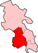 | |
|---|---|---|
| Other civil parishes (component villages and hamlets) |
| |
| Former districts and boroughs | ||
| Former constituencies | ||
| Ancient boroughs | |
|---|---|
| Incorporated boroughs | |
| Urban districts | |
| Rural districts | |
| Civil parishes | |
Coordinates: 51°39′N 0°47′W / 51.65°N 0.78°W
This article is issued from Wikipedia - version of the 9/7/2016. The text is available under the Creative Commons Attribution/Share Alike but additional terms may apply for the media files.