Worrall Covered Bridge
|
Worrall Covered Bridge | |
|
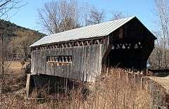
The southeast approach to the Worrall bridge. Note the rare wooden ramp on the opposite end. | |
| Nearest city | Rockingham, Vermont |
|---|---|
| Coordinates | 43°12′41.77″N 72°32′8.74″W / 43.2116028°N 72.5357611°WCoordinates: 43°12′41.77″N 72°32′8.74″W / 43.2116028°N 72.5357611°W |
| Area | less than one acre |
| Built | 1870 |
| Architect | Granger,Sanford |
| Architectural style | Town lattice truss |
| NRHP Reference # | 73000209[1] |
| Added to NRHP | July 16, 1973 |
| Wikimedia Commons has media related to Worrall Covered Bridge. |
The Worrall Covered Bridge, also known as the Woralls Bridge is a wooden covered bridge carrying Williams Road across the Williams River in Rockingham, Vermont, United States. Built about 1868, it is the only surviving 19th-century covered bridge in the town, after the Hall Covered Bridge collapsed in 1980 and was replaced in 1982. The bridge was listed on the National Register of Historic Places in 1973.[1]
Description and history
The Worrall Covered Bridge is located on Williams Road, a dirt road a short distance north of Vermont Route 103, that generally parallels the Williams River on its north side, while VT 103 follows the river on the south side. The bridge is a Town lattice truss structure, with a total span of 82 feet (25 m) and a total structure length of 87 feet (27 m). The trusses rest on stone abutments that have been reinforced with concrete, and the road bed (14 feet (4.3 m) wide, or one lane) has been reinforced with laminated beams. It is topped by a gabled metal roof, and is sheathed in vertical board siding, with openings on its south side to improve traffic visibility.[2] The bridge includes one rare feature — a wooden ramp leading up to the northwest entrance.
The bridge was built about 1868 by Sanford Granger, a local master builder. Of seventeen 19th-century bridges once located in the town, it is one of only two that remain. At the time of its National Register listing in 1973, there were three such bridges,[2] but one of them, the nearby Bartonsville Covered Bridge, was destroyed in 2011 by flooding caused by Hurricane Irene.
See also
- National Register of Historic Places listings in Windham County, Vermont
- List of bridges on the National Register of Historic Places in Vermont
References
- 1 2 National Park Service (2007-01-23). "National Register Information System". National Register of Historic Places. National Park Service.
- 1 2 "NRHP nomination for Worrall Covered Bridge" (PDF). National Park Service. Retrieved 2016-01-23.
| Topics | |
|---|---|
| Lists by states |
|
| Lists by insular areas | |
| Lists by associated states | |
| Other areas | |
| |