Woolooga
| Woolooga Queensland | |||||||||||||
|---|---|---|---|---|---|---|---|---|---|---|---|---|---|
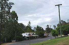 The main street of Woolooga, showing the general store, with the pub and community hall around the bend. | |||||||||||||
 Woolooga | |||||||||||||
| Coordinates | 26°03′0″S 152°24′0″E / 26.05000°S 152.40000°ECoordinates: 26°03′0″S 152°24′0″E / 26.05000°S 152.40000°E | ||||||||||||
| Population | 274 (2011 census)[1] | ||||||||||||
| Established | 1910 | ||||||||||||
| Postcode(s) | 4570 | ||||||||||||
| Location | |||||||||||||
| LGA(s) | Gympie Region | ||||||||||||
| State electorate(s) | Callide | ||||||||||||
| Federal Division(s) | Wide Bay | ||||||||||||
| |||||||||||||
Woolooga is a town and locality in the Wide Bay region of Queensland, Australia.[2][3] The town is located in the Gympie Region local government area, 221 kilometres (137 mi) north of the state capital, Brisbane. In the 2011 census, Woolooga had a population of 274 people.[1]
Geography
The town is located in the south of the locality. The railway line from Theebine to Nanango passes from the east to the south-west through the locality, but the line is no longer operating The town was served by the Woolooga railway station (26°03′01″S 152°23′33″E / 26.05028°S 152.39250°E) while the eastern part was served by the Boowoogum railway station (26°01′30″S 152°25′16″E / 26.02500°S 152.42111°E).[4][5][6]
The Wide Bay Creek meanders from the south-west of the locality to the east.[4]
History
Woolooga railway station was named in 1886 by the Queensland Railways Department and subsequently became used as the town and locality name. It is reported to be an Aboriginal word from the Kabi language with wului meaning smoke and tha meaning ground/place.[2][3]

The Woolooga Memorial Park commemorates those who served in war. It is located in Thomas Street.[7]
At the 2006 census, Woolooga and the surrounding rural area had a population of 319.[8]
Woolooga was affected by the 2010–2011 Queensland floods. A 2-metre (6.6 ft) wall of water rushed through the town, inundating the public hall and the pub.[9] The general store was also severely damaged by the flood.[10]
Heritage listings
Woolooga has a number of heritage-listed sites, including:
References
- 1 2 Australian Bureau of Statistics (31 October 2012). "Woolooga (SSC)". 2011 Census QuickStats. Retrieved 31 August 2016.
- 1 2 "Woolooga - town (entry 38055)". Queensland Place Names. Queensland Government. Retrieved 31 August 2016.
- 1 2 "Woolooga - locality (entry 46403)". Queensland Place Names. Queensland Government. Retrieved 31 August 2016.
- 1 2 "Queensland Globe". State of Queensland. Retrieved 31 August 2016.
- ↑ "Woolooga - railway station (entry 38056)". Queensland Place Names. Queensland Government. Retrieved 31 August 2016.
- ↑ "Boowoogum - railway station (entry 3842)". Queensland Place Names. Queensland Government. Retrieved 31 August 2016.
- ↑ "Woolooga Memorial Park". Monument Australia. Retrieved 6 April 2014.
- ↑ Australian Bureau of Statistics (25 October 2007). "Woolooga (Kilkivan Shire) (State Suburb)". 2006 Census QuickStats. Retrieved 19 January 2011.
- ↑ "Western areas hit with record rain". Gympie Times. 9 January 2011. Retrieved 19 January 2011.
- ↑ Harch, Christine (19 January 2011). "Spirit not dampened by floods". Gympie Times. Retrieved 19 January 2011.
- ↑ "Woolooga Rail Bridge (entry 600645)". Queensland Heritage Register. Queensland Heritage Council. Retrieved 8 July 2013.
External links
![]() Media related to Woolooga, Queensland at Wikimedia Commons
Media related to Woolooga, Queensland at Wikimedia Commons