M-1 (Michigan highway)
| ||||
|---|---|---|---|---|
| Woodward Avenue | ||||
|
M-1 highlighted in red | ||||
| Route information | ||||
| Maintained by MDOT | ||||
| Length: | 21.488 mi[1] (34.582 km) | |||
| History: | Woodward Avenue platted in 1805 and designated M-1 in 1970[2] | |||
| Tourist routes: |
| |||
| Major junctions | ||||
| South end: | Adams Avenue in Detroit | |||
|
| ||||
| North end: |
| |||
| Location | ||||
| Counties: | Wayne, Oakland | |||
| Highway system | ||||
| ||||

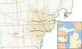
M-1, commonly known as Woodward Avenue, is a north–south state trunkline highway in the Metro Detroit area of the US state of Michigan. The highway, called "Detroit's Main Street", runs from Detroit north-northwesterly to Pontiac. The street is one of the five principal avenues of Detroit, which also include Michigan, Grand River, Gratiot and Jefferson avenues. These streets were platted in 1805 by Judge Augustus B. Woodward, namesake to Woodward Avenue. The US Department of Transportation has listed the highway as the Automotive Heritage Trail, an All-American Road in the National Scenic Byways Program. It has also been designated a Pure Michigan Byway by the Michigan Department of Transportation (MDOT). The roadway was also included in the MotorCities National Heritage Area designated by the US Congress in 1998.
The trunkline is the dividing line between Detroit's East and West sides, and it connects to some of the city's major freeways like Interstate 94 (I-94, Edsel Ford Freeway) and M-8 (Davison Freeway). Woodward Avenue exits Detroit at M-102 (8 Mile Road) and runs through the city's northern suburbs in Oakland County on its way to Pontiac. In between, Woodward Avenue passes through several historic districts in Detroit and provides access to many businesses in the area. The name Woodward Avenue has become synonymous with Detroit, cruising culture and the automotive industry.
Woodward Avenue was created after the Detroit Fire in 1805. It followed the route of the Saginaw Trail, an Indian trail that linked Detroit with Pontiac, Flint, and Saginaw. The Saginaw Trail also connected to the Mackinaw Trail, which ran north to the Straits of Mackinac at the tip of the Lower Peninsula of Michigan. In the age of the auto trails, Woodward Avenue was also part of the Theodore Roosevelt International Highway that connected Portland, Maine, with Portland, Oregon through Ontario in Canada. It was also a part of the Dixie Highway, which connected Michigan with Florida. Woodward Avenue was the location of the first mile (1.6 km) of concrete roadway in the country. When Michigan created the State Trunkline Highway System in 1913, the roadway was included, numbered as part of M-10 in 1919. Later, it was part of US Highway 10 (US 10) following the creation of the United States Numbered Highway System. Since 1970, it has borne the M-1 designation. The roadway carried streetcar lines from the 1860s until the 1950s; a new light rail line will be added in the future.
Route description
Like other state highways in Michigan, the section of Woodward Avenue designated M-1 is maintained by MDOT. In 2011, the department's traffic surveys showed that on average, 64,176 vehicles used the highway daily north of 11 Mile Road and 14,592 vehicles did so each day near Grand Boulevard, the highest and lowest counts along the highway, respectively.[3] All of M-1 north of I-75 is listed on the National Highway System,[4][5] a network of roads important to the country's economy, defense, and mobility.[6] In addition to the sections of Woodward Avenue in Pontiac that are part of Business Loop I-75 (BL I-75) and Business US 24 (Bus. US 24), all of M-1 is a Pure Michigan Byway and an All-American Road.[7] Woodward Avenue is also considered to be the divider between the East and West sides of the city of Detroit.[8]
Detroit and Highland Park
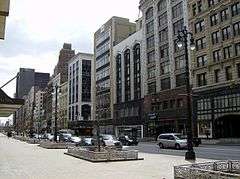
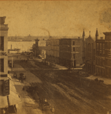
Woodward Avenue starts at an intersection with Jefferson Avenue next to Hart Plaza about 750 feet (230 m) from the Detroit River.[7][9] The plaza is regarded as the birthplace of the Ford Motor Company,[10] and it is located near Cobo Center and the Renaissance Center, headquarters for General Motors (GM).[11] Woodward Avenue runs north-northwesterly away from the river through the heart of downtown Detroit and the Financial District. Along the way, it passes several important and historic sites, including notable buildings like One Woodward Avenue, the Guardian Building and The Qube. Woodward also passes The Spirit of Detroit, a statue used to symbolize the city. Further north, Woodward Avenue runs around Campus Martius Park and enters the Lower Woodward Avenue Historic District, a retail, commercial, and residential district listed on the National Register of Historic Places (NRHP). After that historic district, the avenue travels through the middle of Grand Circus Park; the northern edge of the park is bounded by Adams Avenue, where state maintenance begins.[7][9]
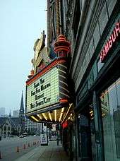
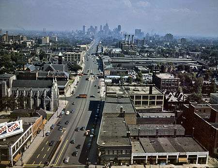
North of Adams Avenue, Woodward Avenue is a state trunkline designated M-1. The highway crosses to the west of Comerica Park and Ford Field, home of Major League Baseball's Detroit Tigers and the National Football League's Detroit Lions, respectively. Woodward also passes the historic Fox Theatre before it crosses over I-75 (Fisher Freeway) without an interchange; access between the two highways is through the service drives that connect to adjacent interchanges. A six-lane street, the highway travels through mixed residential and commercial areas of Midtown including the Midtown Woodward Historic District, another district listed on the NRHP. South of I-94, Woodward heads through the Cultural Center Historic District, which includes the campus of Wayne State University, the Detroit Public Library, and the Detroit Institute of Arts (DIA).[7][9] The DIA and the nearby Detroit Historical Museum both feature exhibits showcasing the city's automotive history.[12]
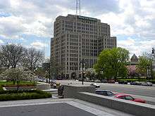
North of I-94, Woodward passes through New Center; this district is home to Cadillac Place, the former headquarters of GM. The neighborhoods on either side of the highway transition in composition north of New Center; this area is mostly residential in nature. Between the intersections with Webb Street/Woodland Street and Tuxedo Street/Tennyson Street, Woodward Avenue leaves the city of Detroit for the first time and crosses into Highland Park, an enclave within Detroit. It is within Highland Park that M-1 intersects M-8, the Davison Freeway. Woodward passes over the Davison, which is the first urban, depressed freeway in the US,[13] at an interchange south of Highland Park's downtown business district. M-1 crosses that district and runs next to the historic Highland Park Ford Plant,[7][9] home of the original moving assembly line used to produce Model Ts;[14][15] opened in 1910, the plant's assembly line dropped the time needed to build a car from 12 hours to 93 minutes and allowed Ford to meet demand for the car.[16]
M-1 crosses back into Detroit at the intersection with McNichols Road;[7][9] the latter street occupies the 6 Mile location in Detroit's Mile Road System.[17] North of this intersection, Woodward Avenue widens into a boulevard, a divided street with a median; left turns along this section of roadway are made by performing a Michigan left maneuver using the U-turn crossovers in the median. Between McNichols and 7 Mile Road, Woodward Avenue travels to the east of the Detroit Golf Club in the Palmer Park area. North of 7 Mile, the highway runs to the west of the Michigan State Fairgrounds and to the east of the Palmer Woods Historic District. The northern edge of the fairgrounds is at M-102 (8 Mile Road), which is also where Woodward Avenue exits Detroit for the second time; the two boulevards cross in a large interchange.[7][9]
Oakland County
Crossing the border into the suburb of Ferndale in Oakland County, the highway runs through residential neighborhoods but is lined with adjacent businesses. The intersection with 9 Mile Road marks the suburb's downtown area. Further north in Pleasant Ridge, the north-northwesterly path of Woodward Avenue changes as the road turns to the northwest. After the curve, M-1 meets I-696 (Reuther Freeway); immediately north of this interchange in Huntington Woods is the Detroit Zoo. North of 11 Mile Road, Woodward Avenue forms the border between Berkley to the west and Royal Oak to the east. The highway passes the Roseland Park Cemetery north of 12 Mile Road before crossing fully into Royal Oak. Near 13 Mile Road, the trunkline passes through a commercial district anchored by a shopping center and the Beaumont Hospital. North of 14 Mile Road in Birmingham, M-1 and Woodward Avenue leaves its original route, which is named Old Woodward Avenue, and runs to the east of it to bypass that suburb's downtown area. The highway crosses the River Rouge and returns to its original routing north of Maple (15 Mile[17]) Road.[7][9]
North of Birmingham, Woodward crosses through part of Bloomfield Township for the first time before entering Bloomfield Hills. That suburb's downtown is centered on the intersection with Long Lake Road; Woodward passes between a pair of golf courses north of there. The highway enters the south side of Pontiac's residential neighborhoods after crossing back into Bloomfield Township. At the intersection with Square Lake Road, M-1 terminates. Woodward Avenue continues northwesterly into Pontiac carrying the BL I-75 and Bus. US 24 designations; it terminates after the two directions of the boulevard diverge and form a one-way loop around the city's business district.[7][9]
Cultural significance
Scenic and historic designations

Many historical sites are located along Woodward Avenue, which was included in the MotorCities National Heritage Area when it was created on November 6, 1998.[18] The road was designated what is now called a Pure Michigan Byway by MDOT in 1999,[19] and a National Scenic Byway by the Federal Highway Administration (FHWA) National Scenic Byways Program on June 13, 2002,[20] the only urban road at the time with that classification.[21] It was later upgraded to All-American Road status on October 16, 2009;[22] such roads have highly unique features and are significant enough to be tourist destinations unto themselves.[23] In announcing the byway status in 2002, Norman Mineta, then United States Secretary of Transportation, said that "Woodward Avenue put the world on wheels, and America's automobile heritage is represented along this corridor."[21] Other sources have called it the "Father Road", in contrast to U.S. Route 66's title as the "Mother Road".[24]
The Woodward Avenue Action Association (WA3), the local agency that acts as the stewards and advocates for the All-American Road and Pure Michigan Byway designations as well as adjacent historical sites,[16] obtained a grant for $45,000 from the FHWA in 2011 to install a set of 50 custom road signs along M-1 between Detroit and Pontiac. The signs took 18 months to design and fabricate in consultation with the local communities, MDOT and DTE Energy.[25] The signs proved to be popular, enough so that two of them were stolen in the first months after installation.[26] WA3 is offering replicas of these unique signs to discourage theft, and the proceeds raise funds for future sign maintenance.[27] Profits are also being used along with money from clothing and other merchandise to support the Woodward Avenue Beautification Fund,[28] a special endowment created in 2010 to aid the 11 communities along the highway with maintenance and to defray costs associated with special events on the avenue.[29]
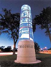
In addition to the custom signage, WA3 has received FHWA grant funding to erect a series of lighted "tributes": solar-powered, lighted pillars that contain artwork related to the roadway. The $150,000 glass and concrete sculptures are being placed in the median along Woodward Avenue to serve as landmarks along the route of the roadway and to brand it for tourists. A total of 10–12 installations are planned for the length of the highway in Wayne and Oakland counties.[30] The art project received a 2011 National Scenic Byway Award for the Byways interpretation category.[31]
Religion, entertainment, and cars
The area around Woodward was once nicknamed "Piety Hill".[8] There are 22 churches on the NRHP along the street in Detroit and Highland Park.[32] According to The Detroit News, the sounds of church bells and horse hooves were some of the most distinctive sounds on Sundays along Woodward Avenue in the early 20th century.[8] Later, the street was home to the jazz clubs of the 1910s and 1920s.[33] During the 1940s, ministers lobbied for a law to prevent the issuance of additional liquor licenses in their neighborhood; the law was overturned in 1950.[8] Nightclubs hosted a burgeoning music scene in the early days of rock 'n roll,[33] and the area also had plenty of bars and even burlesque shows as late as the 1970s. One local journalist called the mix of churches, clubs, and bars along Woodward Avenue "a precarious balance between the sacred and the profane."[8]
In addition to music clubs, many of Detroit's other important entertainment fixtures are located on or near Woodward in downtown Detroit, including the Fox Theatre, Majestic Theater and the rest of the theater district. During World War II, the area was also home to 24-hour movie theaters and bowling alleys. Curfews across the river in Windsor, Ontario, meant that many patrons during the war years were Canadian. They frequented the establishments in addition to the Americans, many of whom worked in the factories of the Detroit area. Since the 1990s, the theater district has undergone a renaissance after renovations and improvements during the 1980s.[33]
Woodward Avenue's connection to Detroit's automobile culture dates back to the early 20th century. Around 100 automobile companies were founded along the roadway.[8] Henry Ford developed and first produced the Model T in 1907–08 at his Piquette Avenue Plant to the east of Woodward Avenue. The first 12,000 Model Ts were built there,[34] before Ford moved production of his cars to the Highland Park plant adjacent to Woodward Avenue in 1910.[35] Employees at the plant used the streetcar system along Woodward to get to work;[8] these lines also provided transportation options to assembly plant workers affected by gas rationing during World War II.[36] During the 1950s and 1960s, automobile engineers street tested their cars along Woodward Avenue between 8 Mile and Square Lake roads; the roadway was the only such location where this activity was practiced.[37]
Woodward Dream Cruise
Young carriage drivers raced one another along Woodward Avenue after the roadway was converted from logs to planks in 1848. They placed bets on each other's carriages while racing from tavern to tavern.[8] By 1958, the roadway was used for unofficial street racing with cars. The wide width, median and sections lacking a large commercial presence attracted a reputation for the competition. The numerous drive-ins, each with its dedicated local teenaged clientele, were also popular. Woodward also had numerous car dealerships and automobile accessory shops in the age of the muscle car which completed the formula for young adults to cruise, race and hang out along the road.[24]
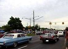
The Woodward Dream Cruise takes place on Woodward Avenue between Pontiac and Ferndale during August of each year, evoking nostalgia of the 1950s and 1960s, when it was common for young drivers to "cruise" with their cars on Woodward Avenue. The event attracts huge crowds of classic car owners and admirers from around the world to the Metro Detroit area in celebration of Detroit's automotive history. The cruise was founded in 1995 as a fundraiser for a soccer field in Ferndale. Neighboring cities joined in, and by 1997, auto manufacturers and other vendors had begun sponsoring the event.[24] An estimated one million spectators attended the 2009 event.[38]
History
Indian trails and plank roads
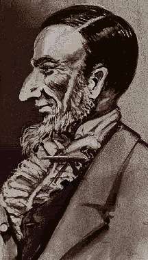
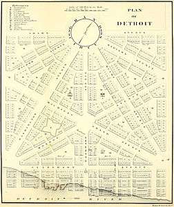
In 1701, the first transportation routes through what became the state of Michigan were the lakes, rivers and Indian trails. One of these, the Saginaw Trail, followed what is now Woodward Avenue from the Detroit area north to Saginaw, where it connected with the Mackinaw Trail north to the Straits of Mackinac.[39] The Town of Detroit[lower-alpha 1] created 120-foot-wide (37 m) rights-of-way for the principal streets of the city in 1805.[41] This street plan was devised by Augustus Woodward and others following a devastating fire in Detroit,[2] with a mandate from the territorial governor to improve on the previous plan.[42] The wide width of the avenues was an emulation of the street plan for Washington, DC, and intended to make Detroit the "Paris of the West".[8]
Augustus Woodward was a judge in the Michigan Territory appointed by his friend, President Thomas Jefferson.[42] He was also a colonel in the territorial militia and a president of one of Detroit's first banks.[43] Woodward named the street for himself, responding whimsically to the resulting criticism: "Not so. The avenue is named Woodward because it runs wood-ward, toward the woods."[42][lower-alpha 2] Other proposals for names included Court House Street or Market Street. For a time, one section was named Congress Street, Witherell Street, Saginaw Road or Saginaw Turnpike,[42] with another section dubbed Pontiac Road. Unlike these other monikers, the avenue retained the judge's name.[2]
Detroit was incorporated in 1815,[21] and the initial roadway to connect Detroit north to Pontiac along the Saginaw Trail was started in 1817; this was a corduroy road built by laying down logs and filling in the gaps with clay or sand.[44] The territorial legislature authorized a survey of the roadway to Pontiac on December 7, 1818, and the route was approved by Governor Lewis Cass on December 15, 1819,[45] the first to be done in the future state.[46] The Michigan Legislature authorized the construction of a private plank road with tolls to connect Detroit with Pontiac in 1848. By the next year, 16-foot-wide (4.9 m) and 3-inch-thick (7.6 cm) oak planks were laid along the road between the two communities. Tolls were one cent per mile (0.62 ¢/km) for vehicles and two cents per mile (1.2 ¢/km) for a herd of cattle. Tolls along some segments of Woodward Avenue remained in place as late as 1908.[47]
The first automobile in Detroit was driven by Charles Brady King along Woodward Avenue on March 3, 1896, a few weeks before Henry Ford drove his first car in the city.[48] In 1909, the first mile (1.6 km) of concrete roadway in the country was paved between 6 and 7 Mile roads at a cost of $14,000 (equivalent to $2.17 million in 2015[49]).[42][50]
State Trunkline era
On May 13, 1913, the Legislature created the state's highway system; Woodward Avenue was included as part of "Division 2".[51] The full length was paved in 1916.[2] The first crows nest traffic tower in the US was installed at the intersection of Woodward and Michigan avenues on October 9, 1917; the tower elevated a police officer above the center of the intersection to direct traffic before the structure was replaced in October 1920 with the world's first four-way traffic light.[42] The state signposted its highways in 1919,[52] and Woodward Avenue was assigned the M-10 designation.[53] The same year, two auto trail designations were applied to the avenue. The Theodore Roosevelt International Highway was created in February 1919, running from Detroit northward along Woodward Avenue.[54] Later that year, the Dixie Highway was extended through Detroit to the Straits of Mackinac,[55] following the route of the old Saginaw Trail northward along Woodward Avenue.[56]
Since 1924,[57] Woodward Avenue has hosted America's Thanksgiving Parade,[58] the second oldest Thanksgiving Day parade in the United States.[57] In 1925, the intersection between Woodward Avenue and State Street was busier than Times Square.[50] On November 11, 1926, the United States Numbered Highway System was approved by the American Association of State Highway Officials (AASHO);[59] the M-10 designation along Woodward was replaced with US 10, a moniker that ran from Detroit to Seattle, Washington.[60]
Legal disputes over a plan to widen Woodward Avenue dating back to 1874 were resolved in 1932. Permission was needed from a majority of the landowners along Woodward Avenue to finalize the deal.[2] John W. Chandler, general manager of the Woodward Avenue Improvement Association,[61] pledged not to shave his face until he had the necessary permissions in hand. This resolution allowed Woodward to be widened from 66 to 120 feet (20 to 37 m). Several buildings were removed to clear the wider street path, and St. John's Episcopal Church was moved 60 feet (18 m) to avoid demolition.[2] Work started in 1933 and cost $7.5 million (equivalent to $919 million in 2015[49]) to complete.[47]
A bypass of downtown Birmingham opened between late 1939 and early 1940, drawing through traffic away from the busy Woodward Avenue–Maple Road intersection.[62][63] The bypass was originally named Hunter Boulevard. In 1996, though, Birmingham renamed the bypass to Woodward Avenue, with the previous alignment of Woodward signed as Old Woodward Avenue.[64][65]
In October 1969, AASHO approved the realignment of US 10 in the Detroit area;[66] the next year the designation was rerouted to follow the Lodge Freeway (what is now M-10) and the portion of Jefferson Avenue between the Lodge and Randolph Street (then US 25, now M-3). The M-1 designation was applied to the section of Woodward Avenue, from Jefferson Avenue in downtown Detroit, to Square Lake Road along the southern border of Pontiac.[2] Woodward north of Square Lake Road was designated as business routes of US 10 and I-75. When US 10 was truncated to Bay City in 1986, the Bus. US 10 portion of Woodward became Bus. US 24.[67][68]
In the early 1980s, M-1 was truncated in downtown Detroit, as the Woodward Mall was designated in the area around Cadillac Square.[69][70] At the end of 2000, MDOT proposed several highway transfers in Detroit. Some of these involved transferring city streets in the Campus Martius Park area under the department's jurisdiction to city control; another part of the proposal involved MDOT assuming control over a section of Woodward Avenue from Adams Avenue south to Grand River Avenue.[71] These transfers were completed the following year.[72][73] In 2004, however, the southern terminus was moved north three blocks to Adams Avenue.[74][75]
Streetcars and subways
On August 27, 1863, the Detroit City Railway Company (DCRC) established streetcar service along Woodward from Jefferson to Adams avenues. The company was formed by investors from Syracuse, New York, earlier that year. Later, on September 18, 1886, a separate electrified line, the Highland Park Railway, was added that ran along Woodward Avenue through Highland Park.[76] In mid-December 1893, the main streetcar line was electrified by the DCRC.[77] In 1901, the various lines throughout the city were consolidated as the Detroit United Railway.[76]
Detroit took control of the Detroit Unified Railway on May 15, 1922; afterwards, the streetcar system became the city's Department of Street Railways.[76][lower-alpha 3] Following the change in control, the city also formed the Detroit Rapid Transit Commission to build a subway system.[78] Early proposals included a station under Woodward Avenue next to Detroit City Hall.[79] In 1926, a four-line system encompassing 47 miles (76 km) of lines was proposed at a cost of $280 million (equivalent to $18.7 billion in 2015[49]). By 1929, plans were scaled back further in the face of tough local economic conditions; the plan submitted to voters included one line of 13.3 miles (21.4 km) that interconnected with the city's streetcar system with two 2.5-mile-long (4.0 km) streetcar tunnels. The bond proposal failed by a 2.5:1 margin that year, killing any proposal for a city subway system in Detroit.[78]
The street car system, like those in other cities across the US, fell into decline after World War II. Unlike the Great American streetcar conspiracy alleged in other cities, the decline of Detroit's publicly owned system was related to a multitude of different factors. Increased spending on roads benefitted competing bus lines, and zoning changes coupled with freeway construction shifted the city's population to areas away from the older street car lines. During the early 1950s, several lines were converted to buses after labor strikes, and other lines were eliminated completely.[80] Later on April 8, 1956, a parade was held when the last streetcars stopped running along Woodward Avenue and in Detroit;[81] the remaining cars were sent to Mexico City.[8]
Future
Local business and government officials have proposed two projects to add modern streetcars to M-1. The Woodward Avenue Light Rail line was a proposed light rail line that would have run for approximately nine miles (14 km) along Woodward Avenue from the transit center at Michigan Avenue north to the state fairgrounds.[82] Another proposed venture, the M-1 Rail Line, would run for 3.4 miles (5.5 km) in the downtown area only.[83] Suggestions to unify the two plans were made in late 2008,[84] and the Detroit City Council approved the sale of $125 million in bonds on April 11, 2011, for the longer system.[82] The line was approved by the Federal Transit Administration on August 31, 2011, with service expected at the time to start in 2015.[85] However, just months later, the federal government withdrew its support for the longer proposed line, in favor of a bus rapid transit system which would serve the city and its suburbs;[86] Woodward Avenue would have a dedicated bus lane under this system.[87] This decision was made after talks between Secretary of Transportation Ray LaHood, Detroit Mayor Dave Bing and Governor Rick Snyder.[86]
Private investors who supported the shorter three-mile line to New Center stated that they would continue developing that project.[88] In January 2013, LaHood announced $15 million in federal funding for the M-1 Rail Line.[89] The final environmental clearance was granted in April 2013 to allow the project to start right-of-way purchases and construction.[90] Construction started on July 28, 2014. The streetcar line will stretch from downtown Detroit to Grand Boulevard in New Center. There will be 20 different stations serving 12 stops, with most of the stations being curbside on either side of Woodward Avenue going uptown or downtown, but changing to center road stations at the north and south ends of the system. The streetcar line is expected to be operational in late 2016.[91]
Major intersections
| County | Location | mi[1] | km | Destinations | Notes |
|---|---|---|---|---|---|
| Wayne | Detroit | 0.000 | 0.000 | Adams Avenue Woodward Avenue south | Southern terminus of M-1; Woodward Avenue continues to Jefferson Avenue |
| 2.053– 2.065 | 3.304– 3.323 | Indirect access from exit 215C on eastbound I-94 | |||
| Highland Park | 5.115– 5.127 | 8.232– 8.251 | |||
| Wayne–Oakland county line | Detroit–Ferndale city line | 8.453– 8.463 | 13.604– 13.620 | Three-level diamond interchange | |
| Oakland | Royal Oak | 10.688– 10.700 | 17.201– 17.220 | Exit 16 on I-696 | |
| Pontiac | 21.460– 21.488 | 34.537– 34.582 | Northern terminus of M-1; Woodward Avenue continues into downtown Pontiac | ||
| 1.000 mi = 1.609 km; 1.000 km = 0.621 mi | |||||
See also
 Metro Detroit portal
 Michigan Highways portal
Notes
- ↑ Detroit was incorporated as a town in 1802 by the government of the Northwest Territory before incorporation and reincorporation as a city by the Michigan Territory in 1806 and 1815.[40]
- ↑ Woodward used other similar word plays to explain street names, according to George Catlin, a Detroit historian. "Atwater Street, the Judge said, was not named for Reuben Atwater, but because it was literally 'at water,' being on the riverfront".[2]
- ↑ Since July 1, 1974, the Department of Street Railways has been renamed the Detroit Department of Transportation, the agency responsible for the city's bus system. That bus system was started in 1925 as a feeder network to serve the street car lines.[76]
References
- 1 2 Michigan Department of Transportation & Michigan Center for Shared Solutions and Technology Partnerships (2009). MDOT Physical Reference Finder Application (Map). Michigan Department of Transportation. Retrieved June 4, 2012.
- 1 2 3 4 5 6 7 8 Baulch, Vivian M. (June 13, 1999). "Woodward Avenue, Detroit's Grand Old 'Main Street'". The Detroit News. ISSN 1055-2715. OCLC 137348716. Archived from the original on August 21, 2012. Retrieved June 6, 2012.
- ↑ Bureau of Transportation Planning (2008). "Traffic Monitoring Information System". Michigan Department of Transportation. Retrieved June 30, 2012.
- ↑ Michigan Department of Transportation (2005). National Highway System: City of Detroit (PDF) (Map). Scale not given. Lansing: Michigan Department of Transportation. Retrieved October 7, 2008.
- ↑ Michigan Department of Transportation (2005). National Highway System: Detroit Urbanized Area (PDF) (Map). Scale not given. Lansing: Michigan Department of Transportation. Retrieved October 7, 2008.
- ↑ Natzke, Stefan; Neathery, Mike & Adderly, Kevin (June 20, 2012). "What is the National Highway System?". National Highway System. Federal Highway Administration. Retrieved July 1, 2012.
- 1 2 3 4 5 6 7 8 9 Michigan Department of Transportation (2012). Pure Michigan: State Transportation Map (Map). c. 1:158,400. Lansing: Michigan Department of Transportation. Detroit Area inset. §§ B9–F11. OCLC 42778335, 794857350.
- 1 2 3 4 5 6 7 8 9 10 Whitall, Susan (March 12, 2007). "Woodward Avenue: Michigan's Main Street". The Detroit News. pp. 1A, 8A. ISSN 1055-2715. OCLC 137348716. Archived from the original on August 21, 2012. Retrieved July 16, 2012.
- 1 2 3 4 5 6 7 8 Google (July 16, 2012). "Overview Map of M-1" (Map). Google Maps. Google. Retrieved July 16, 2012.
- ↑ Michigan Department of Natural Resources (n.d.). Ford Motor Company (Michigan State Historical Marker). Hart Plaza, Detroit: Michigan Department of Natural Resources. Retrieved December 8, 2012.
- ↑ Nissen, Todd (May 17, 1996). "GM Buys Renaissance Center for its World Headquarters". The Buffalo News. Reuters. ISSN 0745-2691. OCLC 61311995, 867310047. Retrieved December 8, 2012. (subscription required (help)).
- ↑ Federal Highway Administration. "Woodward Avenue Auto History Tour". America's Byways. Federal Highway Administration. Retrieved December 8, 2012.
- ↑ Michigan Department of Transportation (June 3, 2008). "National Firsts". Michigan Department of Transportation. Retrieved November 8, 2008.
- ↑ Michigan State Housing Development Authority (June 22, 2012). "Highland Park Ford Plant". Historic Sites Online. Michigan State Housing Development Authority. Retrieved December 12, 2012.
- ↑ National Park Service. "Highland Park Ford Plant". Detroit: A National Register of Historic Places Travel Itinerary. National Park Service. Retrieved December 12, 2012.
- 1 2 Lombard, Stefan (Spring 2014). "Saving the Model T Plant". Hagerty Classic Cars: 68. ISSN 2162-8033. OCLC 746155690.
- 1 2 Gavrilovich, Peter & McGraw, Bill (2000). The Detroit Almanac: 300 Years of Life in the Motor City. Detroit: Detroit Free Press. pp. 20–1. ISBN 978-0-937247-34-1. OCLC 45227386.
- ↑ "Nov 6, 1998: President Clinton designates 'Automobile National Heritage Area' in Detroit". This Day in History. The History Channel. Archived from the original on August 21, 2012. Retrieved April 23, 2012.
- ↑ Ballou, Brian (August 4, 1999). "Woodward Winner Storied Avenue Labeled a Michigan Heritage Road: Plans In Works For Continuous Identity From Detroit To Pontiac". Detroit Free Press. p. B1. ISSN 1055-2758. OCLC 10345127, 137343179. Retrieved July 14, 2012. (subscription required (help)).
- ↑ Dietderich, Andrew (April 19, 2004). "Woodward Group To Add Members South of Eight Mile". Crain's Detroit Business. Detroit: Crain Communications. Retrieved July 15, 2012. (subscription required (help)).
- 1 2 3 Michigan Department of Transportation (Winter 2003). "Woodward Avenue: A Road to the Heart and Soul of America" (PDF). MDOT Today. Michigan Department of Transportation: 8–9. Archived from the original on August 21, 2012. Retrieved August 30, 2009.
- ↑ Tamboer, Andrea (October 28, 2009). "Woodward Avenue (M-1) Gets All-American Road Designation". Detroit: Booth Newspapers. Archived from the original on July 24, 2012. Retrieved July 14, 2012.
- ↑ Federal Highway Administration (August 17, 2011). "America's Byways Fact Sheet" (PDF). America's Byways. Federal Highway Administration. Retrieved September 22, 2012.
- 1 2 3 Genat, Robert (2010). Woodward Avenue: Cruising the Legendary Strip. North Branch, MN: CarTech Books. pp. 15, 41, 90, 124–5. ISBN 978-1-932494-91-4. OCLC 505927336.
- ↑ Shine, Kim North (February 23, 2011). "Woodward Avenue Gets 50 New Signs, All-American Road Designation". Prosper. Pontiac, MI: Oakland County. Archived from the original on July 24, 2012. Retrieved July 24, 2012.
- ↑ Rosenberg, Michael (June 27, 2011). "New Signs Designating Woodward Avenue 'All-American Road' Stolen". Detroit: WXYZ-TV. Archived from the original on July 24, 2012. Retrieved July 24, 2012.
- ↑ Welch, Sherri (June 23, 2011). "Capitalizing on the Theft of 'All-American Road' Signs on Woodward". Crain's Detroit Business Staff Blogs. Detroit: Crain Communications. Archived from the original on July 14, 2012. Retrieved July 24, 2012.
- ↑ Oosting, Jonathan (December 15, 2011). "Woodward on a Onesie: New Merch Celebrates, Benefits Metro Detroit's 'All-American Road' ". MLive. Detroit: Booth Newspapers. Archived from the original on July 28, 2012. Retrieved July 28, 2012.
- ↑ Welch, Sherri (February 26, 2010). "Woodward Avenue Action Association Creates Fund To Help Municipalities". Crain's Detroit Business. Detroit: Crain Communications. Retrieved August 1, 2013.
- ↑ Kavanaugh, Catherine (April 18, 2012). "Royal Oak Auto Designer Pays Tribute to Woodward Avenue". The Daily Tribune. Mount Clemens, MI. Archived from the original on July 24, 2012. Retrieved July 24, 2012.
- ↑ Carmona, Heather. "Woodward Avenue Tribute Program" (PDF). Woodard Avenue Action Association. Archived from the original on August 21, 2012. Retrieved July 24, 2012.
- ↑ National Park Service (January 23, 2007). "National Register Information System". National Register of Historic Places. National Park Service. Retrieved July 17, 2012.
- 1 2 3 Whitall, Susan (March 26, 2007). "Woodward: Avenue of Escape". The Detroit News. pp. 1A, 4A. ISSN 1055-2715. OCLC 137348716. Archived from the original on August 21, 2012. Retrieved July 16, 2012.
- ↑ Model T Automotive Heritage Complex. "History of the Model T Factory: Development of the Model T". Model T Automotive Heritage Complex. Retrieved December 8, 2012.
- ↑ Ambrogio, Anthony & Luckerman, Sharon (2006). Cruisin' the Original Woodward Avenue. Images of America. Charleston, SC: Arcadia Publishing. p. 15. ISBN 0-7385-4045-5. OCLC 70850661.
- ↑ Shea, Bill (August 18, 2008). "Detroit Had Light Rail until the 1950s". Crain's Detroit Business. Detroit: Crain Communications. Archived from the original on August 21, 2012. Retrieved August 20, 2012.
- ↑ Woodward Avenue Action Association. Birthplace of the Automobile Industry (PDF) (Pamphlet). Woodward Avenue Action Association. Retrieved December 8, 2012.
- ↑ Anderson, Elisha (August 22, 2010). "Weather Blamed for Smaller Attendance at Dream Cruise". Detroit Free Press. ISSN 1055-2758. OCLC 10345127, 137343179. Archived from the original on August 21, 2012. Retrieved August 22, 2010.
- ↑ Mason, Philip P. (1959). Michigan Highways from Indian Trails to Expressways. Ann Arbor, MI: Braun-Brumfield. p. 4. OCLC 23314983.
- ↑ Farmer, Silas (1889). The History of Detroit and Michigan; or, The Metropolis Illustrated; A Full Record of Territorial Days in Michigan, and the Annals of Wayne County (2nd ed.). Detroit: S. Farmer & Co. pp. 133–5. OCLC 2823136.
- ↑ Lingeman, Stanley D. (April 6, 2001). Michigan Highway History Timeline 1701–2001: 300 Years of Progress. Lansing, MI: Library of Michigan. p. 1. OCLC 435640179.
- 1 2 3 4 5 6 Barnett, LeRoy (2004). A Drive Down Memory Lane: The Named State and Federal Highways of Michigan. Allegan Forest, MI: Priscilla Press. pp. 243–4. ISBN 1-886167-24-9. OCLC 57425393.
- ↑ Bailey, Mary (February 17, 2000). "Detroit's Street Names Honor Early Leaders". The Detroit News. ISSN 1055-2715. OCLC 137348716. Archived from the original on October 21, 2012. Retrieved October 20, 2012.
- ↑ Bel Geddes, Norman (1940). Magic Motorways. New York: Random House. p. 27. OCLC 751992. Retrieved August 20, 2012.
- ↑ Barnett, LeRoy (2004). A Drive Down Memory Lane: The Named State and Federal Highways of Michigan. Allegan Forest, MI: Priscilla Press. pp. 192–3. ISBN 1-886167-24-9. OCLC 57425393.
- ↑ Michigan Department of Transportation (June 18, 2010). "Road & Highway Facts". Michigan Department of Transportation. Archived from the original on August 21, 2012. Retrieved September 27, 2010.
- 1 2 Gavrilovich, Peter & McGraw, Bill (2000). The Detroit Almanac: 300 Years of Life in the Motor City. Detroit: Detroit Free Press. pp. 236–8. ISBN 978-0-937247-34-1. OCLC 45227386.
- ↑ Llewellin, Phil (March 16, 1996). "In the US Motoring Centenary, Speed Freaks Are Heading for Michigan". The Independent. London. p. 12. ISSN 0951-9467. OCLC 15051443. Retrieved September 21, 2012 – via Questia. (subscription required (help)).
- 1 2 3 United States nominal Gross Domestic Product per capita figures follow the Measuring Worth series supplied in Johnston, Louis; Williamson, Samuel H. (2016). "What Was the U.S. GDP Then?". MeasuringWorth. Retrieved April 10, 2016. These figures follow the figures as of 2015.
- 1 2 Stein, Jason (September 13, 2009). "Detroit: The Place Isn't Quite What It Used To Be". Daily Herald. Arlington Heights, IL. p. 1. OCLC 18030507. Retrieved September 21, 2012. (subscription required (help)).
- ↑ Michigan Legislature (1915). "Chapter 91: State Reward Trunk Line Highways". In Shields, Edmund C.; Black, Cyrenius P. & Broomfield, Archibald. The Compiled Laws of the State of Michigan, Volume I. Lansing, MI: Wynkoop, Hallenbeck, Crawford. pp. 1868–72. OCLC 44724558. Retrieved January 24, 2012.
- ↑ "Michigan May Do Well Following Wisconsin's Road Marking System". The Grand Rapids Press. September 20, 1919. p. 10. OCLC 9975013.
- ↑ Michigan State Highway Department (July 1, 1919). State of Michigan (Map). Scale not given. Lansing: Michigan State Highway Department. Lower Peninsula sheet. OCLC 15607244.
- ↑ Skidmore, Max J. (2007). Moose Crossing: Portland to Portland on the Theodore Roosevelt International Highway. Lanham, MD: Hamilton Books. pp. 7, 72. ISBN 978-0-7618-3510-3. OCLC 80156759.
- ↑ "System of Roads Urged by Hoosier State Automobile Association". Fort Wayne News and Sentinel. August 27, 1919. p. 6. OCLC 11658858.
- ↑ Rand McNally (1921). "District 3, Southern Peninsula of Michigan, Northern Indiana, Northwestern Ohio" (Map). Official Auto Trails Map. 1:633,600. Chicago: Rand McNally.
- 1 2 "Correct! Philadelphia Held Its First Parade in 1920". Our Daily Holiday Quiz. Portland, OR: KPTV-TV. Archived from the original on November 26, 2012. Retrieved November 20, 2012.
- ↑ "See The Official Parade Route: Woodward Ave. Comes Alive With America's Thanksgiving Parade". Click On Detroit. Detroit: WDIV-TV. November 13, 2006. Archived from the original on June 9, 2011. Retrieved May 26, 2011.
- ↑ NcNichol, Dan (2006). The Roads that Built America. New York: Sterling. p. 74. ISBN 1-4027-3468-9. OCLC 63377558.
- ↑ Bureau of Public Roads & American Association of State Highway Officials (November 11, 1926). United States System of Highways Adopted for Uniform Marking by the American Association of State Highway Officials (Map). 1:7,000,000. Washington, DC: United States Geological Survey. OCLC 32889555. Retrieved November 7, 2013 – via University of North Texas Libraries.
- ↑ "News from Other Cities: Detroit" (PDF). New York Evening Post. February 4, 1929. p. 28. OCLC 9517291. Retrieved September 23, 2012.
- ↑ Michigan State Highway Department & Rand McNally (December 1, 1939). Official Michigan Highway Map (Map) (Winter ed.). Scale not given. Lansing: Michigan State Highway Department. Detroit & Vicinity inset. OCLC 12701143.
- ↑ Michigan State Highway Department & Rand McNally (April 15, 1940). Official Michigan Highway Map (Map) (Spring ed.). Scale not given. Lansing: Michigan State Highway Department. Detroit & Vcinity inset. OCLC 12701143.
- ↑ Michigan Department of Transportation (1996). Michigan Department of Transportation Map (Map). c. 1:158,400. Lansing: Michigan Department of Transportation. Detroit and Vicinity inset. OCLC 42778335, 41545375.
- ↑ Michigan Department of Transportation (1997). Michigan Department of Transportation Map (Map). c. 1:158,400. Lansing: Michigan Department of Transportation. Detroit and Vicinity inset. OCLC 42778335, 39132463.
- ↑ U.S. Route Numbering Subcommittee (October 26, 1969). "U.S. Route Numbering Subcommittee Agenda Showing Action Taken by the Executive Committee" (PDF) (Report). Philadelphia, PA: American Association of State Highway Officials. p. 2. Retrieved August 2, 2014 – via Wikimedia Commons.
- ↑ Michigan Department of Transportation (1986). Yes Michigan: Official Transportation Map (Map). c. 1:158,400. Lansing: Michigan Department of Transportation. Detroit and Vicinity inset. OCLC 12701177.
- ↑ Michigan Department of Transportation (1987). Yes Michigan: Official Transportation Map (Map). c. 1:158,400. Lansing: Michigan Department of Transportation. Detroit and Vicinity inset. OCLC 12701177.
- ↑ Michigan Department of Transportation (1981). Michigan, Great Lake State: Official Transportation Map (Map) (1980–81 ed.). c. 1:158,400. Lansing: Michigan Department of Transportation. Detroit and Vicinity inset. § E5. OCLC 12701177, 606211521.
- ↑ Michigan Department of Transportation (1982). Say Yes to Michigan!: Official Transportation Map (Map). c. 1:158,400. Lansing: Michigan Department of Transportation. Detroit and Vicinity inset. § E5. OCLC 12701177, 320798736.
- ↑ Michigan Department of Transportation (November 7, 2000). Proposed Jurisdiction Transfers in the City of Detroit (PDF) (Map). Scale not given. Lansing: Michigan Department of Transportation. Archived from the original on August 21, 2012. Retrieved January 12, 2012.
- ↑ Michigan Department of Transportation (2001). Michigan, Great Lakes Great Times: Official Department of Transportation Map (Map). c. 1:158,400. Lansing: Michigan Department of Transportation. Detroit and Vicinity inset. OCLC 42778335.
- ↑ Michigan Department of Transportation (2002). Michigan, Great Lakes Great Times: Official Department of Transportation Map (Map). c. 1:158,400. Lansing: Michigan Department of Transportation. Detroit and Vicinity inset. OCLC 42778335.
- ↑ Michigan Department of Transportation (2004). Michigan: Official Department of Transportation Map (Map) (2003–04 ed.). c. 1:158,400. Lansing: Michigan Department of Transportation. Detroit and Vicinity inset. OCLC 42778335, 53197160.
- ↑ Michigan Department of Transportation (2005). Michigan, One Hundred Years of Michigan Transportation: Official Department of Transportation Map (Map). Scale not given. Lansing: Michigan Department of Transportation. Greater Detroit inset. OCLC 42778335, 71041619.
- 1 2 3 4 Schramm, Kenneth (2006). Detroit's Street Railways. Images of Rail. Charleston, SC: Arcadia Publishing. pp. 7–8, 11–13. ISBN 0-7385-4027-7. OCLC 67975025.
- ↑ Zachary and Associates, Inc. (July 30, 1997). "Historic and Architectural Resources of the Cass Farm Survey Area, Detroit, Wayne County, Michigan" (PDF). National Register of Historic Places. National Park Service. p. 5. Retrieved August 20, 2012.
- 1 2 Fogelson, Robert M. (2001). Downtown: Its Rise and Fall, 1880–1950. New Haven: Yale University Press. pp. 85–8. ISBN 978-0-300-09062-8. OCLC 182530522. Retrieved October 22, 2012.
- ↑ Parsons, Brinckerhoff, Quade & Douglas (1915). Report on Detroit Street Railway Traffic and Proposed Subway, Made to Board of Street Railway Commissioners, City of Detroit (Report). New York: Parsons, Brinckerhoff, Quade & Douglas. p. 115. OCLC 5463777. Retrieved October 8, 2012.
- ↑ Jackman, Michael (March 29, 2006). "Back Track: Fifty Years after the Motor City Rode the Rails". Metro Times. ISSN 0746-4045. OCLC 10024235. Retrieved October 22, 2012.
- ↑ Kurlyandchik, Mark (May 2012). "After 50+ Years, Streetcars Could Come Back to Woodward". Hour Detroit. ISSN 1098-9684. OCLC 36812180. Archived from the original on August 21, 2012. Retrieved August 20, 2012.
- 1 2 "City Council Approves Detroit Light Rail Project". Detroit: WWJ-TV. April 12, 2011. Archived from the original on July 16, 2012. Retrieved July 15, 2012.
- ↑ Oosting, Jonathan (November 2, 2009). "Woodward Light-Rail Project in Detroit Could Lose Matching Federal Funds for Extension". MLive. Detroit: Booth Newspapers. Archived from the original on October 5, 2012. Retrieved October 5, 2012.
- ↑ Forman, Minehaha (November 15, 2008). "Detroit Looks To 'Unify' Rival Light-Rail Transit Plans". The Michigan Messenger. Archived from the original on October 9, 2012. Retrieved October 8, 2012.
- ↑ Wayland, Michael (September 6, 2011). "Detroit's Woodward Ave. Light Rail Project Moves Forward, but Still Has Long Road to Completion". MLive. Detroit: Booth Newspapers. Archived from the original on December 15, 2011. Retrieved December 15, 2011.
- 1 2 Helms, Matt (December 15, 2011). "For Less Than $500M, a Bus Rapid Transit System Could Cover Nearly 110 Miles". Detroit Free Press. p. 17A. ISSN 1055-2758. OCLC 10345127, 137343179. Archived from the original on August 2, 2012. Retrieved August 2, 2012.
- ↑ AlHajal, Khalil (December 17, 2012). "Detroit-Area Group To Check Out Cleveland's Bus Rapid Transit System After Legislation Opens Doors". MLive. Detroit: Booth Newspapers. Retrieved December 27, 2012.
- ↑ Helms, Matt; Egan, Paul & Gallagher, John (December 14, 2011). "Detroit Light-Rail Plan Is Dead: Buses Will Be Used Instead". Detroit Free Press. pp. 1A, 6A. ISSN 1055-2758. OCLC 10345127, 137343179.
- ↑ Helms, Matt (January 18, 2013). "Transportation Secretary Ray LaHood Brings $25 Million in Federal Aid for M-1 Rail Project". Detroit Free Press. Archived from the original on January 18, 2013. Retrieved January 18, 2013.
- ↑ Helms, Matt (April 23, 2013). "M-1 Rail Project Gets Final OK from Federal Government". Detroit Free Press. Retrieved April 23, 2013.
- ↑ "Construction Starts on Detroit Rail". The Mining Journal. Marquette, MI. Associated Press. July 28, 2014. p. 5A. ISSN 0898-4964. OCLC 9729223.
External links
| Wikimedia Commons has media related to M-1 (Michigan highway). |
 Geographic data related to M-1 (Woodward Avenue) at OpenStreetMap
- M-1 at Michigan Highways
- Woodward Avenue (M-1) Automotive Heritage Trail National Scenic Byway at America's Byways (Federal Highway Administration)
- Official Byway Homepage, Woodward Avenue Action Association
- The Woodward Dream Cruise