Wolumla, New South Wales
| Wolumla New South Wales | |
|---|---|
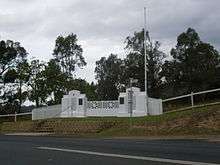
 Wolumla Railway Hotel, named after the proposed railway that would have passed right next the hotel | |
|
Wolumla | |
| Coordinates | 36°50′00″S 149°48′30″E / 36.83333°S 149.80833°ECoordinates: 36°50′00″S 149°48′30″E / 36.83333°S 149.80833°E |
| Population | 380 (2006 census)[1] |
| Postcode(s) | 2550 |
| LGA(s) | Bega Valley Shire |
| State electorate(s) | Bega |
| Federal Division(s) | Eden-Monaro |
Wolumla is an historical locality in New South Wales, Australia and is between Bega and Merimbula. Wolumla is a small rural village located off the Princes Highway to the south of Bega. Wolumla is located on rolling hills on the coastal hinterland near the headwaters of Frogs Hollow Creek and has been predominantly cleared for beef, dairy and sheep grazing. At the 2006 census, Wolumla had a population of 380.[1]
The township receives a small holiday population during peak holiday periods. The township consists of predominantly low density urban housing with a very small commercial area located on the main street consisting of a hotel, hair dresser, and general store including a post office agency. Also The Carpet Place established in 2009.
Wolumla is the home town of Australian rugby league international representative footballer, Matt McCoy.
Gold was discovered very near Wolumla in 1896.[2]
Wolumla has a public school with kindergarten to year 6, which was established in 1882.[3]
Notes and references
- 1 2 Australian Bureau of Statistics (25 October 2007). "Wolumla (L) (Urban Centre/Locality)". 2006 Census QuickStats. Retrieved 27 February 2010.
- ↑ "The Wolumla Gold Field". The Town and Country Journal. 15 January 1898. Retrieved 6 January 2016.
- ↑ "Wolumla Public School". Retrieved 5 January 2016.
| Cities | |
|---|---|
| Townships |
|
| Local government areas | |
| National parks |
|
| Rivers and other waterbodies | |