Wolf Creek Pass
| Wolf Creek Pass | |
|---|---|
|
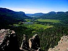
Wolf Creek Pass and Ski Area, August 2008 | |
| Elevation | 10,857 ft (3,309 m)[1] |
| Traversed by |
|
| Location | Mineral County, Colorado, United States |
| Range | San Juan Mountains |
| Coordinates | 37°29′00″N 106°48′11″W / 37.48333°N 106.80306°WCoordinates: 37°29′00″N 106°48′11″W / 37.48333°N 106.80306°W[1] |
| Topo map | USGS Wolf Creek Pass |
 Wolf Creek Pass Location in Colorado | |

Wolf Creek Pass (el. 10,857 ft.) is a high mountain pass on the Continental Divide, in the San Juan Mountains of Colorado. It is the route through which U.S. Highway 160 passes from the San Luis Valley into southwest Colorado on its way to New Mexico and Arizona. The pass is notable as inspiration of a C. W. McCall song. The pass is significantly steep on either side (6.8% maximum grade) and can be dangerous in winter. There is a runaway truck ramp on the westbound side for truckers that lose control of their brakes.
Expansion

Wolf Creek Pass, once a two-lane road winding through the San Juan Mountains between South Fork, Colorado and Pagosa Springs, has recently been expanded into a multi-lane highway, greatly increasing the traffic capacity of the pass and making it more navigable in bad weather. It will also become the easiest access to southwest Colorado from the rest of the state, as all remaining overland routes require lengthy detours through New Mexico or over Lizard Head Pass, near Telluride, or the intimidating Red Mountain Pass: a two-lane road winding along sheer cliffs from Ouray to Silverton.
A 900-foot (270 m) tunnel on the eastern portion was opened November 5, 2005. Construction was completed in the Summer of 2006, with the highway fully widened and drainage projects along the route completed.
Attractions
The pass is also home to Wolf Creek ski area located on the eastern side of the Continental Divide on Highway 160. Also on the eastern side is one of the largest RV parks in the United States, located just a few miles west of South Fork, Colorado.
Wolf Creek Pass is also an attraction for tourists, as it is known for the natural beauty of the wilderness the highway passes through. Just west of the pass, about 15 miles east of Pagosa, Springs, Treasure Falls offers passers by a dramatic view of a mountain waterfall.
Controversy
For decades, a major resort project proposed by Texas billionaire Red McCombs is causing controversy in the area. The proposed resort would be situated near the summit of the pass and support over 8,000 people.[2] People familiar with the high alpine environment and water issues in the area question the wisdom of a resort style village at 10,000' elevation.[3] McCombs has been working with the Forest Service to acquire highway access to the property, which is an inholding.
Over several decades the Forest Service has been the target of multiple lawsuits from community groups for incompletely assessing the environmental impacts of approving a highway access point to the property[4][5] and withholding information requested through the Freedom of Information Act.[6] In light of the most recent lawsuit the developers reached agreement not to break ground at the site until the case is resolved in court.[7]
Opponents of the "Village" state that the development would likely harm a vital wildlife corridor between the Weminuche and South San Juan Wilderness areas, alter backcountry experiences on Wolf Creek Pass, compete with local businesses in nearby Pagosa Springs and South Fork, adversely affect rare fen wetlands, and stress water supplies in the Rio Grande watershed.[3][8] Proponents claim the "Village" would improve the economics of the region.[9]
C. W. McCall
Wolf Creek Pass was made famous in 1975 by Country music artist C. W. McCall's humorous spoken word song of the same name, in which the pass is fondly described as "37 miles o' hell -- which is up on the Great Divide." In the song, two truckers drive an out-of-control 1948 Peterbilt down U.S. Highway 160 to Pagosa Springs—a 5,000-foot (1,500 m) drop in elevation.
- I looked at Earl and his eyes was wide
- His lip was curled, and his leg was fried.
- And his hand was froze to the wheel like a tongue to a sled in the middle of a blizzard.
- I says, "Earl, I'm not the type to complain
- But the time has come for me to explain
- That if you don't apply some brake real soon, they're gonna have to pick us up with a stick and a spoon..."
- ("Wolf Creek Pass" written by Bill Fries and Chip Davis, sung by C.W. McCall)
The song describes the truck careening down through a "tunnel" (during which process several crates of chickens stacked on the back of the truck are inadvertently lost) and eventually into a feed store in Pagosa Springs. This tunnel is actually a snow shed: the song predates the only true tunnel on the pass by 30 years. However, the snow shed is on the east side of the pass while Pagosa Springs is on the west side, making this sequence of events impossible.
Climate
| Climate data for near Wolf Creek Pass, Colorado (Elevation 10,640ft) | |||||||||||||
|---|---|---|---|---|---|---|---|---|---|---|---|---|---|
| Month | Jan | Feb | Mar | Apr | May | Jun | Jul | Aug | Sep | Oct | Nov | Dec | Year |
| Record high °F (°C) | 57 (14) |
63 (17) |
61 (16) |
69 (21) |
73 (23) |
80 (27) |
80 (27) |
78 (26) |
81 (27) |
68 (20) |
65 (18) |
56 (13) |
81 (27) |
| Average high °F (°C) | 30.2 (−1) |
31.0 (−0.6) |
34.4 (1.3) |
40.9 (4.9) |
51.3 (10.7) |
60.9 (16.1) |
65.8 (18.8) |
63.8 (17.7) |
56.7 (13.7) |
48.1 (8.9) |
37.0 (2.8) |
30.8 (−0.7) |
45.9 (7.7) |
| Average low °F (°C) | 4.4 (−15.3) |
6.3 (−14.3) |
10.5 (−11.9) |
17.5 (−8.1) |
27.6 (−2.4) |
35.0 (1.7) |
40.6 (4.8) |
39.4 (4.1) |
33.7 (0.9) |
24.3 (−4.3) |
13.1 (−10.5) |
6.0 (−14.4) |
21.5 (−5.8) |
| Record low °F (°C) | −30 (−34) |
−25 (−32) |
−20 (−29) |
−12 (−24) |
−1 (−18) |
9 (−13) |
21 (−6) |
15 (−9) |
13 (−11) |
−10 (−23) |
−28 (−33) |
−27 (−33) |
−30 (−34) |
| Average precipitation inches (mm) | 3.71 (94.2) |
4.02 (102.1) |
4.97 (126.2) |
3.37 (85.6) |
2.10 (53.3) |
1.75 (44.4) |
3.60 (91.4) |
4.54 (115.3) |
4.39 (111.5) |
4.50 (114.3) |
4.16 (105.7) |
4.30 (109.2) |
45.39 (1,152.9) |
| Average snowfall inches (cm) | 73.4 (186.4) |
66.4 (168.7) |
77.8 (197.6) |
41.5 (105.4) |
12.7 (32.3) |
1.3 (3.3) |
0 (0) |
0 (0) |
3.2 (8.1) |
26.2 (66.5) |
54.5 (138.4) |
78.7 (199.9) |
435.6 (1,106.4) |
| Source: The Western Regional Climate Center[10] | |||||||||||||
References
- 1 2 "B 162". NGS data sheet. U.S. National Geodetic Survey.
- ↑ "The Village at Wolf Creek". Retrieved December 18, 2015.
- 1 2 http://www.friendsofwolfcreek.org/
- ↑ Blevins, Jason (June 29, 2015). "Village at Wolf Creek opponents sue to undo Forest Service land swap". The Denver Post. Retrieved December 18, 2015.
- ↑ Marcus, Peter (June 24, 2015). "Village at Wolf Creek faces hurdle". The Durango Herald. Retrieved December 18, 2015.
- ↑ Grover, Hannah (November 8, 2015). "Extension granted in Wolf Creek lawsuit". Farmington Daily Times. Retrieved December 18, 2015.
- ↑ Blevins, Jason (December 18, 2015). "Deal delays start of Village at Wolf Creek construction". The Denver Post. Retrieved December 18, 2015.
- ↑ "SJCA Guide to Wolf Creek". San Juan Citizens Alliance. Retrieved December 18, 2015.
- ↑ Barber, Megan (December 3, 2014). "Plans Move Forward on Controversial Village at Wolf Creek". Curbed Ski. Retrieved December 18, 2015.
- ↑ "Seasonal Temperature and Precipitation Information". Western Regional Climate Center. Retrieved November 18, 2013.