Wittenau
| Wittenau | ||
|---|---|---|
| Quarter of Berlin | ||
|
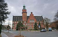
Reinickendorf town hall | ||
| ||
 Wittenau | ||
Location of Wittenau in Reinickendorf district and Berlin 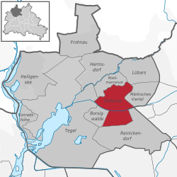 | ||
| Coordinates: 52°36′00″N 13°20′00″E / 52.60000°N 13.33333°ECoordinates: 52°36′00″N 13°20′00″E / 52.60000°N 13.33333°E | ||
| Country | Germany | |
| State | Berlin | |
| City | Berlin | |
| Borough | Reinickendorf | |
| Founded | 1322 | |
| Area | ||
| • Total | 5.9 km2 (2.3 sq mi) | |
| Population (2012-4-24) | ||
| • Total | 22,696 | |
| • Density | 3,800/km2 (10,000/sq mi) | |
| Time zone | CET/CEST (UTC+1/+2) | |
| Postal codes | (nr. 1209) 13435, 13437, 13439, 13469 | |
| Vehicle registration | B | |

Wittenau is a German locality (Ortsteil) within the borough (Bezirk) of Reinickendorf, Berlin.
History
Originally named Dalldorf it was first mentioned in 1332.[1] In 1869 the city of Berlin had acquired land in the Dalldorf in order to build the Städtische Irrenanstalt zu Dalldorf (City-owned Madhouse at Dalldorf), today's Karl-Bonhoeffer-Nervenklinik (Karl Bonhoeffer mental home), between 1877 and 1879.[2] In the following years Dalldorf became the synonym for 'madhouse' in Berlin parlance.[3] Therefore, in 1903 Dalldorf applied at the Niederbarnim district commissioner for a new toponym, Wittenau after its late mayor Peter Witte, granted by the Prussian government with effect of 23 August 1905.[4] In 1920 Wittenau merged into Berlin by the Greater Berlin Act.
Wittenau's former neighbourhood Märkisches Viertel was elevated to locality status in 1999. Until 24 April 2012 Borsigwalde, now also a locality of its own, was part of Wittenau.[5]
Geography
Overview
Situated in the north-western suburb of Berlin, not too far from the forest and the lake of Tegel, it borders with the localities of Waidmannslust, Lübars, Märkisches Viertel, Reinickendorf, Borsigwalde and Tegel. Its eastern corner, in Schorfheidestraße,[6] is close to Wilhelmsruh, in Pankow district.
Subdivision
The locality is subdivided into 1 zone (Ortslage):
- Cité Foch
Transport
As urban railway, the locality is served by S-Bahn and U-Bahn. The stations located in the Ortsteil are Wittenau (S1 + S85 + U8 lines), Karl-Bonhoeffer-Nervenklinik (S25 + U8), Rathaus Reinickendorf (U8) and Eichborndamm (S25, partly in Tegel). Borsigwerke station (U6), situated in Tegel, is nearby Borsigwalde.
Wittenau is also served by A 111 motorway, at the exit n.5, named "Holzhauser Straße".
See also
- Rathaus Reinickendorf
References
- ↑ (German) Historical infos about Wittenau
- ↑ Michael Zaremba,Reinickendorf im Wandel der Geschichte, Berlin: be.bra, 1999, p. 99. ISBN 3-930863-63-4.
- ↑ Reinickendorf, Axel Reibe and Wolfgang Ribbe (eds.), Berlin: Colloquium, 1988, (=Geschichte der Berliner Verwaltungsbezirke; vol. 4), pp. 69seq. ISBN 3-7678-0714-9
- ↑ Gerd Koischwitz, Sechs Dörfer in Sumpf und Sand – Geschichte des Bezirks Reinickendorf von Berlin, Berlin: Der Nord-Berliner, 1984, pp. 81–92. No ISBN
- ↑ (German) Documents on www.berlin.de
- ↑ Source: "ADAC StadtAtlas - Berlin-Potsdam". ed. 2007 - page 121, - ISBN 3-8264-1348-2
External links
| Wikimedia Commons has media related to Wittenau. |
| |