Winslow, Arizona
| Winslow, Arizona | |
|---|---|
| City | |
|
Standin' on the Corner Park and mural | |
 Location in Navajo County and the state of Arizona | |
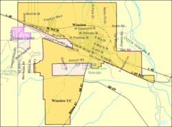 U.S. Census Map | |
 Winslow, Arizona Location in the United States | |
| Coordinates: 35°1′43″N 110°42′3″W / 35.02861°N 110.70083°WCoordinates: 35°1′43″N 110°42′3″W / 35.02861°N 110.70083°W | |
| Country | United States |
| State | Arizona |
| County | Navajo |
| Incorporated | 1900 |
| Government | |
| • Mayor | Robin R. Boyd |
| Area | |
| • Total | 12.3 sq mi (31.9 km2) |
| • Land | 12.3 sq mi (31.9 km2) |
| • Water | 0.0 sq mi (0.0 km2) |
| Elevation | 4,850 ft (1,478 m) |
| Population (2010)[1] | |
| • Total | 9,655 |
| • Estimate (2014)[2] | 9,604 |
| • Density | 773.1/sq mi (298.5/km2) |
| Time zone | MST (UTC-7) |
| ZIP code | 86047 |
| Area code(s) | 928 |
| FIPS code | 04-83930 |
| Website | City of Winslow |

Winslow (Navajo: Béésh Sinil) is a city in Navajo County, Arizona, United States. According to the 2010 census, the population of the city is 9,655.[1]
History
Winslow was named for either Edward F. Winslow, president of St. Louis and San Francisco Rail Road, which owned one half of the old Atlantic and Pacific Railroad, or Tom Winslow, a prospector who lived in the area.[3]
The last Harvey House (La Posada Hotel) opened in 1930. It was designed by Mary Colter. The hotel closed in 1957 and was used by the Santa Fe Railway for offices. The railroad abandoned La Posada in 1994 and announced plans to tear it down. It was bought and restored by Allan Affeldt[4] and it currently serves as a hotel.[5]
U.S. Route 66 was originally routed through the city. A contract to build Interstate 40 as a bypass north of Winslow was awarded at the end of 1977. I-40 replaced U.S. Route 66 in Arizona in its entirety.
Winslow achieved national fame in 1972 in the Eagles / Jackson Browne song “Take it Easy” which has the line “standing on a corner in Winslow, Arizona."
Demographics
| Historical population | |||
|---|---|---|---|
| Census | Pop. | %± | |
| 1890 | 363 | — | |
| 1900 | 1,305 | 259.5% | |
| 1910 | 2,381 | 82.5% | |
| 1920 | 3,730 | 56.7% | |
| 1930 | 3,917 | 5.0% | |
| 1940 | 4,577 | 16.8% | |
| 1950 | 6,518 | 42.4% | |
| 1960 | 8,862 | 36.0% | |
| 1970 | 8,066 | −9.0% | |
| 1980 | 7,921 | −1.8% | |
| 1990 | 8,190 | 3.4% | |
| 2000 | 9,520 | 16.2% | |
| 2010 | 9,655 | 1.4% | |
| Est. 2015 | 9,600 | [6] | −0.6% |
| U.S. Decennial Census[7] 2014 Estimate[2] | |||

As of the census[8] of 2000, there were 9,520 people, 2,754 households, and 1,991 families residing in the city. The population density was 773.1 people per square mile (298.6/km²). There were 3,198 housing units at an average density of 259.7 per square mile (100.3/km²). The racial makeup of the city was 40.8% White, 5.18% Black or African American, 23.47% Native American, 1.03% Asian, 0.09% Pacific Islander, 13.49% from other races, and 4.18% from two or more races. 28.84% of the population were Hispanic or Latino of any race.
There were 2,754 households out of which 40.3% had children under the age of 18 living with them, 50.2% were married couples living together, 16.0% had a female householder with no husband present, and 27.7% were non-families. 23.7% of all households were made up of individuals and 10.1% had someone living alone who was 65 years of age or older. The average household size was 2.86 and the average family size was 3.40.
In the city the population was spread out with 29.8% under the age of 18, 11.0% from 18 to 24, 31.1% from 25 to 44, 18.1% from 45 to 64, and 10.0% who were 65 years of age or older. The median age was 31 years. For every 100 females there were 122.3 males. For every 100 females age 18 and over, there were 134.6 males.
The median income for a household in the city was $29,741, and the median income for a family was $35,825. Males had a median income of $28,365 versus $20,698 for females. The per capita income for the city was $12,340. About 17.5% of families and 20.9% of the population were below the poverty line, including 26.9% of those under age 18 and 16.3% of those age 65 or over.
Geography and climate
Winslow is located at 35°1′43″N 110°42′3″W / 35.02861°N 110.70083°W (35.028482, −110.700782).[9] According to the United States Census Bureau, the city has a total area of 12.3 square miles (32 km2), all land.
Winslow experiences a dry, temperate arid climate (Köppen BWk), with a wide diurnal temperature variation year-round, averaging 32.7 °F (18.2 °C). Winters are cool and dry, while summers are hot, and bringing the largest portion of the annual precipitation, which is 6.99 inches (178 mm); snowfall averages 6.4 inches (16 cm) per season.
| ||||||||||||||||||||||||||||||||||||||||||||||||||||||||||||||||||||||||||||||||||||||||||||||||||||||||||||||||||||||||||||||||||||||||||||||||||||||||||
Education
Winslow is served by the Winslow Unified School District.
Three public elementary schools are located in the city limits: Bonnie Brennan Elementary School, Jefferson Elementary School, and Washington Elementary School. Winslow Junior High School and Winslow High School serve the city. Winslow also hosts the Little Colorado Campus of Northland Pioneer College.
Transportation

Winslow is served by Winslow-Lindbergh Regional Airport (IATA: INW, ICAO: KINW). Originally constructed by Transcontinental Air Transport, there is currently no commercial airline service here. The Winslow airport was designed by Charles Lindbergh, who stayed in Winslow during its construction. When it was built, it was the only all-weather airport between Albuquerque, New Mexico and Los Angeles, California.
The city is on BNSF Railway's Southern Transcon route which runs between Los Angeles, California, and Chicago, Illinois. It is also a crew change point for BNSF Railway. The city also has twice-daily Amtrak service at Winslow (Amtrak station) (one train eastbound and one westbound).
Interstate 40 runs just north of Winslow; the town is on the historic U.S. Route 66 in Arizona.
Main sights

The historic La Posada hotel has been beautifully restored. It is home to acres of flower and vegetable gardens, the museum of painter Tina Mion, and the Turquoise Room, a world class restaurant and martini bar.
The nearby Meteor Crater, sometimes known as the Barringer Crater and formerly as the Canyon Diablo crater, is a famous impact crater.
Standin' On The Corner Park is a park featuring murals depicting the famous "Girl my Lord in a flatbed Ford". Winslow also has an annual Standin' On The Corner street festival, traditionally held the last week of September.
The Painted Desert and Petrified Forest are about 60 miles east of Winslow. The Little Painted Desert is 18 miles north of Winslow.
Historical events
In the era of wood burning steam locomotives Winslow was a center for adding water and fuel for the trains. All the passengers could disembark and have a meal at La Posada since there would be enough time during the required stop. During the 1920s many celebrities chose to come west to Hollywood and when they stopped in Winslow a parade took place. The local paper has pictures of these special events.
Winslow also had a round house for repairing of those steam engines, which made Winslow an important stop for the rail road. Sadly, when the station at Barstow CA was given the engineering responsibility for the new diesel locomotives, Winslow began its slow decline. Company brass moved out and other employees needed for such repairs did also.
In 1949 when the Shah of Iran came to America and toured some sights, he chose to come to the Grand Canyon. His plane landed at the Winslow airport and they took land transport to get to the canyon. [11]
9-11 Remembrance Gardens
Winslow is also home to the 9-11 Remembrance Gardens, a memorial honoring those who lost their lives during the September 11 attacks. The memorial was constructed using two beams recovered from the wreckage of the World Trade Center towers in New York City.
The 9-11 Memorial in Winslow is a result of the efforts of Bill Herron and Councilwoman Dee Rodríguez, along with a committee, planning for a remembrance. There was news of beams from the Trade Center towers' wreckage being given away and the persons in charge of the wreckage were contacted and agreed to give Winslow beams of 14 and 16 foot length.
Walmart supplied the transportation to Winslow. A large number of citizens donated time and money to the erection of the memorial, which was in place and celebrated on the first anniversary of the event, September 11, 2002. The memorial is at the corner of Transcon Lane and old Route 66 near the Flying J Truck Stop.
Popular culture
Winslow was referenced in the popular 1972 song "Take It Easy" written by Jackson Browne and Glenn Frey and performed by the Eagles.[12] The city had suffered a loss of commerce when U.S. Route 66 was supplanted by Interstate 40, but the popularity of the song led to renewed attention for Winslow and a commercial renaissance.[13]
Media
Radio
- KINO – 1230AM
Television
Notable people
- Erika Alexander, actress
- Bill Engvall, comedian
- Michael Daly Hawkins, U.S. Attorney for Arizona; U.S. Circuit Judge [9th Circuit]
- Nick Hysong, gold medalist in pole vault at the 2000 Summer Olympic Games
- Richard Kleindienst, United States Attorney General under Richard Nixon
- Tommy Singer, a Navajo silversmith who specialized in chip-inlay jewelry
- Jay R. Vargas, Medal of Honor recipient during the Vietnam War
See also
- List of historic properties in Winslow, Arizona
- Homolovi Ruins State Park
- Standin' on the Corner Park
References
- 1 2 "American FactFinder". United States Census Bureau. Retrieved 2014-08-23.
- 1 2 "Population Estimates". United States Census Bureau. Retrieved July 11, 2015.
- ↑ Jeff Scott (2002-08-07). "History and information about Winslow, Arizona". Jeff.scott.tripod.com. Retrieved 2011-12-26.
- ↑ "La Posada: Masterpiece Saved From The Wrecking Ball". Payson Roundup. 2015-09-18. Retrieved 2016-04-12.
- ↑ Weiser, Kathy (March 2010). "Winslow, Arizona - Frozen in Time". Legends of America. Retrieved 13 July 2012.
- ↑ "Annual Estimates of the Resident Population for Incorporated Places: April 1, 2010 to July 1, 2015". Retrieved July 2, 2016.
- ↑ United States Census Bureau. "Census of Population and Housing". Retrieved August 23, 2014.
- ↑ "American FactFinder". United States Census Bureau. Retrieved 2008-01-31.
- ↑ "US Gazetteer files: 2010, 2000, and 1990". United States Census Bureau. 2011-02-12. Retrieved 2011-04-23.
- ↑ "NowData - NOAA Online Weather Data". National Oceanic and Atmospheric Administration. Retrieved 2013-07-19.
- ↑ "Arizona Republic November 27, 1949".
- ↑ Standin' on the Corner Park
- ↑ Mention the name Winslow, Arizona
External links
| Wikimedia Commons has media related to Winslow, Arizona. |
| Wikivoyage has a travel guide for Winslow (Arizona). |
| Cities |  | |
|---|---|---|
| Towns | ||
| CDPs |
| |
| Unincorporated communities |
| |
| Indian reservations |
| |
| Ghost towns | ||
| Footnotes | ‡This populated place also has portions in an adjacent county or counties | |