Wingmore

Coordinates: 51°10′35″N 1°07′45″E / 51.1763°N 1.1291°E
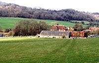
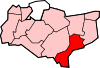
Wingmore is a small village between Canterbury and Folkestone in Kent, England.[1] It is situated in the Elham Valley approximately halfway between the larger villages of Elham and Barham on the B2065. It consists of a few cottages and farms. The population at the 2011 Census was included in the civil parish of Elham
References
External links
![]() Media related to Wingmore at Wikimedia Commons
Media related to Wingmore at Wikimedia Commons
This article is issued from Wikipedia - version of the 9/20/2016. The text is available under the Creative Commons Attribution/Share Alike but additional terms may apply for the media files.