Windsor, Pennsylvania
| Windsor, Pennsylvania | |
|---|---|
| Borough | |
|
Church on Main St. (SR 624) | |
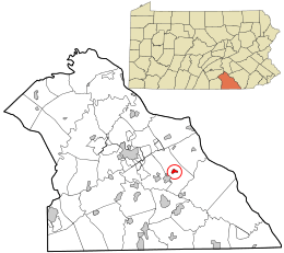 Location in York County and the state of Pennsylvania. | |
| Coordinates: 39°54′56″N 76°34′59″W / 39.91556°N 76.58306°WCoordinates: 39°54′56″N 76°34′59″W / 39.91556°N 76.58306°W | |
| Country | United States |
| State | Pennsylvania |
| County | York |
| Settled | 1830 |
| Incorporated | 1905 |
| Government | |
| • Type | Borough Council |
| Area | |
| • Total | 0.5 sq mi (1 km2) |
| Elevation | 725 ft (221 m) |
| Population (2010) | |
| • Total | 1,319 |
| • Density | 2,600/sq mi (1,000/km2) |
| Time zone | Eastern (EST) (UTC-5) |
| • Summer (DST) | EDT (UTC-4) |
| Zip code | 17366 |
| Area code(s) | 717 |

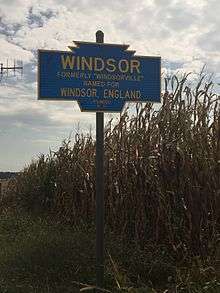
Windsor is a borough in York County, Pennsylvania, United States. It was established in 1905 and was named for Windsor, England. It was formerly named Windsorville. The population was 1,319 at the 2010 census.[1] In spring 2016, the Pennsylvania Department of Conservation and Natural Resources and York County's Marcellus Shale fun will provide $350,000 to make improvements at the Windsor baseball field. The project includes a handicap accessible bridge, wetland plants to capture rain runoff, new playground equipment and new bleachers.[2]
Geography
Windsor is located at 39°54′56″N 76°34′59″W / 39.91556°N 76.58306°W (39.915577, -76.582973).[3]
According to the United States Census Bureau, the borough has a total area of 0.5 square miles (1.3 km2), all of it land.
Demographics
| Historical population | |||
|---|---|---|---|
| Census | Pop. | %± | |
| 1910 | 697 | — | |
| 1920 | 854 | 22.5% | |
| 1930 | 1,009 | 18.1% | |
| 1940 | 1,108 | 9.8% | |
| 1950 | 1,126 | 1.6% | |
| 1960 | 1,029 | −8.6% | |
| 1970 | 1,298 | 26.1% | |
| 1980 | 1,205 | −7.2% | |
| 1990 | 1,355 | 12.4% | |
| 2000 | 1,331 | −1.8% | |
| 2010 | 1,319 | −0.9% | |
| Est. 2015 | 1,480 | [4] | 12.2% |
| Sources:[5][6][7] | |||
As of the census[6] of 2000, there were 1,331 people, 484 households, and 359 families residing in the borough. The population density was 2,676.3 people per square mile (1,027.8/km²). There were 525 housing units at an average density of 1,055.7 per square mile (405.4/km²). The racial makeup of the borough was 98.57% White, 0.53% African American, 0.08% Native American, 0.23% Asian, 0.15% from other races, and 0.45% from two or more races. Hispanic or Latino of any race were 0.60% of the population.
There were 484 households out of which 44.2% had children under the age of 18 living with them, 52.3% were married couples living together, 14.7% had a female householder with no husband present, and 25.8% were non-families. 18.8% of all households were made up of individuals and 8.7% had someone living alone who was 65 years of age or older. The average household size was 2.74 and the average family size was 3.09.
In the borough the population was spread out with 31.4% under the age of 18, 9.5% from 18 to 24, 33.2% from 25 to 44, 16.5% from 45 to 64, and 9.3% who were 65 years of age or older. The median age was 31 years. For every 100 females there were 92.3 males. For every 100 females age 18 and over, there were 89.8 males.
The median income for a household in the borough was $37,000, and the median income for a family was $40,057. Males had a median income of $30,492 versus $20,912 for females. The per capita income for the borough was $15,808. About 6.5% of families and 7.8% of the population were below the poverty line, including 7.7% of those under age 18 and 11.2% of those age 65 or over.
References
- ↑ "Race, Hispanic or Latino, Age, and Housing Occupancy: 2010 Census Redistricting Data (Public Law 94-171) Summary File (QT-PL), Windsor borough, Pennsylvania". U.S. Census Bureau, American FactFinder 2. Retrieved October 7, 2011.
- ↑ "Shale Money Used to Rehab Windsor Park and Creek". York Dispatch. Archived from the original on March 4, 2016. Retrieved October 10, 2015.
- ↑ "US Gazetteer files: 2010, 2000, and 1990". United States Census Bureau. 2011-02-12. Retrieved 2011-04-23.
- ↑ "Annual Estimates of the Resident Population for Incorporated Places: April 1, 2010 to July 1, 2015". Retrieved July 2, 2016.
- ↑ "Census of Population and Housing". U.S. Census Bureau. Retrieved 11 December 2013.
- 1 2 "American FactFinder". United States Census Bureau. Retrieved 2008-01-31.
- ↑ "Incorporated Places and Minor Civil Divisions Datasets: Subcounty Resident Population Estimates: April 1, 2010 to July 1, 2012". Population Estimates. U.S. Census Bureau. Retrieved 11 December 2013.
