Wilno Voivodeship (1926–39)
| Wilno Voivodeship Województwo wileńskie | |||||
| Voivodeship of Poland | |||||
| |||||
|
Coat of arms | |||||
 within the Second Republic of Poland (1938). | |||||
| Capital | Wilno | ||||
| Government | Voivodeship | ||||
| Voivode | |||||
| • | 1926–1931 | Władysław Raczkiewicz | |||
| • | May–-Sept 1939 | Artur Maruszewski | |||
| History | |||||
| • | Established | 20 January 1926 | |||
| • | Soviet invasion | 17 September 1939 | |||
| Area | |||||
| • | 1921 | 29,109 km2 (11,239 sq mi) | |||
| • | 1939 | 29,011 km2 (11,201 sq mi) | |||
| Population | |||||
| • | 1921 | 1,005,565 | |||
| Density | 34.5 /km2 (89.5 /sq mi) | ||||
| • | 1931 | 1,276,000 | |||
| Political subdivisions | 9 powiats | ||||

The Wilno Voivodeship (Polish: województwo wileńskie) was one of 16 Voivodeships in the Second Polish Republic, with the capital in Wilno. It was created in 1926 and populated predominantly by Poles with notable minorities of Belarusians, Jews and Lithuanians.
Wilno Voivodeship total area was 29,011 square kilometers, with the population of 1.276 million. Following the German and Soviet invasion of Poland and the reshaping of Europe, Poland's borders were redrawn at the insistence of Soviet leader Joseph Stalin at the Tehran Conference, and Wilno Voivodeship was incorporated in parts into the Lithuanian and Byelorussian Soviet Socialist Republics. The Polish population was forcibly resettled at the end of World War II. Since 1991, the former territory of the voivodeship is split between sovereign Lithuania and sovereign Belarus.
History
In 1920 following the Polish-Lithuanian War and the Żeligowski's Mutiny, Vilnius region became part of the Republic of Central Lithuania. In 1922, after a disputed election to the Vilnius Sejm, Central Lithuania was incorporated by parliament into the Second Polish Republic. From 6 April 1922 to 20 January 1926 the territory was known as the Wilno Land (ziemia wileńska). Wilno Voivodeship was created on 20 January 1926 from the territories of the Wilno Land. On 1 April 1927, Mołodeczno county[1][2] and [3] was created from parts of Vilejka (5 gminas), Ashmyany (1 gmina), Wołożyń (1 gmina) [4] and Stołpce (1 gmina) [4] countries. On 1 April 1929, Bienica gmina of Mołodeczno country was dissolved and was bounded to Wojstom gmina of Vilejka country. At same day, Kozłowszczyzna and Norzyca gminas of Postawy was dissolved and passed to Szarkowszczyzna and Głębokie gminas and of Dzisna country, Wierzchnie gmina of Dzisna was dissolved and passed to Postawy country, Jody gmina of Brasław country was dissolved and was passed to Szarkowszczyzna gmina of Dzisna country.[5] It was formed as the last of the Polish voivodeships in the interbellum (although the Sandomierz Voivodeship was to be created in late 1939).
Following the Soviet invasion in 1939, the Voivodeship was divided between the newly created Vileyka Voblast of the Belarusian SSR and independent Lithuania (from 1940 the Lithuanian SSR). This division wasn't internationally accepted. The Polish government-in-exile nominated Zygmunt Fedorowicz in 1942 as its representative for Wilno region. He was arrested by the NKVD in 1944.
Currently the former territory of Wilno Voivodeship is divided between the Vilnius and Utena counties in Lithuania and the Grodno, Minsk and Vitebsk Regions of Belarus.
Location
Wilno Voivodeship area was 29,011 square kilometers (which made it the fourth biggest Polish Voivodeship) and population (according to the 1931 Polish Census) - 1,276,000.
The Voivodeship was located in northeastern corner of the country, bordering Soviet Union to the east, Lithuania to the west, Latvia to the north, Nowogródek Voivodeship to the south and Białystok Voivodeship to the south-west. Landscape was flat and hilly in parts, with several lakes (such as Narocz, the biggest lake of interwar Poland). On January 1, 1937, forested was 21.2% of the area (with national average of 22.2%)
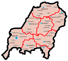
Towns and administrative division
Wilno Voivodeship was created after the territory of the Republic of Central Lithuania was merged with the so-called Wilno Area. In the years 1922–1939 it was divided into 9 powiats (counties):
| List of Counties with square area and population | ||||
|---|---|---|---|---|
| # | Name | CoA | Area | Population |
| 1 | Brasław county | |
4,217 km2 (1,628 sq mi) | 143,100 |
| 2 | Dzisna county | |
3,968 km2 (1,532 sq mi) | 159,900 |
| 3 | Mołodeczno county | |
1,898 km2 (733 sq mi) | 91,300 |
| 4 | Oszmiana county | |
2,362 km2 (912 sq mi) | 104,600 |
| 5 | Postawy county | |
3,050 km2 (1,178 sq mi) | 99,900 |
| 6 | Święciany county | |
4,017 km2 (1,551 sq mi) | 136,500 |
| 7 | Wilejka county | |
3,427 km2 (1,323 sq mi) | 131,100 |
| 8 | Wilno county | |
105 km2 (41 sq mi) | 195,100 |
| 9 | Wilno - Troki county | |
5,967 km2 (2,304 sq mi) | 214,500 * |
| * Wilno - Troki county was the biggest in the whole interwar Poland, bigger than the entire Autonomous Silesian Voivodeship | ||||
In 1931, the biggest city of the Voivodeship (and the biggest in northeastern Poland) was Wilno, with 195 100 inhabitants. Apart from this city, Voivodeship was sparsely populated and lacked more urban centers. All other towns were very small, none of them reached the population larger than 10 000 (as for 1931).
Population
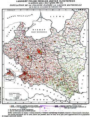
According to the Polish census of 1931 the Voivodeship was inhabited by 1,276,000 people. Majority of population was Polish (59.7% claimed Polish as their native tongue). Among minorities there were: Belarusians (22.7%), Russians (3.4%), Jews (8.5%) and Lithuanians (5.5%). The population density was 44 persons per km2 (second lowest in Poland, after Polesie Voivodeship).[6] The census has been criticized as inaccurate due to bias against the Belarusians and Lithuanians.[7][8]
Following the Polish territorial changes after World War II, a significant part of the Polish population was repatriated to the newly formed People's Republic of Poland as Wilno Voivodeship was split and incorporated into the Lithuanian and Byelorussian Soviet Socialist Republics.[9][10] Many encountered difficulties in the repatriation process, and where prevented from leaving.[9] The Polish population that remained in Lithuania were subject to Lithuanization and Sovietization policies.[9][10]
Industry and transport
Wilno Voivodeship was located in the so-called Poland “B”, which meant that it was still underdeveloped, apart from the city of Wilno. Large part of population was poor, with high level of illiteracy (in 1931, 29.1% was illiterate, with the national average of 23.1%). Railway network was scarce, with only few junctions - the most important one at Wilno, also at Molodeczno, Krolewszczyzna and Nowa Wilejka. Total length of railroads within Voivodeship's boundaries was 1,097 kilometres, which was only 3.8 per 100 square kilometres.
Voivodes
- Government delegates
- Władysław Sołtan, 4 February 1922 – 6 April 1922
- Walery Roman, 6 April 1922 – 29 August 1924
- Władysław Raczkiewicz, 29 August 1924 – 14 June 1925
- Olgierd Malinowski, 22 December 1925 – 25 May 1926 (acting)
- Voivodes
- Władysław Raczkiewicz, 18 May 1926 – 20 June 1931
- Stefan Seweryn Kirtiklis, 20 December 1930 – 20 June 1931
- Zygmunt Beczkowicz, 20 June 1931 – 27 January 1933
- Marian Styczniakowski, 27 January 1933 – 16 February 1933 (acting)
- Władysław Jaszczołt, 16 February 1933 – 13 October 1935
- Marian Styczniakowski, 14 October 1935 – 4 October 1935 (acting)
- Ludwik Bociański, 4 December 1935 – 19 May 1939
- Artur Maruszewski, 19 May 1939 – 18 September 1939
See also
References
- ↑ http://isap.sejm.gov.pl/DetailsServlet?id=WDU19250670472
- ↑ http://isap.sejm.gov.pl/DetailsServlet?id=WDU19260260158
- ↑ http://isap.sejm.gov.pl/DetailsServlet?id=WDU19270080062
- 1 2 http://isap.sejm.gov.pl/DetailsServlet?id=WDU19260450277
- ↑ http://isap.sejm.gov.pl/DetailsServlet?id=WDU19290140119
- ↑ "Drugi Powszechny Spis Ludności z dnia 9 XII 1931 r". Statystyka Polski (in Polish). D (34). 1939.
- ↑ Ghetto In Flames. KTAV Publishing House, Inc. GGKEY:48AK3UF5NR9. Retrieved 3 March 2011.
- ↑ Piotr Eberhardt (2003). Ethnic groups and population changes in twentieth-century Central-Eastern Europe: history, data, and analysis. M.E. Sharpe. pp. 199–202. ISBN 978-0-7656-0665-5. Retrieved 3 March 2011.
- 1 2 3 Timothy Snyder (2004). The reconstruction of nations: Poland, Ukraine, Lithuania, Belarus, 1569-1999. Yale University Press. pp. 92–. ISBN 978-0-300-10586-5. Retrieved 4 March 2011.
- 1 2 Dovile Budryte (2005). Taming nationalism?: political community building in the post-Soviet Baltic States. Ashgate Publishing, Ltd. pp. 147–. ISBN 978-0-7546-4281-7. Retrieved 4 March 2011.
Further reading
- Zygmunt Gloger (1900). Geografia historyczna ziem dawnej Polski (in Polish). Kraków: Spółka Wydawnicza Polska. ISBN 83-214-0883-4.
- (Polish) Maly Rocznik Statystyczny, Warszawa 1939 (Concise Statistical Year-Book of Poland, Warsaw 1939).
| City Voivodeship |  | |
|---|---|---|
| Land Voivodeships | ||
| Planned Voivodeships | ||
Coordinates: 54°40′50″N 25°16′12″E / 54.680455°N 25.269943°E