Wilmington Island, Georgia
| Wilmington Island, Georgia | |
|---|---|
| Census-designated place | |
|
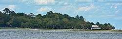
Wilmington Island as seen from Skidaway Island | |
 Location in Chatham County and the state of Georgia | |
| Coordinates: 32°0′12″N 80°58′31″W / 32.00333°N 80.97528°WCoordinates: 32°0′12″N 80°58′31″W / 32.00333°N 80.97528°W | |
| Country | United States |
| State | Georgia |
| County | Chatham |
| Area | |
| • Total | 9.5 sq mi (24.7 km2) |
| • Land | 8.2 sq mi (21.2 km2) |
| • Water | 1.3 sq mi (3.4 km2) |
| Elevation | 10 ft (3 m) |
| Population (2010) | |
| • Total | 15,138 |
| • Density | 1,846/sq mi (712.8/km2) |
| Time zone | Eastern (EST) (UTC-5) |
| • Summer (DST) | EDT (UTC-4) |
| ZIP code | 31410 |
| Area code(s) | 912 |
| FIPS code | 13-83168[1] |
| GNIS feature ID | 1867248[2] |
Wilmington Island is a census-designated place (CDP) in Chatham County, Georgia, United States. The population was 15,138 at the 2010 census.[3] It is part of the Savannah, Georgia Metropolitan Statistical Area. The communities of Wilmington Island form a large and affluent suburb of Savannah, where most residents work. The island lies east of Savannah between the town of Thunderbolt and the beach community of Tybee Island. Wilmington Island is home to the Wilmington Plantation condominiums.
Geography
Wilmington Island is located at 32°00′12″N 80°58′31″W / 32.003463°N 80.975224°W.[4]
According to the United States Census Bureau, the CDP has a total area of 9.5 square miles (24.7 km2), of which 8.2 square miles (21.2 km2) is land and 1.3 square miles (3.4 km2), or 13.94%, is water.[3]
Demographics
As of the census[1] of 2000, there were 14,213 people, 5,613 households, and 4,058 families residing in the CDP. The population density was 1,682.9 people per square mile (649.4/km²). There were 5,946 housing units at an average density of 704.0 per square mile (271.7/km²). The racial makeup of the CDP was 92.26% White, 3.93% African American, 0.12% Native American, 2.51% Asian, 0.04% Pacific Islander, 0.35% from other races, and 0.79% from two or more races. Hispanic or Latino of any race were 1.32% of the population.
There were 5,613 households out of which 35.8% had children under the age of 18 living with them, 60.6% were married couples living together, 8.7% had a female householder with no husband present, and 27.7% were non-families. 22.0% of all households were made up of individuals and 6.0% had someone living alone who was 65 years of age or older. The average household size was 2.53 and the average family size was 2.99.
In the CDP the population was spread out with 25.8% under the age of 18, 6.3% from 18 to 24, 33.6% from 25 to 44, 24.8% from 45 to 64, and 9.5% who were 65 years of age or older. The median age was 37 years. For every 100 females there were 93.9 males. For every 100 females age 18 and over, there were 91.7 males.
The median income for a household in the CDP was $58,689, and the median income for a family was $67,983. Males had a median income of $47,220 versus $31,836 for females. The per capita income for the CDP was $27,654. About 2.3% of families and 3.6% of the population were below the poverty line, including 2.5% of those under age 18 and 2.3% of those age 65 or over.
References
- 1 2 "American FactFinder". United States Census Bureau. Retrieved 2008-01-31.
- ↑ "US Board on Geographic Names". United States Geological Survey. 2007-10-25. Retrieved 2008-01-31.
- 1 2 "Geographic Identifiers: 2010 Demographic Profile Data (G001): Wilmington Island CDP, Georgia". U.S. Census Bureau, American Factfinder. Retrieved July 24, 2014.
- ↑ "US Gazetteer files: 2010, 2000, and 1990". United States Census Bureau. 2011-02-12. Retrieved 2011-04-23.
Municipalities and communities of Chatham County, Georgia, United States | ||
|---|---|---|
| Cities | 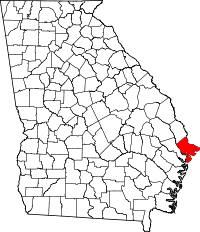 | |
| Towns | ||
| CDPs | ||
| Unincorporated communities | ||