Wild Rice River (North Dakota)
| Wild Rice River | |
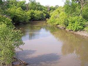 The Wild Rice River near Abercrombie in 2007 | |
| Country | United States |
|---|---|
| State | North Dakota |
| Source | |
| - location | Brampton Township, Sargent County |
| - elevation | 1,283 ft (391 m) [1] |
| - coordinates | 46°00′56″N 97°47′08″W / 46.01556°N 97.78556°W [2] |
| Mouth | Red River of the North |
| - location | near Frontier, Cass County |
| - elevation | 879 ft (268 m) [1] |
| - coordinates | 46°45′24″N 96°47′24″W / 46.75667°N 96.79000°WCoordinates: 46°45′24″N 96°47′24″W / 46.75667°N 96.79000°W [2] |
| Length | 251 mi (404 km) [3] |
| Basin | 2,233 sq mi (5,783 km2) [4] |
| Discharge | for near Abercrombie |
| - average | 104 cu ft/s (3 m3/s) [5] |
| - max | 9,540 cu ft/s (270 m3/s) |
| - min | 0 cu ft/s (0 m3/s) |
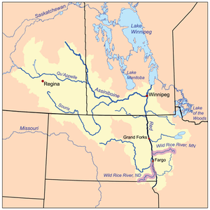 The Red River drainage basin, with the Wild Rice Rivers of North Dakota and Minnesota highlighted
| |
The Wild Rice River is a tributary of the Red River of the North, approximately 251 miles (404 km) long,[3] in southeastern North Dakota in the United States. Via the Red River, Lake Winnipeg, and the Nelson River, it is part of the watershed of Hudson Bay. The Wild Rice River drains an area of 2,233 square miles (5,780 km2) in the Red River Valley region. Its tributaries also drain a small part of northeastern South Dakota. Despite its length, it is a fairly small stream, flowing at an average rate of approximately 100 cubic feet per second (3 m³/s).
The river was so named for the former abundance of wild rice along its course.[6]
Course

The Wild Rice River rises as an intermittent stream in Brampton Township in southeastern Sargent County, approximately 6 miles (10 km) south of Cogswell. It initially flows generally eastwardly in a winding course through Sargent and Richland counties, through the Tewaukon National Wildlife Refuge and past the towns of Cayuga, Mantador and Great Bend. Past Great Bend, the river turns northward; from west of the city of Wahpeton it generally parallels the Red River in a winding channel at a distance of approximately 3 to 7 miles (5 to 11 km). It flows into the Red River in southeastern Cass County, approximately 3 miles (5 km) southeast of Frontier and 7 miles (11 km) south of Fargo.[7]
Flow rate
The United States Geological Survey operates a stream gauge on the river 3.2 miles (5.1 km) northwest of Abercrombie. Between 1932 and 2005, the annual mean flow of the river at the gauge was 104 cubic feet per second (2.9 m3/s). The river's highest flow during the period was 9,540 cubic feet per second (270 m3/s) on April 11, 1969. Readings of zero have also been recorded.[5]
At an upstream gauge near Rutland in Sargent County, the annual mean flow between 1960 and 1982 was 8.36 cubic feet per second (0.237 m3/s). A reading of 2,700 cubic feet per second (76 m3/s) was recorded on April 3, 1997.[8]
See also
References
Notes
- 1 2 Google Earth.
- 1 2 Geographic Names Information System.
- 1 2 U.S. Geological Survey. National Hydrography Dataset high-resolution flowline data. The National Map Archived 2012-04-05 at WebCite, accessed June 8, 2011
- ↑ Red River of the North, Reconnaissance Report.
- 1 2 Robinson, pp. 44-45
- ↑ Federal Writers' Project (1938). North Dakota, a Guide to the Northern Prairie State. WPA. p. 194. ISBN 978-1-62376-033-5.
- ↑ North Dakota Atlas & Gazetteer, pp. 52-53, 63-64
- ↑ Robinson, pp. 38-39
Sources
Books
Websites
- "Geographic Names Information System entry for Wild Rice River (Feature ID #1035247)". Geographic Names Information System. Retrieved 2007-06-15.
- "National Assessment Database: Assessment Data for the State of North Dakota Year 2004.". United States Environmental Protection Agency. pp. Western Wild Rice Watershed. Retrieved 2007-06-15.
- "Red River of the North, Reconnaissance Report: Wild Rice River". Defense Technical Information Center, United States Department of Defense. December 1980. Retrieved 2007-06-15.
- Robinson, S. M.; R. F. Lundgren; B. A. Sether; S. W. Norbeck; J. M. Lambrecht. "Water Resources Data North Dakota Water Year 2005, Volume 1 Surface Water." (PDF). United States Geological Survey. Retrieved 2007-06-15.
Software
- Google Earth elevations for Geographic Names Information System coordinates. Retrieved on 2007-06-15.