Whitfield, Manatee County, Florida
| Whitfield, Florida Whitfield Estates, Florida | |
|---|---|
| CDP | |
 Location in Manatee County and the state of Florida | |
 Whitfield, Florida Location in the United States | |
| Coordinates: 27°24′42″N 82°34′3″W / 27.41167°N 82.56750°WCoordinates: 27°24′42″N 82°34′3″W / 27.41167°N 82.56750°W | |
| Country |
|
| State |
|
| County | Manatee |
| Area | |
| • Total | 1.4 sq mi (3.7 km2) |
| • Land | 1.4 sq mi (3.6 km2) |
| • Water | 0 sq mi (0.1 km2) |
| Elevation | 16 ft (5 m) |
| Population (2000) | |
| • Total | 2,984 |
| • Density | 2,131.4/sq mi (806.5/km2) |
| Time zone | Eastern (EST) (UTC-5) |
| • Summer (DST) | EDT (UTC-4) |
| FIPS code | 12-77467[1] |
| GNIS feature ID | 1867236[2] |
Whitfield, locally known as Whitfield Estates, is a census-designated place (CDP) in Manatee County, Florida, United States. The population was 2,984 at the 2000 census. It is part of the Bradenton–Sarasota–Venice Metropolitan Statistical Area. It receives its mail from the Sarasota post office located in Sarasota County.
History
The Whitfield Estates Subdivision is a residential development in Whitfield, Manatee County, Florida, in the Sarasota metropolitan area, that was platted in 1925. Although the Whitfield Estates Subdivision is in Manatee County, Florida, not in the city of Sarasota, Florida (in Sarasota County) proper, residents use "Sarasota" as their mailing address and have associated themselves more with Sarasota, just to the south, rather than with Bradenton, a bit further to the north in Manatee County.[3]
The following districts and properties in the subdivision are listed on the National Register of Historic Places:
| Resource Name | Image | Address | Added |
| Whitfield Estates-Broughton Street Historic District |  | 7207, 7211, 7215, 7219 and 7316 Broughton Street | October 29, 1993 |
| John M. Beasley House |  | 7706 Westmoreland Drive | March 5, 1996 |
| Whitfield Estates-Lantana Avenue Historic District |  | 332-336 Lantana Avenue | March 8, 1997 |
| Austin House |  | 227 Delmar Avenue | February 5, 1998 |
| Reid-Woods House |  | 373 Whitfield Avenue | August 31, 2000 |
| Villa Serena Apartments | 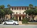 | 7014 Willow Street | September 29, 2000 |
| Paul M. Souder House |  | 242 Greenwood Avenue | November 2, 2000 |
| Stevens-Gilchrist House |  | 235 Delmar Avenue | August 17, 2001 |
Most of the above were listed in conjunction with the 1996 Whitfield Estates Subdivision Multiple Property Submission.
Geography
Whitfield is located at 27°24′42″N 82°34′3″W / 27.41167°N 82.56750°W (27.411620, -82.567518).[4]
According to the United States Census Bureau, the CDP has a total area of 1.4 square miles (3.6 km2), of which 1.4 square miles (3.6 km2) is land and 0.04 square miles (0.10 km2) (1.41%) is water.
Demographics
As of the census[1] of 2000, there were 2,984 people, 1,244 households, and 878 families residing in the CDP. The population density was 2,125.0 people per square mile (822.9/km²). There were 1,364 housing units at an average density of 971.3/sq mi (376.2/km²). The racial makeup of the CDP was 94.27% White, 2.98% African American, 0.13% Native American, 0.70% Asian, 0.07% Pacific Islander, 0.80% from other races, and 1.04% from two or more races. Hispanic or Latino of any race were 4.73% of the population.
There were 1,244 households out of which 21.9% had children under the age of 18 living with them, 58.0% were married couples living together, 9.1% had a female householder with no husband present, and 29.4% were non-families. 20.8% of all households were made up of individuals and 8.9% had someone living alone who was 65 years of age or older. The average household size was 2.40 and the average family size was 2.75.
In the CDP the population was spread out with 17.9% under the age of 18, 6.2% from 18 to 24, 26.9% from 25 to 44, 28.3% from 45 to 64, and 20.7% who were 65 years of age or older. The median age was 44 years. For every 100 females there were 96.1 males. For every 100 females age 18 and over, there were 94.3 males.
The median income for a household in the CDP was $51,536, and the median income for a family was $54,009. Males had a median income of $35,444 versus $24,375 for females. The per capita income for the CDP was $25,408. About 3.3% of families and 6.3% of the population were below the poverty line, including 8.3% of those under age 18 and 6.6% of those age 65 or over.
References
- 1 2 "American FactFinder". United States Census Bureau. Retrieved 2008-01-31.
- ↑ "US Board on Geographic Names". United States Geological Survey. 2007-10-25. Retrieved 2008-01-31.
- ↑ Mikki Hartig and Sherry Piland (July 1996). "National Register of Historic Places Multiple Property Documentation: Historic and Architectural Resources of Whitfield Estates Subdivision, Manatee County, Florida" (PDF). National Park Service. Retrieved September 20, 2016.
- ↑ "US Gazetteer files: 2010, 2000, and 1990". United States Census Bureau. 2011-02-12. Retrieved 2011-04-23.
Municipalities and communities of Manatee County, Florida, United States | ||
|---|---|---|
| Cities |  | |
| Town | ||
| CDPs | ||
| Unincorporated communities | ||
| Ghost town | ||
| Footnotes | ‡This populated place also has portions in an adjacent county or counties | |