Whitefish Bay
- There is also the village of Whitefish Bay, Wisconsin on Lake Michigan.
| Whitefish Bay | |
|---|---|
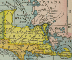 Chippewa County, Michigan and Whitefish Bay on the south shore of Lake Superior. | |
| Location | Chippewa County, Michigan[1] |
| Coordinates | 46°42′8″N 84°47′20″W / 46.70222°N 84.78889°WCoordinates: 46°42′8″N 84°47′20″W / 46.70222°N 84.78889°W |
| Type | Bay[1] |
| Surface elevation | 604 feet (184 m)[1] |
Whitefish Bay is a large bay on the eastern end of the southern shore of Lake Superior between Michigan and Ontario. It is located between Whitefish Point in Michigan, about 10 miles north of Paradise, and the St. Marys River at Sault Ste. Marie on the southeast. On the Ontario side, the bay is bordered by the more rugged, largely wilderness Canadian Shield. The international boundary runs through the bay, which is heavily used by shipping traffic northbound from and southbound to the Soo Locks. The Whitefish Point Light marks the entry of the bay, Ile Parisienne Light[2] is in the middle of the bay, and Point Iroquois Light lies near the mouth of the bay and the approach to the Soo Locks.
After the Soo Locks opened in 1855 and ship traffic increased on Lake Superior, Whitefish Bay was the site of numerous shipwrecks, often due to hazardous weather. The Whitefish Point Underwater Preserve was established to preserve many of the shipwrecks of Whitefish Bay for future generations of sports divers. Known wrecks include the ships Comet, John B. Cowle, Drake, Samuel Mather, Miztec, Myron, Niagara, John M. Osborn, Sagamore, Superior City, and Vienna.[3]
Whitefish Point is the home of a former United States Coast Guard station; Whitefish Point Lighthouse is the oldest active light on Lake Superior. Part of the lighthouse station houses the Great Lakes Shipwreck Museum. It holds artifacts from the above shipwrecks and has information on the notable wreck of SS Edmund Fitzgerald in 1975, in which all 29 crew were lost.
The Point is a popular place for rock collectors, ship watchers, and spectacular bird watching. Whitefish Point's land and water provides a natural corridor for birds that makes it a migratory route of world significance.[4] It is a designated Important Bird Area[5] where the Whitefish Point Bird Observatory[6] conducts important research.


See also
- Ile Parisienne
- Sandy Islands Provincial Park
- Shipwrecks of the 1913 Great Lakes storm
- South Shore (Lake Superior)
- Whitefish Bay National Forest Scenic Byway
References
- 1 2 3 U.S. Geological Survey Geographic Names Information System: Whitefish Bay
- ↑ Rowlett, Russ. "Lighthouses of Canada: Western Ontario". The Lighthouse Directory. University of North Carolina at Chapel Hill. Retrieved 22 November 2008.
- ↑ Whitefish Point Underwater Preserve
- ↑ "Whitefish Point - Important Bird Area". National Audubon Society 2010. Important Bird Areas in the U.S. Retrieved 2 October 2010.
- ↑ "Michigan IBA Blog". Retrieved 17 November 2008.
- ↑ "WPBO Research". Retrieved 17 November 2008.
External links
- Ile Parisienne Light photographs from Marinas.com
- Iroquois Light
- Great Lakes Shipwreck Museum
- Aerial image of Whitefish point from USGS via Microsoft Research Maps
- Whitefish Point Underwater Preserve
- Whitefish Point Bird Observatory