Whiteadder Reservoir
| Whiteadder Reservoir | |
|---|---|
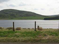 Sheep at the reservoir | |
| Location | East Lothian, Scotland |
| Coordinates | 55°51′50″N 2°33′23″W / 55.86389°N 2.55639°WCoordinates: 55°51′50″N 2°33′23″W / 55.86389°N 2.55639°W |
| Type | reservoir |
| Basin countries | United Kingdom |
| Surface area | 193 acres (0.78 km2) |
Whiteadder Reservoir is a reservoir in East Lothian, Scotland, UK, in the Lammermuir Hills, 11 miles (18 km) north west of Duns in the Scottish Borders, and five miles (8 km) south east of Garvald.
The reservoir was established in the late 1960s. The flooding ceremony was in May 1968. Millknowe Farm and Kingside School were flooded.
Whiteadder reservoir supplies East Lothian and Berwickshire, including Cockenzie Power Station on the northern coast of East Lothian, the Whiteadder Water flows out of the reservoir and the lowest tributary of the River Tweed which it enters at Berwick-on-Tweed.
Data
- Dam: 89 feet (27 m) high, and 600 feet (180 m) thick at the base.
- Capacity: 1,750 million US gallons (6,600,000 m3)
- Surface: 193 acres (0.78 km2)
Whiteadder Sailing Centre
Although the reservoir and the Outdoor Education Centre are in East Lothian, it has been managed by the Outdoor Education department of Scottish Borders Council for over 20 years. Through a partnership between East Lothian Council, Scottish Borders Council and Borders Sailing Club, funds were obtained for a major refurbishment, and the new Centre was opened in 2005.
Antiquities
Gamelshiel Castle ruin is not far from the reservoir, and the so-called "Packman's Grave" is also close by.
Photo gallery
 Whiteadder
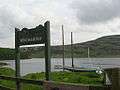 Sailing at Whiteadder
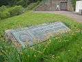 Reservoir Memorial plaque
 Whiteadder Water from the Reservoir