White Sands Space Harbor
| White Sands Space Harbor | |||||||||||||||||||
|---|---|---|---|---|---|---|---|---|---|---|---|---|---|---|---|---|---|---|---|
 | |||||||||||||||||||
| IATA: none – ICAO: none | |||||||||||||||||||
| Summary | |||||||||||||||||||
| Airport type | Military | ||||||||||||||||||
| Owner | US Air Force | ||||||||||||||||||
| Operator | NASA | ||||||||||||||||||
| Serves | White Sands Test Facility | ||||||||||||||||||
| Location | White Sands Missile Range | ||||||||||||||||||
| Elevation AMSL | 3,913 ft / 1,192 m | ||||||||||||||||||
| Coordinates | 32°56′35.67″N 106°25′10.31″W / 32.9432417°N 106.4195306°W | ||||||||||||||||||
| Runways | |||||||||||||||||||
| |||||||||||||||||||
White Sands Space Harbor (WSSH) was a Space Shuttle runway, a test site for rocket research, and the primary training area used by NASA for Space Shuttle pilots practicing approaches and landings in the Shuttle Training Aircraft and T-38 Talon aircraft. With its runways, navigational aids, runway lighting, and control facilities, it also served as a backup Shuttle landing site.[1] WSSH is a part of the White Sands Test Facility, and is located approximately 30 miles (50 kilometers) west of Alamogordo, New Mexico, within the boundaries of the White Sands Missile Range.
Runway facilities
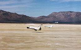
In 1976, NASA selected Northrup Strip as the site for shuttle pilot training. A second runway was added crossing the original north-south landing strip, and in 1979 both lakebed runways were lengthened to 35,000 ft (10,668 m), which includes 15,000 ft (4,572 m) usable runway with 10,000 ft (3048 m) extensions on either end, to allow the White Sands Space Harbor (WSSH) to serve as shuttle backup landing facility. While the Space Harbor was activated as a backup landing site for STS-116 due to poor weather conditions at both Edwards Air Force Base (high cross-winds) and Kennedy Space Center (clouds and rain), White Sands was only used for one landing of the space shuttle, that of the Space Shuttle Columbia on 30 March 1982 for STS-3.[2]
Launch complex
The McDonnell Douglas DC-X of the USAF Single Stage Rocket Technology (SSRT) program was launched 1993-96 at the harbor.[3][4]
References
Coordinates: 32°56′35.67″N 106°25′10.31″W / 32.9432417°N 106.4195306°W
NASA Space Shuttle (STS) | ||
|---|---|---|
| Parts |    | |
| Orbiters | ||
| Add-ons | ||
| Sites | ||
| Operations | ||
| Testing | ||
| Disasters | ||
| Support | ||
| Special | ||
| Derivatives |
| |
| Replicas | ||
| Related | ||