Whernside
| Whernside | |
|---|---|
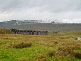 A snow-covered Whernside and Ribblehead Viaduct seen from Ribblehead | |
| Highest point | |
| Elevation | 736 m (2,415 ft) |
| Prominence | 408 m (1,339 ft) |
| Parent peak | No parent peak |
| Listing | Marilyn, Hewitt, Hardy, County Top, Nuttall |
| Coordinates | 54°13′40″N 2°24′12″W / 54.22764°N 2.40338°WCoordinates: 54°13′40″N 2°24′12″W / 54.22764°N 2.40338°W |
| Geography | |
 Whernside | |
| OS grid | SD738814 |
| Topo map | OS Landranger 98 |
Whernside is a mountain in the Yorkshire Dales and is the highest of the Yorkshire Three Peaks,[1] the other two being Ingleborough and Pen-y-ghent. It is the highest point in the ceremonial county of North Yorkshire [note 1] and the historic West Riding of Yorkshire with the summit lying on the county border with Cumbria.
In shape Whernside forms a long ridge, running roughly NNE to SSW. The mountain is 6.2 miles (10 km) north west of Ingleton and 6.2 miles (10 km) north of Horton-in-Ribblesdale.[2]
Routes
There is a right of way footpath running from the east at Ribblehead that heads north via Smithy Hill and Grain Ings before turning west to Knoutberry Haw and then south to Whernside itself. From the summit the right of way heads initially south, then steeply southwest down a stepped path to the area known as Bruntscar. If climbed as part of the Yorkshire Three Peaks Challenge (which is normally done anti-clockwise) Whernside will be climbed following the route up from Ribblehead to descend to Bruntscar.[3]
There are, however, other routes up/down the mountain which are not rights of way.
A path heads directly west from the triangulation pillar to reach the road that is Deepdale Lane near White Shaw Moss.
An alternative route heads directly north across Knoutberry Haw to pass Whernside Tarns and reaches the Craven Way at Boot of the Wold.
Following the southern descent for 0.76 miles (1.22 km), instead of turning steeply southeast towards Bruntscar a path continues south running adjacent the wall passing Combe Scar and West Fell to reach the limestone pavements at Ewe's Top.
Finally, 275 yards (251 m) south of the triangulation pillar an old route (partly fenced off) descends (initially very steeply) for 1.3 miles (2 km) to reach a road 275 yards (251 m) southwest of Winterscales Farm, this is the old route of the Three Peaks Challenge. Walkers should select this route with care as it is no longer maintained, boggy, badly eroded and requires extreme care over the steep ascent/descent. The current route of the Three Peaks fell race runs approximately 440 yards (400 m) north of this old ascent along open moor.
All paths are on open access land and make an interesting change from the right of way ascents/descents.
A walk solely around Whernside starting at the junction of the Blea Moor and Gauber roads near the Station Inn at Ribblehead, to the top of Whernside and back via the bridleway from Bruntscar via the farms at Broadrake, Ivescar, Winterscales and Gunnerfleet (or the footpath from Blea Moor Sidings) is a distance of roughly 8.5 miles (13.7 km).
General
On a clear day the views from the summit to the west can be spectacular, with views of the Lake District and Morecambe Bay, including (with the aid of binoculars) Blackpool Tower, some 40 miles (64 km) away.
Whernside lies about 2 miles (3 km) northwest of Ribblehead Viaduct on the Settle–Carlisle Railway.
Whernside is sometimes confused with the lower peak of Great Whernside 17 miles (27 km) away to the east of Whernside. The word "Whern" is believed to refer to querns (millstones) whilst "side" is derived from the Norse "sættr", meaning an area of summer pasture.
References
- ↑ "Powerful image for Whernside". Craven Herald & Pioneer. 15 October 2009. Retrieved 30 November 2016.
- ↑ "98" (Map). Wensleydale & Upper Wharfedale. 1:50,000. Landranger. Ordnance Survey. 2016. ISBN 9780319261965.
- ↑ "Whernside – a walk to the highest point in Yorkshire" (PDF). yorkshiredales.org.uk. Retrieved 30 November 2016.
Notes
- ↑ Mickle Fell in southern Teesdale is the highest point within the boundaries of the historic county of Yorkshire.
External links
- Computer generated summit panoramas Whernside index
- Photos of Whernside and surrounding area on geograph.org.uk
- Walk up Whernside from Ribblehead Viaduct
- Listing on Peakbagger.com
Marilyns of Northern England | ||
|---|---|---|
| 1. Northumberland |  | |
| 2. Northern Lakeland | ||
| 3. Western Lakeland | ||
| 4. Central and Southern Lakeland | ||
| 5. Eastern Lakeland | ||
| 6. North Pennines and Durham | ||
| 7. Northern Yorkshire Dales | ||
| 8. Southern Yorkshire Dales | ||
| 9. North York Moors to the Humber | ||
| 10. Forest of Bowland | ||