Wheatfield Road
| Wheatfield Road | |
|---|---|
|
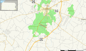
Map of Adams County in southern Pennsylvania with Wheatfield Road highlighted in red | |
| Route information | |
| Maintained by National Park Service | |
| Length: | 1.20 mi[1] (1.93 km) |
| Time period: |
1858 mapped by Howe[2] 1863 Battle of Gettysburg 1895 Gettysburg National Military Park 1933 National Park Service |
| Major junctions | |
| West end: |
|
| East end: |
|
| Location | |
| Counties: | Adams |
| Major cities: | Round Top (east) |
The Wheatfield Road is a Gettysburg Battlefield crossroad from the Peach Orchard east-southeastward along the north side of The Wheatfield (on the Peach Orchard-Devil's Den ridge),[3] north of the Valley of Death, and over the north foot of Little Round Top. In addition to modern tourist use, the road is notable for Battle of Gettysburg use and postbellum trolley use associated with the 1892-1896 US v. Gettysburg Electric Ry. case of the US Supreme Court.[4]
Route description
Wheatfield Road begins at an intersection with US 15 Bus. within Gettysburg National Military Park in Cumberland Township, where the road continues west as Millerstown Road. From here, it heads east-southeast as a two-lane undivided road, heading through fields in the park. The road continues into wooded areas with some fields, passing to the north of Little Round Top. Wheatfield Road comes to an end at an intersection with PA 134 in the community of Round Top, where the road continues east as Blacksmith Shop Road to Baltimore Pike.[1][5]
History
During the Battle of Gettysburg, the dirt Wheatfield Road was used by various Union and Confederate troops (e.g., Crawford's Third Division of Pennsylvania Reserves),[6] and Union troops deployed artillery westward to the Peach Orchard using the road.[3][7] In 1884, the Round Top Branch's wye with double spurs[8] and station was built at the east end of Wheatfield Road, and in 1894 the Gettysburg Electric Railway was laid along a west portion of the road (trolleys also crossed the east end near Round Top Station).[9] In 1895, the Commonwealth of Pennsylvania ceded jurisdiction of Wheatfield Road to the War Department,[10] and in 1900 two cast iron identification tablets were placed to label the road.[11]:'00 The Gettysburg Electric Railway tracks were removed from the Wheatfield Road in 1917 and the road was repaired in 1931.[12] The Wheatfield Road was resurfaced with asphalt west of Sykes Avenue in 1933,[13] and completed "from the Rosensteel pavilion to the Taneytown road" in 1940 by the McMillan Woods Civilian Conservation Corps camp.[14]
Junction list
The entire route is in Adams County.
| Location | mi[1] | km | Destinations | Notes | |
|---|---|---|---|---|---|
| Peach Orchard angle[3] | 0.0 | 0.0 | Continues west to Willoughby Run via Millerstown Road | ||
| Gettysburg National Military Park | McGilvery Artillery Avenue[15] | Southbound avenue[16] | |||
| 0.1 | 0.16 | Sickles Avenue | Northbound avenue | ||
| 0.21 | 0.34 | Wheatfield Road's Sickles Avenue section "constructed" in 1899[11]:'99 | |||
| 0.3 | 0.48 | Sickles Avenue | Southboun avenue "across Wheatfield")[11]:'96 | ||
| 0.6 | 0.97 | Ayres Avenue | Southboune avenue)[17] | ||
| Plum Run bridge 39°47′49″N 77°14′20″W / 39.7969°N 77.2390°W north of Valley of Death | |||||
| 0.7 | 1.1 | 1898 Crawford Avenue[11]:'98 | Crossroad | ||
| 1.0 | 1.6 | 1897 Sedgwick Avenue and Sykes Avenue[11]:'97[12] | Crossroad | ||
| Round Top | 1.2 | 1.9 | Continues east to Baltimore Pike via Blacksmith Shop Road | ||
| 1.000 mi = 1.609 km; 1.000 km = 0.621 mi | |||||
See also
 U.S. Roads portal
 Pennsylvania portal
 American Civil War portal
References
- 1 2 3 Google (June 7, 2011). "Overview Map of Wheatfield Road" (Map). Google Maps. Google. Retrieved June 7, 2011.
- ↑ Adams County Wall Map (Map). SimmonsGames.com mapviewer. 1858. Gettysburg Area inset. Retrieved 2011-06-08.
- 1 2 3 Hunt, General Henry J. The Second Day at Gettysburg. Retrieved June 7, 2011.
A cross-road connecting the Taneytown and Emmitsburg roads runs along the northern base of Devil's Den. From its Plum Run crossing to the Peach Orchard is 1100 yards. For the first 400 yards of this distance, there is a wood on the north and a wheat-field on the south of the road, beyond which the road continues for 700 yards to the Emmitsburg road along Devil's Den ridge, which slopes on the north to Plum Run, on the south to Plum Branch. [Rose Run] ... The angle at the Peach Orchard is thus formed by the intersection of two bold ridges, one from Devil's Den, the other along the Emmitsburg road
- ↑ Heebner, Chas, Esq; et al. (December 4, 1894). "Battlefield Commission vs The Trolley Company". Gettysburg Compiler. Retrieved April 20, 2011.
in the vicinity of the 'Peach Orchard' ... the [trolley] Company will very gladly agree to the changes desired, approximately as indicated on the blue prints hereto attached
- ↑ Adams County, Pennsylvania Highway Map (PDF) (Map). Pennsylvania Department of Transportation. 2011. Retrieved February 22, 2011.
- ↑ "The Pennsylvania Reserves at Gettysburg: Gen. Crawford's Contribution". Star and Sentinel. September 21, 1886. Retrieved 2010-02-21.
crossing the Taneytown road and skirting the Northern slope of [Little] Round Top, becomes a cross road from the Taneytown to the Emmitsburg road.
- ↑ http://www.gdg.org/Research/Authored%20Items/murrayalexander.htm
- ↑ Topographic map of Gettysburg (Map). c. 1900. Retrieved 2011-05-28.
- ↑ Map of the Battle Field of Gettysburg (Map). Cartography by Gettysburg National Park Commission. Julius Bien & Co. Lith. 1904. Retrieved June 7, 2011.
- ↑ Unrau, Harlan D. (1991). Administrative History of Gettysburg National Military Park and Gettysburg National Cemetery, Pennsylvania (PDF). Denver: National Park Service. p. 85. OCLC 24228617.
- 1 2 3 4 5 Gettysburg National Military Park Commission. "An Introduction to the Annual Reports of the Gettysburg National Military Park Commission to the Secretary of War". The Gettysburg Commission Reports. Gettysburg, PA: War Department. "Outside Wheatfield Rd (past Rose farm): On August 14 [1893] a Confederate avenue was surveyed, which was temporarily named the 'Outside Wheatfield avenue' beginning at the Emmitsburg road, 800 feet southwest of the crossroads at the Peach Orchard, running easterly to the lands of the Memorial Association, thence in a southeasterly direction by the lands of the Memorial Association, and terminating on a west line of the Crawford tract, near Devil's Den."
- 1 2 "Will Repair 22 Miles Of Battle Roads". Gettysburg Times. April 27, 1931. Retrieved June 7, 2011.
Wheatfield road from the Emmitsburg road to Sykes avenue, 5,250 feet.
- ↑ "To Resurface Field Roads". The Star and Sentinel. April 29, 1933. p. 1. Retrieved January 26, 2012.
- ↑ "New Stone Walk Helps Climb On Big Round Top". The Star and Sentinel. July 13, 1940. Retrieved June 7, 2011.
new walk nearly completed by C.C.C. enrollees on the steep slopes of Big Round Top ... C.C.C. enrollees also are at work on the Jones Battalion avenue east of the Harrisburg road about a mile north of Gettysburg
- ↑ Coddington, Edwin B. The Gettysburg Campaign:A Study in Command. p. 415. Retrieved June 6, 2011.
The central figure … near the Peach Orchard was Colonel Freeman McGilvery ... All four batteries of his First Volunteer Brigade ... twenty-two guns in all ... in the general area of the Peach Orchard. McGilvery had placed three of his batteries in line with the Fairfield crossroad facing south, and the fourth on higher ground west of the orchard in an angle formed by the crossroad and the Emmitsburg road.29
- ↑ McGilvery Artillery Ave. – Cast Iron Avenue Tablet (Plaque). Gettysburg National Military Park. 2005.
- ↑ Ayres Avenue - Cast Iron Avenue Tablets (Plaque). Gettysburg National Military Park. 2005.