Wetton, Staffordshire
| Wetton | |
 Wetton |
|
| OS grid reference | SK110555 |
|---|---|
| District | Staffordshire Moorlands |
| Shire county | Staffordshire |
| Region | West Midlands |
| Country | England |
| Sovereign state | United Kingdom |
| Post town | Ashbourne |
| Postcode district | DE6 6xx |
| Dialling code | 01335 |
| Police | Staffordshire |
| Fire | Staffordshire |
| Ambulance | West Midlands |
| EU Parliament | West Midlands |
|
|
Coordinates: 53°05′43″N 1°50′16″W / 53.095289°N 1.837913°W
Wetton is a village in the Peak District National Park, North Staffordshire, at the top of the east side of the Manifold Valley. The population recorded in the 2001 Census was 157. At the time of the 2011 Census the population was recorded under Ilam. This article describes the location, some of the main features of the village, and a number of places of historical or general interest in or near the village. These include Long Low, Wetton, a prehistoric burial site unique to England.
Because the post town is Ashbourne, Derbyshire, many sources of tourist information wrongly describe Wetton as being in Derbyshire.
Location
Wetton is a small village in the Staffordshire Peak District. It is about 2 miles west of Alstonfield and 8½ miles east of Leek. It stands high above the Manifold valley and contains mostly stone-built properties. The village has an inn, and a church, part of which dates back to the 14th century. The church is unusual in that it has an external staircase to its belfry.
Wetton village


Wetton village is primarily a collection of farmhouses, with the gaps filled in by cottages and a few larger houses. Towards the centre of the village are the village green, Ye Olde Royal Oak public house, the church, and the former vicarage.
The village gives its name to Wetton Mill (or Wettonmill), a nearby hamlet on the River Manifold, and Wetton Hill (grid reference SK104563), which are both in the care of the National Trust.
There are many burial chambers or mounds in the area, including those on Wetton Hill itself, at Wetton Low (1 km S of the village), and at Long Low, some 2 km SE of the village. There are also several campsites in the area offering access to the Manifold valley.
St Margaret's Parish Church
(1) on sketch plan.
The parish Church of St Margaret is the most obvious public building in the village. It is now in the Benefice of Alstonefield, in the Diocese of Lichfield. The present building was rebuilt in 1820, but the tower dates from the 14th century.[1]
Reading Room
(6) on sketch plan.
The Reading Room, by the churchyard gate opposite the village green, has not been in use for many decades. This may have been the "Club House" referred to by Rev. J B Dyson in his 1853 history of Methodism in the Leek Circuit as an early venue for Methodist meetings.[2]
School
(2) on sketch plan.
The village school had to close because of falling pupil numbers. The building is now in use as the Village Hall. The old village hall, situated on the road to Wetton Mill, was a corrugated iron construction which was unusable by the 1960s.[3] Children from Wetton, and from nearby Alstonefield (where the school in a village with a larger population has had the same change of use), now travel to Ilam or Warslow.
Methodist Chapel and Manse
(8) (9) on sketch plan.
The former Chapel and Manse are next to Town End Farm, which is the last farm on the north-east of the village.
The Old Police House
The village police house, with its cell, is now a residential home. It is between the village green and the former Methodist Chapel. Staffordshire Police rented the property from the Duke of Devonshire from 1876 for use as a Police Station. The cell was added in 1889, and the station was closed in 1941. The Charge Book is held in Staffordshire records office and this indicates that between 1890 and 1941 some 28 persons were detained overnight for various alleged offences. The adjoining property is the former schoolmistress's house.
Toe wrestling
(4) on sketch plan.
The Olde Royal Oak public house is famous for the annual toe wrestling competition.[4][5][6] It is said that this sport began there in 1976,[7][8] but was not raised to a championship event until 1993.[9] For many years the event took place at the Bentley Brook Inn in Ashbourne, Derbyshire, but it returned to Wetton in 2015.
History
The various tumuli point to prehistoric Stone Age and Bronze Age settlements. Items found in Thor's Cave and now in the museum at Buxton, are said to show evidence of early cave dwellers.
The remains of a Romano-British village was found in nearby Borough Fields by Samuel Carrington in the mid-18th century.
Wetton is not recorded in the Domesday Book, unlike neighbouring Alstonefield, Warslow and Stanshope, The earliest reference is to Wetindona in a document from the late 12th century.[10] The name derives from Old English "wet hill".
Industry
In modern times, the main industries are hill farming and tourism. However, the number of disused lead mines in the area point to a range of other industries. The most significant heavy industry was related to the construction of the Leek and Manifold Light Railway and mining at Ecton.
Methodism
When the Wetton and Longnor Wesleyan Methodist Circuit was formed in 1870, Wetton was chosen for the Manse. In 1932, the Circuit incorporated various Primitive Methodist Chapels. The Circuit was disbanded in 1969.[11] The first Wesleyan Methodist building was opened in 1828[12] The Primitive Methodists held meetings in Wetton, but did not establish a Chapel there. However, the Methodist Chapel at Ecton was Primitive Methodist, resulting from the industrial mission work from Ramsor and later the Leek Primitive Methodist Circuit.[13] After the completion of the railway in 1904, a building at Ecton became the Methodist Chapel there.
Places of interest
As a tourist destination, Wetton has a number of places of interest within the Parish.
Manifold Valley
The main tourist destination is the Manifold Valley. Several places may be noted (starting upstream).
Ecton
At the northern end of Wetton Parish, Ecton is most famous for the copper mine.
Swainsley
A little downstream from Ecton, this is the site of the only tunnel on the former railway. This was built because one of the owners of the railway lived there and did not want to be disturbed by passing trains.[14]
Wetton Mill
Wetton Mill was a water mill for grinding corn, and the remains of a mill stream, along with a grindstone, may still be seen. The mill is long since disused, but the Tea Room is popular with tourists.
Nan Tor, a cave with several mouths and the centre open to the sky, is a prominent landmark. It is a proposed candidate for the Green Chapel that features in the 14th-century chivalric romantic poem Sir Gawain and the Green Knight. This is due to the fact that the dialect in which the poem is written, closely resembles that of the local area. It also features characteristics that are similar to the Green Chapel which are described in the poem. Immediately downstream from the mill are several "swallow holes" where the River Manifold begins to flow underground to Ilam.
There is ample parking by the mill, on the site of the old halt, and the café is a popular stopping point for walkers using the Manifold Way and the many other rural walks that can incorporate parts of it.
Thor's Cave

Thor's Cave is a prominent landmark, both in the valley, and for some distance around. The cave is clearly visible from the moorland above Warslow. The main cave is near the top of a cliff overlooking the river. But the base has a number of small caves only just above river level, which may be reached when the river bed is dry.
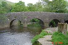
The Weags
The bridge where the road from Wetton to Grindon crosses the river is known as Weags Bridge. The valley sides are steep at this point, and the road has hairpin bends on both sides. As with much of the Manifold valley, the road is unsuitable for coaches.
Beeston Tor
Beeston Tor is a prominent rock face opposite the confluence of the River Hamps. This is popular with rock climbers.
Leek and Manifold Light Railway
Wetton was served by a railway station which was opened by the narrow gauge (2' 6") Leek and Manifold Valley Light Railway on 27 June 1904, whilst being entirely operated by the North Staffordshire Railway. The main purposes of the railway were (1) to provide more rapid transport for milk and dairy products from farms around the valley to customers in Leek and The Potteries, and (2) easier transport for the copper being mined at Ecton.
The village of Wetton was a good mile from the station, and the fact that the line followed the valley bottom whereas the settlements served by the railway were mostly on the hill-tops above was a contributary factor in its demise. The line closed in 1934, but in 1937 the route was reopened as the Manifold Way, a fully tarmacked 8-mile walk- and cycle-path which runs from Hulme End in the north to Waterhouses in the south.
Hills and other features
Wetton Hill
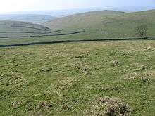
With a peak at 1221 feet above sea level, Wetton Hill is a prominent landmark. Views from the summit include Rugeley power station, some 25 miles south.
Wetton Low
Wetton Low is another peak, almost due south of the village. The name Low comes from its use as a burial ground, with several tumuli. There are also a number of disused lead mines in this area, some in the form of adits. At one time a wooded area of the valley side near the Low was designated as a nature reserve.
Long Low
Long Low is a Neolithic and Bronze Age burial site of a rare form, unique to Britain. It is about a mile south east of the village, with Wetton Low about mid-way from Long Low to the village.
References
- ↑ Wetton on A Church Near You web site
- ↑ Available on Rewlach Methodist history books archive
- ↑ Former resident and school pupil
- ↑ BBC Radio Stoke web site
- ↑ Off Track web site
- ↑ newspaper reports
- ↑ Origins and brief description on SportzFun
- ↑ comment on San Diego forum
- ↑ Derbyshire Peak District straying into Staffordshire
- ↑ Staffordshire Historical Collections 4th Series Volume IV. p. 31.
- ↑ Rewlach Methodist history Circuit history diagram
- ↑ Dyson, op. cit.
- ↑ Minutes of a Quarterly Meeting held at Leek 10 March 1862
- ↑ Lindsay Porter, Leek & Manifold Light Railway, ISBN 1-873775-20-2
Notes
- ^ The Wetton page of the Discover Derbyshire, Peak District web site (apparently claiming parts of Staffordshire as being across the border) has a very useful description of the village.
External links
| Wikimedia Commons has media related to Wetton, Staffordshire. |
- The village on the web
- GENUKI historical information
- Lichfield Diocesan web site
- Alstonefield Deanery web site
- Wetton Parish boundaries on ONS website
- Wetton page of ONS website

| Unitary authorities | |
|---|---|
| Boroughs or districts | |
| Major settlements | |
| Rivers | |
| Canals | |
| Topics | |