Westwood, Los Angeles
| Westwood | |
|---|---|
| Neighborhood of Los Angeles | |
|
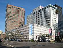
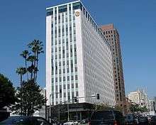
High-rise buildings line Wilshire Boulevard through the Westwood area | |
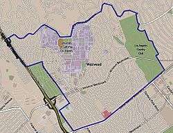 Westwood neighborhood as delineated by the Los Angeles Times. Mormon Temple in red. | |
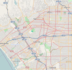 Westwood Location within Western Los Angeles | |
| Coordinates: 34°03′22″N 118°25′47″W / 34.05611°N 118.42972°W |

Westwood is a commercial and residential neighborhood in the northern central portion of the Westside region of Los Angeles, California. It is the home of the University of California, Los Angeles (UCLA).
The 2000 census found the forty-seven thousand people living in the neighborhood were generally young and moderately diverse ethnically, with a generally high level of income and education.
The neighborhood was developed after 1919, with a new campus of the University of California opened in 1926. Other attractions besides the UCLA campus include Westwood Village, with its historic motion picture theaters, restaurants and shopping, Westwood Village Memorial Park Cemetery and the Hammer Museum. Holmby Hills is considered one of the wealthiest residential areas in Los Angeles, and the Geffen Playhouse attracts theater-goers. A Mormon temple is also prominent.
There are several elementary schools and one middle school in the neighborhood.
Population
The 2010 U.S. census counted 47,916 residents in the 3.68-square-mile Westwood neighborhood—or 13,036 people per square mile, an average population density for the city. In 2008, the city estimated that the population had increased to 52,041. The median age for residents was 27, considered young for the city; the percentages of residents aged 19 to 34 was among the county's highest.[1]
The neighborhood was considered moderately diverse ethnically, with a high percentage of Asians and of whites. The breakdown was whites, 62.9%; Asians, 23.1%; Latinos, 7.0%; blacks, 2.0%; and others, 4.9%. Iran (23.5%) and Taiwan (7.3%) were the most common places of birth for the 31.3% of the residents who were born abroad—about the same percentage as in the city at large.[1]
The median yearly household income in 2008 dollars was $68,716, a high figure for Los Angeles. The percentages of households that earned $125,000 yearly and higher or that earned $20,000 or less were high for Los Angeles County. The average household size of two people was low for Los Angeles. Renters occupied 64.1% of the housing stock and house- or apartment owners held 35.9%. The percentages of never-married men and women were among the county's highest. In 2000 there were 309 families headed by single parents, a low percentage for the city. Five percent of the population had served in the military, a low figure for both the city and the county.[1]
Geography
According to the Westwood Neighborhood Council, the Westwood Homeowners Association, and the Los Angeles Times' Mapping L.A. project, Westwood's street and other boundaries are north, Sunset Boulevard; east, Beverly Hills city limits (to include the Los Angeles Country Club); south, Santa Monica Boulevard; and west, the San Diego Freeway (excluding the federal Veterans Administration grounds).[1][2]
Westwood is flanked on the north by Beverly Crest, on the east by Beverly Hills, on the southeast by Century City, on the south by West Los Angeles, on the west by Veterans Administration and Brentwood and on the northwest by Bel-Air.[3] The southern portion of Holmby Hills is also part of the Westwood district.[1]
History
Development
Westwood was developed on the lands of the historic Wolfskill Ranch, a 3,000-acre (12 km2) parcel that was purchased by Arthur Letts, the successful founder of the Broadway, and Bullock's department stores, in 1919. Upon Arthur Lett's death, his son-in-law, Harold Janss, vice president of Janss Investment Company, inherited the land and developed the area and started advertising for new homes in 1922.
The Los Angeles Times reported the news: "Westwood, the subdivision of the Wolfskill Ranch, 3,300 acres (13 km2) of scenic territory between the city and Santa Monica, is to be opened to homeseekers and investors today by the Janss Investment Company. The tract comprises approximately 1000 residential and business lots, situated west of the Los Angeles Country Club on Santa Monica Boulevard and the Rancho Country Club on Pico Boulevard."[4]
UCLA
Meanwhile, the Southern Branch of the University of California had been established on Vermont Avenue in Los Angeles, where enrollment expanded so rapidly that by 1925 the institution had outgrown the site. The selection of a new campus in the Westwood hills was announced on March 21, 1925. The owners of the estate, the Janss brothers, agreed to sell the property for approximately $1 million, less than one-third the land's value. Municipal bond measures passed by Los Angeles, Santa Monica, Beverly Hills and Venice provided for that amount. Proposition 10, a state bond measure passed that year, provided $3 million for new campus construction. Thus the predecessor of the University of California, Los Angeles, was established in Westwood and opened in 1926.
Gangs
| “ | The Los Angeles establishment reacted with horror. Newspapers and television headlined the story for days. Police patrols in Westwood tripled, and the L.A.P.D. assigned a 30-member antigang unit to capture Toshima's killer. | ” |
| — Time magazine[5] | ||
On January 30, 1988, gang violence brought nationwide attention to Westwood Village when Karen Toshima, a 27-year-old passer-by, was killed as she crossed a Village street in a shootout between gang members who had driven up from South Central Los Angeles .[5] Her killer, Durrell DeWitt Collins, 23, was sentenced to two concurrent terms of 27 years to life in prison. He would have been eligible for parole about 2003.[5][6] The episode led to the widespread impression that even affluent Westwood was not immune to the crime wave then ravaging Los Angeles.[7][8][9]
Westwood Village

.jpg)
Westwood Village was created by the Janss Investment Company, run by Harold and Edwin Janss and their father, Peter, in the late 1920s as an autonomous shopping district and headquarters of the Janss Company. Its boom was complemented by the boom of UCLA (which selected the Westwood Hills as its new home in 1925), developed as a shopping district for the residents of Westwood and the university.
Opening in 1929, the design was considered one of the nation's most well planned and beautifully laid out of commercial areas. Harold Janss had hired major architects and instructed them to follow a Mediterranean theme, with clay tile roofs, decorative Spanish tile, paseos, patios and courtyards. Buildings at strategic points, including theaters, used towers to serve as beacons for drivers on Wilshire Boulevard. Janss picked the first slate of businesses and determined their location in the neighborhood; the area opened with 34 businesses, despite the Great Depression, had 452 in 1939.[10]
The architectural style met a turning point in 1970, when a 24-story office building now known as Oppenheimer Tower was built in the neighborhood and the design of new buildings soon became a mishmash of styles. The Oppenheimer Tower was used for the primary location in the 1978 episode of Emergency!, The Steel Inferno. The neighborhood's popularity continued to rise, with commercial rents peaking in 1988. The area then suffered a major setback in the late 1980s, when gangs began to frequent the neighborhood and bother visitors; the problems culminated in January 1988 when a gang shootout resulted in the death of a 27-year-old bystander. The neighborhood's well known bookstores and some movie cinemas began closing with the advent of large chain stores, Amazon.com and multiplex theaters.[10]
By 1999, the Village was considered to be upscale economically,[6] and today it houses many small and large shops and restaurants. Historically, independent merchants have blamed poor sales on lack of parking; a city-owned garage, on Broxton Ave, provides two hours of free parking for patrons entering before 6 pm, and $3 flat rate parking from 6 pm to close (typically midnight on weeknights and 3 am on weekends). Parking is still cited as a problem.[10]
Geffen Playhouse
The Geffen Playhouse was built in 1929 at 10886 LeConte Avenue as the Masonic Affiliates Club, or the MAC, for students and alumni at UCLA. One of the first dozen structures built in Westwood Village, it was designed by architect Stiles O. Clements.[11][12]
Holmby Hills
Holmby Hills, Bel Air and Beverly Hills form the "Platinum Triangle" of Los Angeles. It is bordered by the city of Beverly Hills on the east, Wilshire Boulevard on the south and Bel Air on the north.[13][14]
LDS (Mormon) Temple

The Los Angeles California Temple, the second-largest temple operated by The Church of Jesus Christ of Latter-day Saints, is on Santa Monica Boulevard in Westwood. The temple grounds also includes a Visitors' Center open to the public and the headquarters for the Church's missionary efforts in Los Angeles. The church purchased the land for the temple from silent film star Harold Lloyd in 1937, but did not open the temple until 1956.
The temple grounds are also home to the Los Angeles Regional Family History Center (LARFHC), which is open to the public as well. It is the second-largest branch in the Family History Library system of the LDS Church, and contains more than 100,000 microfiche and 30,000 books.
-
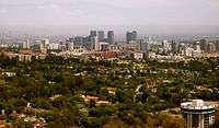
View of Westwood and surrounding areas, 2007
-

Aerial view of Westwood (center) and vicinity (3D computer generated image)
-
Hammer Museum, 2007
-

Westwood Park, 2012
Economy
Occidental Petroleum has its headquarters in Westwood.[15][16] Also located in the area is the headquarters for the Fox Sports Networks regional sports networks, as well as several other Fox-owned networks, including Fox Deportes and Fox College Sports.
Government and infrastructure
The Los Angeles County Department of Health Services SPA 5 West Area Health Office serves Westwood.[17]
Education
Sixty-six percent of Westwood residents aged 25 and older had earned a four-year degree by 2000, a high figure for both the city and the county. The percentages of residents of that age with a master's degree or higher was the third-highest in the county.[1][18]
The Los Angeles Unified School District operates public schools.
Schools in Westwood are:
- Fairburn Avenue Elementary School, LAUSD, 1403 Fairburn Avenue
- Warner Avenue Elementary School, LAUSD, 615 Holmby Avenue
- Sinai Akiba Academy, private elementary, 10400 Wilshire Boulevard
- Saint Paul the Apostle, private elementary, 1536 Selby Avenue
- Ralph Waldo Emerson Middle School, LAUSD, 1660 Selby Avenue
The zoned senior high school is University High School in West Los Angeles.[19]
UCLA Lab School Corinne A. Seeds Campus, formerly the Corinne A. Seeds University Elementary School and renamed in 2009, is the University of California, Los Angeles laboratory school.[20]
-

Fairburn Avenue School
-

Warner Avenue School

Parks and recreation
The Westwood Recreation Center is in Westwood. The facility includes barbecue pits, a lighted baseball diamond, lighted outdoor basketball courts, racquetball courts, a children's play area, a community room, an indoor gymnasium with weights, and a picnic table. The center also has Aidan's Place, which opened on December 5, 2001. The place, named after wheelchair-bound Aidan James, is a playground developed for joint use by handicapped and non-handicapped children.[21][22]
Holmby Park is also in Westwood.
Emergency services
Police
The Los Angeles Police Department operates the West Los Angeles Community Police Station at 1663 Butler Avenue, which serves the community.[23] Law enforcement for the UCLA campus is the responsibility of the UCLA Police Department, a division of the independent, statewide University of California Police Department.[24] As a state police agency, the UCLA PD has full law enforcement powers on and off campus.[24]
Fire and EMS
Fire and emergency medical services are provided by the Los Angeles Fire Department. UCLA Emergency Medical Services, a division of the UCLA Police Department, operates a Basic Life Support ambulance for the UCLA campus and supports LAFD on medical aid calls in the surrounding community.[25] UCLA also maintains a small fire suppression apparatus staffed by campus fire marshals that responds to university-owned properties and assists the outside community when requested to by LAFD.
See also
References
- 1 2 3 4 5 6 "Westwood," Mapping L.A., Los Angeles Times
- ↑ The Thomas Guide: Los Angeles County, 2004, pages 631 and 632
- ↑ Colored map, Mapping L.A., Los Angeles Times
- ↑ "Westwood Is Placed on the Market." Los Angeles Times. October 29, 1922. p. V9
- 1 2 3 Margaret Carlson, "The Price of Life in Los Angeles," Time, February 22, 1998
- 1 2 John Mitchell and John Kendall, "Toshima's Slayer Gets 27 Years to Life in Prison," Los Angeles Times, December 2, 1989, page 1
- ↑ Abigail Goldman, "A Wake-Up Call for Westwood Village: A Look Ahead," Los Angeles Times, August 25, 1997, pages B-1 and B-2
- ↑ Glionna, John M. (January 30, 1998). "A murder that woke up L.A.". Los Angeles Times. pp. A1.
- ↑ Reinhold, Robert B. (February 8, 1988). "Gang Violence Shocks Los Angeles". New York Times.
- 1 2 3 Martha Groves, Seeking shoppers in Westwood Village, Los Angeles Times, May 6, 2008, Accessed May 6, 2008.
- ↑ Geffen Playhouse - Westwood, retrieved 2007-02-22
- ↑ Mapquest
- ↑ H. May Spitz, A grander scale of life left intact, The Los Angeles Times, September 05, 2004
- ↑ King, Danny (September 1, 2003). "Projects move forward on Westwood's Golden Mile". Los Angeles Business Journal. p. 3.
- ↑ "Contact Us." Occidental Petroleum Corporation. Retrieved on December 8, 2011. "Corporate Headquarters 10889 Wilshire Boulevard Los Angeles, California 90024-4201 "
- ↑ Hsu, Tiffany. "Occidental's profit soars 53% to record high on surging oil prices." Los Angeles Times. April 25, 2008. C3. Retrieved on December 8, 2011. "Westwood-based Occidental Petroleum Corp."
- ↑ "About Us." Los Angeles County Department of Health Services. Retrieved on March 18, 2010.
- ↑ "Rankings," Mapping L.A.
- ↑ School Brochure (Archive). University High School. Retrieved on March 27, 2014. "The attendance area that Uni serves encompasses the neighborhoods of West Los Angeles, Brentwood, Bel-Air, and Westwood."
- ↑ "Famed UCLA elementary school gets new name." Los Angeles Times. March 10, 2009. Retrieved on March 29, 2014.
- ↑ "Westwood Recreation Center." City of Los Angeles. Retrieved on March 19, 2010.
- ↑ "Universally Accessible Playgrounds." City of Los Angeles. Retrieved on March 19, 2010.
- ↑ LAPD lapdonline.org
- 1 2 UCLA Police Department Uniformed Patrol Division – Overview of Patrol Operations
- ↑ UCLA EMS official website
External links
| Wikimedia Commons has media related to Westwood, Los Angeles. |
- Comments about living in Westwood
- Westwood crime map and statistics
- History of Westwood Village – Old Postcards
- Birds of Westwood – A guide to birds found on and near the UCLA campus
- Los Angeles Times, Real Estate section, Neighborly Advice column: "[Wilshire Corridor:] "Mini-Manhattan, just west of Los Angeles" (November 14, 2004)
- Los Angeles Times, Real Estate section, Neighborly Advice column: "[Westwood:] That Westside college town" (September 7, 2003)
 |
Bel-Air | Beverly Crest | Los Angeles Country Club | |
| Veterans Administration & Brentwood | |
Beverly Hills | ||
| ||||
| | ||||
| Sawtelle | West Los Angeles | Century City |
| Topics |  | |
|---|---|---|
| Government | ||
Coordinates: 34°03′22″N 118°25′47″W / 34.05611°N 118.42972°W