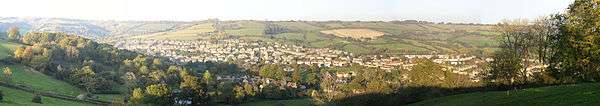
Weston, Bath
| Weston | |
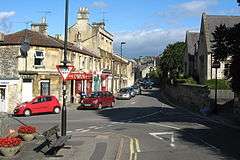 High Street, Weston |
|
 Weston |
|
| Population | 5,237 (2011.Ward)[1] |
|---|---|
| OS grid reference | ST728663 |
| Unitary authority | Bath and North East Somerset |
| Ceremonial county | Somerset |
| Region | South West |
| Country | England |
| Sovereign state | United Kingdom |
| Post town | BATH |
| Postcode district | BA1 |
| Dialling code | 01225 |
| Police | Avon and Somerset |
| Fire | Avon |
| Ambulance | South Western |
| EU Parliament | South West England |
| UK Parliament | Bath |
Coordinates: 51°23′46″N 2°23′30″W / 51.3962°N 2.3916°W
Weston is a suburb and electoral ward of Bath in England, located in the north west of the city.[2] Originally a separate village, Weston has become part of Bath as the city has grown, first through the development of Lower Weston in Victorian times and then by the incorporation of the village itself – also called Upper Weston – into the city with the siting of much local authority housing there in the period after World War II.
History
The earliest evidence of occupation comes from two Celtic Caddy spoons found in the village in 1825. There are believed to have been used as ceremonial anointing regalia.[3]
During the 10th century Weston had been divided into two estates. One, on the slopes of Lansdown was given by Edmund I to Aethelare in 946.[4] Weston was the birthplace of Saint Alphege who was born around 954.[5] The two manors are recorded in the Domesday Book of 1086 one held by Abbot Sewold and the other by Arnulf de Hesding.[6]
During the 12th and 13th centuries Weston had close ties with the monks of Bath Abbey and in the late 13th century the first vicar of Weston was appointed by the church.[7] Weston was part of the hundred of Bath Forum,[8][9] with a manorial court or Halmote being held in the Parish.[10] The land continued to be owned by the church and leased to tenants until the dissolution of the monasteries in 1539.[11] The estates in Weston then reverted to the king. In 1628 it was sold to the Corporation of London although the king continued to receive rent until 1671 when it was old to Sir Walter Long,[12] who was Member of Parliament for Bath from 1679 (the Habeas Corpus Parliament) to 1681. Following the Battle of Lansdowne in 1643, some of the defeated Roundheads took refuge in Weston.[13]
The village expanded during the 19th century with many areas being drained, the church being rebuilt and new schools established. The Georgian expansion of Bath included many houses being built in Weston and in 1834 Partis College was built. Developments continued into the Victorian era with Weston Park and Combe Park being developed.[14]
Parts of Weston are at risk of flooding due to old watercourses, sinks and springs in the area. West Brook now runs underground below the High Street, but this floods periodically. In 2013 the Weston Catchment alleviation scheme was announced to further protect the area.[15]
Services
Bath's main hospital, the Royal United Hospital, is on one of the roads from central Bath into Weston, and is generally considered to be in Weston. Strictly however, the hospital is in the neighbouring ward of Newbridge.
Weston has two primary schools, Weston All Saints C.E. V.C Primary School,[16] and St Mary's Catholic Primary School.[17] Lower Weston is served by Newbridge School; an earlier primary school called Weston St John's closed when the primary departments at Newbridge expanded in the 1970s.
Weston has a large amount of local amenities, including a recreation ground,[18] and youth club [Centre 69] and large amount of shops and services including a bakery, supermarket, post office, pet shop, pharmacy, 2 takeaways and 2 newsagents. There is also a greengrocer and 3 hair salons. The high street is dominated by a Tesco Express, which as of March 2014 is undergoing expansion to a Tesco Metro. The Tesco Express used to be a Somerfield, however switched to Tesco in 2009.
Weston Village is home to the 66th Bath Scout Group who meet on the High Street. Lower Weston is served by the 69th Bath Scout Group. Bath Scouts also own a campsite on the edge of Weston at Cleeve Hill. Rainbows, Brownies and Guides also meet within the village, along with a Boys' Brigade Company.
Religious sites
The village parish church is All Saints, originally founded no later than 1156. The current church dates from 1832 and was designed by the local architect John Pinch the younger, except for the tower which dates from the 15th century.[19] The Lower Weston parish church is St John's, barely a mile from Bath's city centre, and now in Kingsmead ward. There is also a Moravian church sited at the bottom of Lansdown Lane and the nearest Catholic church is St. Mary's on Julian Road.
Transport
Weston is served by three main bus routes providing connections towards Lower Weston, Newbridge, Bath City Centre, Combe Down, and Odd Down.
Service 14 operates up to every 9 minutes on weekdays; up to every 12 minutes on Saturdays; and up to every 20 minutes on Sundays on the following route:
- 14: Eastfield Avenue → Lansdown Lane → High Street, Weston → Royal United Hospital → Combe Park → Chelsea Road → Upper Bristol Road for Royal Victoria Park and interchange with other services → City Centre James Street West → City Centre Bus Station for interchange with bus and rail services → Wells Road → Bear Flat → Bloomfield Road → Frome Road → Odd Down Noads Corner
Service 1 operates up to every 30 minutes Monday - Saturday and up to every 60 minutes on Sundays between Upper Weston and Combe Down via High Street, Weston, Penn Hill Road, Newbridge Hill, Upper Bristol Road, Bath City Centre and Ralph Allen Drive.
Services 20A/C are city circular services and provide connections to many parts of Bath.
The Weston (Bath) railway station was at Lower Weston and closed in 1953, although the platform building and the stationmaster's house still exist. The station was on the Midland Railway line from Bath to Bristol and to the north, which itself closed in 1966.[20]
References
- ↑ "Weston". UKCrimeStats.com. Retrieved 2012-01-12.
- ↑ "Ward Maps". Bath & North East Somerset Council. Retrieved 10 March 2011.
- ↑ Hargood-Ash page 6
- ↑ Hargood-Ash pages 9-12
- ↑ Knowles pages 28, 241
- ↑ Hargood-Ash page 14
- ↑ Hargood-Ash pages 19-28
- ↑ Collinson page 97
- ↑ "Somerset Hundreds". GENUKI. Retrieved 9 September 2011.
- ↑ Hargood-Ash page 29
- ↑ Hargood-Ash page 39
- ↑ Hargood-Ash page 53
- ↑ Hargood-Ash page 84
- ↑ Hargood-Ash pages 100-110
- ↑ "2m flood relief project go-ahead in Bath". Bath Chronicle. 8 February 2013. Retrieved 10 February 2013.
- ↑ "Weston All Saints C.E. V.C Primary School". BANES. Retrieved 5 July 2008.
- ↑ "St Marys Catholic Primary School". BANES. Retrieved 5 July 2008.
- ↑ Charity Commission. Weston Recreation Ground, registered charity no. 304672.
- ↑ "All Saints Weston". Images of England. English Heritage. Retrieved 5 July 2008.
- ↑ Oakley
Bibliography
- Reverend John Collinson (1791). The History and Antiquities of the County of Somerset. 1. ISBN 978-1-171-40217-6.
- Hargood-Ash, Joan (2001). Two thousand years in the life of a Somerset village: Weston, Bath. Weston Local History Society. ISBN 0954164202.
- Knowles, David; London, Vera C. M.; Brooke, Christopher N.L. (2001). The Heads of Religious Houses, England and Wales, 940-1216 (Second ed.). Cambridge: Cambridge University Press. ISBN 0-521-80452-3.
- Oakley, Mike (2002). Somerset Railway stations. Wimborne: Dovecote Press. ISBN 978-1-904349-09-9.