West Newton, Pennsylvania
| West Newton, Pennsylvania | |
|---|---|
| Borough | |
|
East Main Street | |
 West Newton | |
| Coordinates: 40°12′34″N 79°46′09″W / 40.20944°N 79.76917°WCoordinates: 40°12′34″N 79°46′09″W / 40.20944°N 79.76917°W | |
| Country | United States |
| State | Pennsylvania |
| County | Westmoreland |
| Settled | 1788 |
| Incorporated | February 26, 1842 |
| Government | |
| • Type | Borough Council |
| • Mayor | Mary Popovich |
| Area | |
| • Total | 1.2 sq mi (3 km2) |
| • Land | 1.1 sq mi (3 km2) |
| • Water | 0.1 sq mi (0.3 km2) |
| Elevation | 777 ft (237 m) |
| Population (2000) | |
| • Total | 3,083 |
| • Density | 2,717.5/sq mi (1,049.2/km2) |
| Time zone | Eastern (EST) (UTC-5) |
| • Summer (DST) | EDT (UTC-4) |
| Zip code | 15089 |

West Newton, located 24.5 miles (39.4 km) southeast of Pittsburgh, is a borough in Westmoreland County in the U.S. state of Pennsylvania. Formerly, the manufacture of radiators and boilers were the chief industries. The population was 2,633 at the 2010 census.
History
The town traces its roots to 1788, when a group of American pioneers to the Northwest Territory led by Gen. Rufus Putnam traveled overland from Massachusetts and stopped at this location to build boats. They then set out down the Youghiogheny River to the Monogahela and Ohio Rivers, ending their journey and founding the town of Marietta, Ohio. Former names of the town are Simeral's Ferry (also, Sumrill’s Ferry) and Robbstown. Eighteen miners lost their lives in West Newton in 1901 at the Port Royal Mine.[1]
The Dick Building and Plumer House are listed on the National Register of Historic Places.[2]
Like many pioneer towns in Western Pennsylvania, West Newton earned its early historical relevance by playing a key role in the westward expansion of the United States. The Simerals were the first family to operate in this area and operated a small ferry on the Youghiogheny River halfway between Connellsville and McKeesport. A New Jersey native and whiskey rebel named Isaac Rob, laid out the town of West Newton, however, it was originally called "Robbstown". The town grew slowly as the community served as a trading outpost where the Old Glades Indian trail met the Youghiogheny River. West Newtons fortunes changed during the mid 19th century. River commerce increased with the construction of slack water dams in the 1830s. The introduction of the Pittsburgh, Connellsvile, and Markles Paper Mill provided early economic developments. Despite facing devastating fires, floods and tragic train wrecks in the 20th century, the people of West Newton preserved, continuing to develop both the infrastructure and economy of their community. As time progressed West Newton eventually transitioned into a bedroom community with a vast majority of residents working outside of the boroughs limits. The community saw new economic life blood, serving as a trail town from visitors around the world.
Geography
West Newton is located at 40°12′34″N 79°46′9″W / 40.20944°N 79.76917°W (40.209378, -79.769157).[3]
According to the United States Census Bureau, the borough has a total area of 1.2 square miles (3.1 km2), of which, 1.1 square miles (2.8 km2) of it is land and 0.1 square miles (0.26 km2) of it (8.13%) is water.
Demographics
| Historical population | |||
|---|---|---|---|
| Census | Pop. | %± | |
| 1850 | 771 | — | |
| 1860 | 949 | 23.1% | |
| 1870 | 992 | 4.5% | |
| 1880 | 1,475 | 48.7% | |
| 1890 | 2,285 | 54.9% | |
| 1900 | 2,467 | 8.0% | |
| 1910 | 2,880 | 16.7% | |
| 1920 | 2,645 | −8.2% | |
| 1930 | 2,953 | 11.6% | |
| 1940 | 2,765 | −6.4% | |
| 1950 | 3,619 | 30.9% | |
| 1960 | 3,982 | 10.0% | |
| 1970 | 3,648 | −8.4% | |
| 1980 | 3,387 | −7.2% | |
| 1990 | 3,152 | −6.9% | |
| 2000 | 3,083 | −2.2% | |
| 2010 | 2,633 | −14.6% | |
| Est. 2015 | 2,544 | [4] | −3.4% |
| Sources:[5][6][7] | |||
As of the census[6] of 2000, there were 3,083 people, 1,318 households, and 830 families residing in the borough. The population density was 2,717.5 people per square mile (1,053.4/km²). There were 1,410 housing units at an average density of 1,242.8 per square mile (481.8/km²). The racial makeup of the borough was 97.50% White, 1.14% African American, 0.16% Native American, 0.23% Asian, 0.16% from other races, and 0.81% from two or more races. Hispanic or Latino of any race were 0.42% of the population.
There were 1,318 households out of which 26.4% had children under the age of 18 living with them, 47.1% were married couples living together, 12.1% had a female householder with no husband present, and 37.0% were non-families. 34.4% of all households were made up of individuals and 20.4% had someone living alone who was 65 years of age or older. The average household size was 2.31 and the average family size was 2.98.
In the borough the population was spread out with 21.3% under the age of 18, 7.6% from 18 to 24, 27.6% from 25 to 44, 22.2% from 45 to 64, and 21.3% who were 65 years of age or older. The median age was 42 years. For every 100 females there were 86.4 males. For every 100 females age 18 and over, there were 83.5 males.
The median income for a household in the borough was $25,912, and the median income for a family was $41,063. Males had a median income of $36,386 versus $22,727 for females. The per capita income for the borough was $16,406. About 7.5% of families and 10.5% of the population were below the poverty line, including 13.3% of those under age 18 and 10.7% of those age 65 or over.
 Youghiogheny River at West Newton
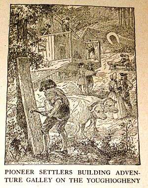 Pioneers building the flatboat, Adventure Galley, at Sumrill’s Ferry (present-day West Newton, Pennsylvania) during March 1788
Notable people
- Ray Luzier, drummer for Korn and David Lee Roth
- James L. Swauger, archaeologist
- Danny Taylor, Major League Baseball Outfielder
References
- ↑ "Port Royal No. 2 Mine Disaster June 10, 1901, Fitzhenry, Port Royal, Rostraver Twp., Westmoreland Co., PA". Retrieved 2016-01-01.
- ↑ National Park Service (2010-07-09). "National Register Information System". National Register of Historic Places. National Park Service.
- ↑ "US Gazetteer files: 2010, 2000, and 1990". United States Census Bureau. 2011-02-12. Retrieved 2011-04-23.
- ↑ "Annual Estimates of the Resident Population for Incorporated Places: April 1, 2010 to July 1, 2015". Retrieved July 2, 2016.
- ↑ "Census of Population and Housing". U.S. Census Bureau. Retrieved 11 December 2013.
- 1 2 "American FactFinder". United States Census Bureau. Retrieved 2008-01-31.
- ↑ "Incorporated Places and Minor Civil Divisions Datasets: Subcounty Resident Population Estimates: April 1, 2010 to July 1, 2012". Population Estimates. U.S. Census Bureau. Retrieved 11 December 2013.
External links
| Wikimedia Commons has media related to West Newton, Pennsylvania. |
- Downtown West Newton, Inc.
- https:/www.mywestnewton.com

| Counties |  Map of the Pittsburgh Tri-State with green counties in the metropolitan area and yellow counties in the combined area. | |
|---|---|---|
| Major cities | ||
| Cities and towns 15k-50k (in 2010) | ||
| Airports | ||
| Topics | ||
| ||