West Lancashire
For the constituency, see West Lancashire (UK Parliament constituency).
Coordinates: 53°33′43″N 2°49′37″W / 53.562°N 2.827°W
| Borough of West Lancashire | ||
|---|---|---|
| Borough | ||
| ||
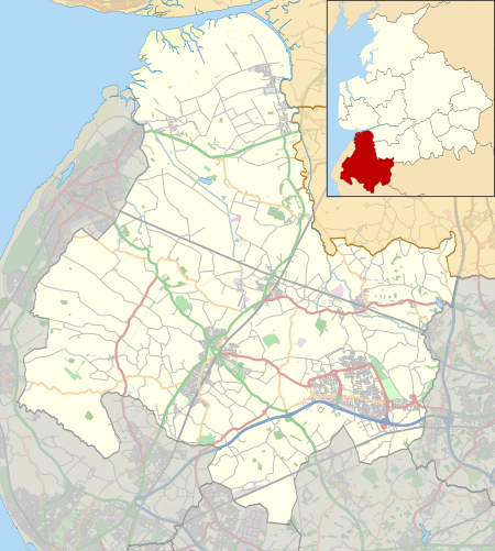
 Shown within non-metropolitan Lancashire | ||
| Sovereign state | United Kingdom | |
| Constituent country | England | |
| Region | North West England | |
| Ceremonial county | Lancashire | |
| Admin. HQ | Ormskirk | |
| Government | ||
| • Type | West Lancashire Borough Council | |
| • Leadership: | Leader & Cabinet | |
| • Executive: | Conservative | |
| • MPs: |
Rosie Cooper (Lab) (West Lancashire), Seema Kennedy (Con) (South Ribble) | |
| Area | ||
| • Total | 133.9 sq mi (346.8 km2) | |
| Area rank | 121st | |
| Population (mid-2014 est.) | ||
| • Total | 111,940 | |
| • Rank | Ranked 206th | |
| • Density | 840/sq mi (320/km2) | |
| Time zone | Greenwich Mean Time (UTC+0) | |
| • Summer (DST) | British Summer Time (UTC+1) | |
| ONS code |
30UP (ONS) E07000127 (GSS) | |
| Ethnicity | 98.5% White | |
| Website | http://www.westlancs.gov.uk/ | |
West Lancashire is a non-metropolitan district with the status of a borough in Lancashire, England. Its council is based in Ormskirk. The other town in the borough is Skelmersdale. The population of the District taken at the 2011 census was 110,685.[1] The district was formed in 1974 under the Local Government Act 1972, as a merger of Ormskirk and Skelmersdale and Holland urban districts along with part of West Lancashire Rural District and part of the former Wigan Rural District.
Administrative organisation
Crawford
Roby Mill

Civil parishes in West Lancashire
Political Composition (2016)-
| Party | Seats |
|---|---|
| Conservatives | 22 |
| Labour | 31 |
| Independent | 1 |
Unparished towns
The main towns of Ormskirk (including the village of Westhead) and Skelmersdale are unparished areas.
Parish councils
- 1. Aughton
- 2. Bickerstaffe
- 4. Burscough
- 5. Dalton
- 6. Downholland
- 7. Great Altcar
- 8. Halsall
- 9. Hesketh-with-Becconsall
- 10. Hilldale
- 11. Lathom
- 12. Lathom South
- 13. Newburgh
- 14. North Meols
- 15. Parbold
- 16. Rufford
- 17. Scarisbrick
- 18. Simonswood
- 19. Tarleton
- 20. Upholland
- 21. Wrightington
Parish meetings
There is a single parish meeting:
- 3. Bispham
Twin towns
West Lancashire is twinned with:
-
 Cergy-Pontoise, France
 -
 Erkrath, Germany
References
- ↑ "Non Metropolitan District Council population 2011". Retrieved 16 January 2016.
This article is issued from Wikipedia - version of the 11/27/2016. The text is available under the Creative Commons Attribution/Share Alike but additional terms may apply for the media files.