West Fork River
| West Fork River | |
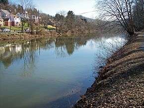
 The West Fork River in Enterprise in 1996 | |
| Country | United States |
|---|---|
| State | West Virginia |
| Counties | Upshur, Lewis, Harrison, Marion |
| Source | Confluence of Straight Fork and Whites Camp Fork |
| - location | near Rock Cave, Upshur County |
| - elevation | 1,309 ft (399 m) [1] |
| - coordinates | 38°51′08″N 80°21′32″W / 38.85222°N 80.35889°W [2] |
| Mouth | Monongahela River |
| - location | Fairmont |
| - elevation | 863 ft (263 m) [2] |
| - coordinates | 39°27′53″N 80°09′11″W / 39.46472°N 80.15306°WCoordinates: 39°27′53″N 80°09′11″W / 39.46472°N 80.15306°W [2] |
| Length | 103 mi (166 km) [3] |
| Basin | 881 sq mi (2,282 km2) [4] |
| Discharge | for Enterprise |
| - average | 1,160 cu ft/s (33 m3/s) (2005)[5] |
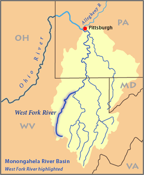 Map of the Monongahela River basin, with the West Fork River highlighted | |

The West Fork River is a principal tributary of the Monongahela River, 103 miles (166 km) long, in north-central West Virginia in the United States. Via the Monongahela and Ohio Rivers, it is part of the watershed of the Mississippi River, draining an area of 881 square miles (2,284 km²) on the unglaciated portion of the Allegheny Plateau.
Geography
The river is formed near the community of Rock Cave in southwestern Upshur County by the confluence of small headwaters tributaries known as Straight Fork[1] and Whites Camp Fork.[6] From this confluence the West Fork River flows north through Lewis, Harrison and Marion Counties, through the communities of Weston, West Milford, Clarksburg, Lumberport, Shinnston, Enterprise, Worthington, and Monongah to Fairmont, where it joins the Tygart Valley River from the west to form the Monongahela River. Among other tributaries, it collects Stonecoal Creek in Weston; Hackers Creek in southern Harrison County; Elk Creek in Clarksburg; and Simpson Creek and Tenmile Creek in northern Harrison County.[7]
The West Fork has a low gradient and is slow-moving throughout its course. It is locally popular for fishing, and is stocked with muskellunge by the West Virginia Division of Natural Resources. Other fish species in the river include carp; channel and flathead catfish; golden and rainbow trout; largemouth, smallmouth, and spotted bass; sauger; and walleye.[8]
Jackson's Mill was established along the river north of Weston around the year 1800 by Edward Jackson; his grandson, Thomas "Stonewall" Jackson lived there during much of his youth. The site has been operated as a 4-H facility since the 1920s.[9]
A walking trail parallels the river for 1.2 miles (2 km) in Veteran's Park in Clarksburg.[8] For much of its length between Clarksburg and Fairmont, the West Fork is paralleled by a pair of rail trails on the route of a mid-19th century line of the Baltimore and Ohio Railroad. The Harrison County Trail extends northward from Clarksburg, and the West Fork River Trail connects Shinnston to Fairmont. A long-term closure of the connection between the two trails is anticipated, due to the presence of hazardous waste at an industrial site near the community of Spelter in northern Harrison County.[10][11]
Dams and navigation
The West Fork River is not navigable by commercial barge traffic; it is classified by the West Virginia Division of Natural Resources as "recreationally navigable" for canoes and similar craft.[8] During the early history of the United States, the government of Virginia attempted to maintain commercial navigability on the river, chartering a company for that purpose in 1793 and requiring that dams for milling operations provide a chute for boats to pass downstream. Construction of a system of locks, dams, and chutes was begun by the Monongahela Navigation Company in 1817; the project was abandoned following damage by floods in 1824.[3]
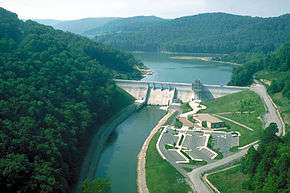
Three miles (5 km) south of Weston, the river is dammed by the U.S. Army Corps of Engineers to form Stonewall Jackson Lake. The project was authorized by the federal Flood Control Act of 1966 for flood control, improvement of water quality and water supply, improvement of habitat for fish and wildlife, hydropower, and recreation.[12] Construction of the dam was delayed by the opposition of local residents[3] and began in the mid-1980s at an ultimate cost of $208 million;[12] it became fully operational in 1988.[13] The dam is 95 feet (29 m) tall and forms a 2,650-acre (1,070 ha) lake, with a larger capacity during periods of flood.[12] Land along the lake is leased as a wildlife management area[14] and Stonewall Jackson Lake State Park.[15]
Between the years of 1905 and 1931, four small dams were constructed by the Clarksburg Water Board on a sixteen-mile (26 km) stretch of the river upstream (south) of Clarksburg, for the provision of local drinking water. While the dams in later years have come to be regarded as good fishing areas,[8] the Water Board is working with the U.S. Fish and Wildlife Service on plans to remove them.[16]
Variant names
The United States Board on Geographic Names settled on "West Fork River" as the stream's name in 1902. According to the Geographic Names Information System, the West Fork River has also been known historically as:[2]
- Muddy River
- West Branch
- West Fork
- West Fork Monongahela River
- West Fork of Monongahela River
- West River
See also
| Wikimedia Commons has media related to West Fork River. |
References
- 1 2 Geographic Names Information System. "Geographic Names Information System entry for Straight Fork (Feature ID #1547564)". Retrieved 2007-02-12.
- 1 2 3 4 Geographic Names Information System. "Geographic Names Information System entry for West Fork River (Feature ID #1548931)". Retrieved 2007-02-12.
- 1 2 3 Venable, Wallace (2006). "West Fork River". In Ken Sullivan (ed.). The West Virginia Encyclopedia. Charleston, W.Va.: West Virginia Humanities Council. p. 758. ISBN 0-9778498-0-5.
- ↑ West Virginia Department of Environmental Protection. "Watershed Atlas Project.". pp. West Fork River. Archived from the original on 2005-04-04. Retrieved 2007-02-26.
- ↑ United States Geological Survey. "USGS Surface-Water Annual Statistics for the Nation: USGS 03061000 West Fork River at Enterprise, West Virginia". Retrieved 2007-03-17.
- ↑ Geographic Names Information System. "Geographic Names Information System entry for Whites Camp Fork (Feature ID #1549092)". Retrieved 2007-02-12.
- ↑ DeLorme (1997). West Virginia Atlas & Gazetteer. Yarmouth, Maine: DeLorme. pp. 25, 36. ISBN 0-89933-246-3.
- 1 2 3 4 Jernejcic, Frank (March 1995). "Best of the West Fork". Wonderful West Virginia. West Virginia Division of Natural Resources. 59 (1): 2–4.
- ↑ Meador, Michael M. (2006). "Jackson's Mill." The West Virginia Encyclopedia. Ken Sullivan, editor. Charleston, WV: West Virginia Humanities Council. pp. 375-376. ISBN 0-9778498-0-5.
- ↑ Marion County Parks And Recreation Commission (2006). "Ralph S. LaRue / West Fork River Trail". Archived from the original on 2008-07-31. Retrieved 2007-02-12.
- ↑ West Virginia Rails-to-Trails Council (2002). "Harrison County Trail". Retrieved 2007-02-12.
- 1 2 3 United States Army Corps of Engineers. "Stonewall Jackson Lake". Retrieved 2007-02-12.
- ↑ Johnson, Skip (2006). "Stonewall Jackson Lake." The West Virginia Encyclopedia. Ken Sullivan, editor. Charleston, WV: West Virginia Humanities Council. p. 684. ISBN 0-9778498-0-5.
- ↑ West Virginia Department of Natural Resources (2003). "West Virginia Wildlife Management Areas". Archived from the original on 2008-04-15. Retrieved 2007-02-12.
- ↑ "Stonewall Resort/Stonewall Jackson Lake State Park". Retrieved 2007-02-12.
- ↑ "Clarksburg board plans to remove dams". Charleston Gazette. June 3, 2010. Archived from the original on June 3, 2010. Retrieved June 3, 2010.