West Fork Little Kanawha River
| West Fork Little Kanawha River | |
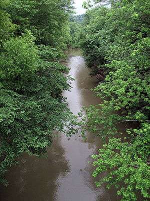 West Fork Little Kanawha River in Creston in 2009 | |
| Country | United States |
|---|---|
| State | West Virginia |
| Counties | Clay, Calhoun, Roane, Wirt |
| Tributaries | |
| - left | Left Fork West Fork Little Kanawha River |
| - right | Henry Fork |
| Source | |
| - location | southwest of Nebo, northern Clay County |
| - elevation | 1,178 ft (359 m) [1] |
| - coordinates | 38°37′06″N 81°03′14″W / 38.6184296°N 81.0539982°W [2] |
| Mouth | Little Kanawha River |
| - location | Creston, Wirt County |
| - elevation | 623 ft (190 m) [2] |
| - coordinates | 38°56′50″N 81°16′18″W / 38.9473052°N 81.2717844°WCoordinates: 38°56′50″N 81°16′18″W / 38.9473052°N 81.2717844°W [2] |
| Length | 48.1 mi (77 km) |
| Basin | 246 sq mi (637 km2) |
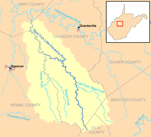 The West Fork Little Kanawha River and its watershed | |
The West Fork Little Kanawha River is a tributary of the Little Kanawha River, 48.1 miles (77.4 km) long,[3] in west-central West Virginia in the United States. Via the Little Kanawha and Ohio rivers, it is part of the watershed of the Mississippi River, draining an area of 246 square miles (640 km2)[4] in a rural region on the unglaciated portion of the Allegheny Plateau. By drainage area, it is the second-largest tributary of the Little Kanawha River, after the Hughes River.[4]
The West Fork rises southwest of the community of Nebo in northern Clay County and flows generally north-northwestward through Calhoun County and along a portion of Calhoun County's western boundary with Roane and Wirt counties, through the communities of Nebo, Stinson, Chloe, Minnora, Orma, Arnoldsburg, and Rocksdale, to its mouth at Creston in southeastern Wirt County, where it flows into the Little Kanawha River from the south. For most of its course upstream of Arnoldsburg, it is paralleled by West Virginia Route 16; for a short distance downstream of Arnoldsburg, it is paralleled by U.S. Route 33.[5]
Among the West Fork's tributaries are the Left Fork West Fork Little Kanawha River, which it collects at Orma; and the Henry Fork, which it collects along the boundary of Roane and Calhoun counties.[5]
According to the West Virginia Department of Environmental Protection, approximately 91% of the West Fork's watershed is forested, mostly deciduous. Approximately 8.8% is used for pasture and agriculture.[4]
Flow rate
At the United States Geological Survey's stream gauge on the West Fork at Rocksdale, downstream of the mouth of the Henry Fork, the highest recorded flow during the period 1928-2009 was 20,200 ft³/s (572 m³/s) on April 16, 1939. Periods of no flow were recorded at times during several years.[6]
See also
References
- ↑ Google Earth elevation for GNIS source coordinates. Retrieved on 2011-03-15.
- 1 2 3 Geographic Names Information System. "Geographic Names Information System entry for West Fork Little Kanawha River (Feature ID #1548928)". Retrieved 2011-10-11.
- ↑ United States Environmental Protection Agency. "Watershed Assessment, Tracking & Environmental Results: Assessment Summary for Reporting Year 2008, West Virginia, Little Kanawha Watershed". Archived from the original on 2011-10-13. Retrieved 2011-10-13.
- 1 2 3 West Virginia Department of Environmental Protection. "Little Kanawha River". Watershed Atlas Project. Archived from the original on 2005-04-04. Retrieved 2011-10-11. External link in
|work=(help) - 1 2 West Virginia Atlas & Gazetteer. Yarmouth, Me.: DeLorme. 1997. pp. 34, 44. ISBN 0-89933-246-3.
- ↑ "Water-Data Report 2009: 03154000 West Fork Little Kanawha River at Rocksdale, West Virginia" (PDF). United States Geological Survey. 2009. Retrieved 2011-10-11.