West Falkland
| West Falkland Isla Gran Malvina (Spanish) | |
|---|---|
| Island | |
|
West Falkland from Keppel Island | |
|
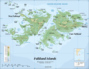
Location of West Falkland (red) in the Falkland Islands (red & white) | |
| Coordinates: 51°47′51″S 60°07′55″W / 51.79750°S 60.13194°WCoordinates: 51°47′51″S 60°07′55″W / 51.79750°S 60.13194°W | |
| Location | Atlantic Ocean |
| Archipelago | Falkland Islands |
| Area | |
| • Total | 4,532 km2 (1,750 sq mi) |
| Area rank | 2nd[a] |
| Population (2001)[1] | |
| • Total | 144 |
| • Rank | 2nd[b] |
| • Density | 0.032/km2 (0.082/sq mi) |
| Highest elevation | 700 m (2,300 ft) |
| Highest point | Mount Adam |
| Polity | Falkland Islands |
| Largest settlement | Port Howard |
|
a. ^ All islands in the Falkland Islands. b. ^ All inhabited islands in the Falkland Islands. | |


West Falkland (Spanish: Isla Gran Malvina) is the second largest of the Falkland Islands in the South Atlantic. It is a hilly island, separated from East Falkland by the Falkland Sound. Its area is 4,532 square kilometres (1,750 square miles), 37% of the total area of the islands.[2] Its coastline is 1,258.7 kilometres (782.1 miles) long.[2]
Population
The island has fewer than 200 people, scattered around the coastline. The largest settlement is Port Howard on the east coast, which has an airstrip. Other settlements include Albemarle, Chartres, Dunnose Head, Fox Bay, Fox Bay West, Hill Cove, Port Stephens, and Roy Cove, most of which are linked by road and also have airstrips and harbours. In 1986, the population was 265, in 2001, it had fallen to 144.[1]
Because West Falkland is outside Stanley or RAF Mount Pleasant on East Falkland it is considered part of the "camp", a Falklander term for the area outside the main settlement.
Geography and wildlife
West Falkland is hillier on the side closest to East Falkland. The principal mountain range, the Hornby Hills, runs parallel with Falkland Sound. Mount Adam, the highest hill in the islands, is 700 metres (2,300 ft) above sea level. [3] Formerly it was thought that Mount Robinson at 695 metres (2,280 ft) above sea level was the highest point. However, a later survey found that Mount Adam was higher. At this, the Argentines transferred the name Monte Independencia from Mount Robinson to Mount Adam.[4] The major industry on the island is sheep farming, while it is also known for its penguin and cormorant colonies. Fishing is also popular in the two main rivers, the Warrah and the Chartres.
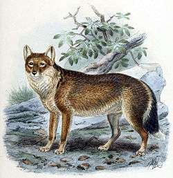
In the 19th century as today, indigenous land fauna was very scanty. A small wolf, the warrah, the loup-renard of Louis Antoine de Bougainville, is extinct, the last having been seen about 1875 on West Falkland. It is commemorated in the name of one of the island's rivers — the Warrah River — and the settlement of Fox Bay. Some herds of cattle and horses ran wild; but these were introduced by settlers as were the wild hogs, the numerous rabbits and the less common hares. All these have greatly declined in numbers, being profitably replaced by sheep.
The southernmost point of West Falkland is Cape Meredith, and the most south-westerly point is Calm Head. On the southerly side lie high cliffs with an abundance of seabirds. To the west are some white sandy beaches with beautiful clean water and rolling sand dunes with tall grass. Set just back from the top of the cliffs is a single wooden hut locally referred to as Uncle Tom's Cabin. The beaches are a habitat for elephant seals and are unpolluted save for the occasional piece of wreckage and the odd washed-up tree trunk.
Geology
Most of the layers of West Falkland and its surrounding islands are slightly inclined from the horizontal. This inclination shows different types of rocks in different places. The quartzites of Port Stephens and Stanley are more resistant than the arenaceous sediments of the formation at Fox Bay. The Hornby Mountains, near Falkland Sound have experienced tectonic forces of uplift and folding which has inclined the quartzite beds of Stanley to the vertical.
In West Falkland there are several dykes that cut the rocks of the western islands, but these dykes, unlike the previous ones, are chemically more unstable and have been eroded. The only indications of their existence are the aligned linear depressions. In the margins of these depressions there is evidence of contact baking or hornfels formation adjacent to the once molten basalt dyke.
History
Early explorers reported the remains of canoes on West Falkland but it is unclear whether it was a one way trip, or indeed if the canoes were not swept in from Patagonia.
Captain John Strong of the Welfare made the first recorded landing on either of the main islands (West and East Falkland) on 29 January 1690 at Bold Cove on the other side of the headland from Port Howard. He said:
- "Wednesday this morning we weighed and stood unto an harbour on ye west side and there came to ane anchor and sent our boat on shoar for fresh water and did kill abundance of geese and ducks but as far as wood there is none."
The lack of wood is somewhat surprising, as while there were no trees growing there, driftwood frequently washes up on Falkland beaches. This may be accounted for by the sheltered nature of Bold Cove. Strong named Falkland Sound, which gave its name to all the islands.
While the first recorded landing on the main islands of the Falklands was on West Falkland, it was settled remarkably late. In 1867 there were no settlers on West Falkland. The government issued a proclamation offering leases of grazing stations on very moderate terms and in 1868 all the available land was occupied.
Modern West Falkland is also home to two RAF Remote Radar Heads: Mount Alice, which is near Port Albermarle in the south of the island, and Mount Byron in the north.[5]
In early 2007 the Falkland Islands Government awarded a contract to supply an East-West ferry to Workboat Services Ltd.[6] The service runs between Port Howard and New Haven.
Falklands War
West Falkland saw some activity during the Falklands War in 1982; Fox Bay, Port Howard and Pebble Island were all occupied by Argentine troops during the hostilities and were subjected to occasional British naval bombardment and air attacks.
The most significant skirmish on West Falkland was perhaps the skirmish at Many Branch Point, near Port Howard.
Shag Cove saw several Argentine helicopters downed after British Harrier jump jets attacked them. The raid on Pebble Island has gone down in British Special Forces history.
References
- 1 2 "2001 Falkland Islands Census. Figure exclude persons aboard visiting vessels or the estimated number of people temporarily absent. It excludes serving military and their families, but not civilian staff at military bases.". 2001. Retrieved 5 March 2010.
- 1 2 Pichon, Hervé; Rolland, Nicolas; Orlova, Nadège; Lombardo, Stéphane (2002). "D2.1.1 Inventory Report". European Coastal Erosion database. European Commission. p. 122. Retrieved 6 October 2012.
- ↑ "Falklands.info Geography". web page. Retrieved 24 July 2010.
- ↑ "The Toponymy of the Falkland Islands as recorded on maps and in gazetteers (Para 14)". Permanent Committee on Geographic Names (Crown Copyright). 2006. Retrieved 5 March 2010.
- ↑ "RAF Today" (PDF). [United Kingdom] Ministry of Defence. February 2004. Retrieved 24 July 2010.
- ↑ "Workboat Services Ltd (Home page)". Retrieved 3 May 2010.
- General
-
 This article incorporates text from a publication now in the public domain: Chisholm, Hugh, ed. (1911). "article name needed". Encyclopædia Britannica (11th ed.). Cambridge University Press.