West Carroll Parish, Louisiana
| West Carroll Parish, Louisiana | |
|---|---|
|
The West Carroll Parish Courthouse in Oak Grove | |
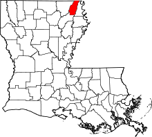 Location in the U.S. state of Louisiana | |
 Louisiana's location in the U.S. | |
| Founded | March 26, 1877 |
| Named for | Charles Carroll of Carrollton |
| Seat | Oak Grove, West Carroll Parish |
| Largest town | Oak Grove, West Carroll Parish |
| Area | |
| • Total | 361 sq mi (935 km2) |
| • Land | 360 sq mi (932 km2) |
| • Water | 0.9 sq mi (2 km2), 0.3% |
| Population | |
| • (2010) | 11,604 |
| • Density | 32/sq mi (12/km²) |
| Congressional district | 5th |
| Time zone | Central: UTC-6/-5 |


%2C_Oak_Ridge%2C_LA_IMG_7365.JPG)

West Carroll Parish (French: Paroisse de Carroll Ouest) is a parish located in the northeastern part of the U.S. state of Louisiana. As of the 2010 census, the population was 11,604.[1] The parish seat is Oak Grove.[2] The parish was founded in 1877.[3]
History
The original Carroll Parish, before it was divided into "West" and "East" segments, was named for Charles Carroll of Carrollton, Maryland, the only Roman Catholic signer of the Declaration of Independence and the last surviving signer of the document.
West Carroll Parish has a long history of inhabitants who predated the formation of the United States, possibly by thousands of years. For a complete history of West Carroll Parish, see Between the Rivers by Florence McKoin, Claitor’s Publishing Company of Baton Rouge.
On the south end of West Carroll Parish is Poverty Point, a nearly square-mile complex of ancient major earthwork semi-circles and radiating lanes, plus additional platform mounds. This is one of the largest Native American earthworks in North America. Archeologists have determined that the site was built in the Late Archaic period beginning about 1500 BCE, and it was the central trading grounds for the Poverty Point culture, people who called the lower Mississippi River Valley home. It has been referred to as the New York City of more than two millennia ago. Artifacts show trading reached to present-day Georgia and Great Lakes states such as Wisconsin. Later historic tribes in the area included the Choctaw and Chickasaw.
Though the area was explored by many French and Spanish in the 16th through 18th centuries, they did not establish permanent settlements, favoring areas on rivers with more direct access to the Gulf and major markets. After the United States' Louisiana Purchase of 1803, all of Northeast Louisiana was considered part of Ouachita Parish, including West Carroll. In 1807, a Methodist minister, Moses Floyd, settled on the west bank of the Bayou Macon. Later a trading post known as "Floyd" developed, and the village began to grow. It was located less than a mile from the Poverty Point site.
As the European-American population of Ouachita Parish continued to increase, the area was split into smaller parishes; in 1832 Carroll Parish was carved out of Ouachita by the state legislature. The parish seat is located in Lake Providence on the banks of the Mississippi River. Throughout the early part of the 19th century, the European-American population of the western portion of Carroll Parish continued to grow; its economy was based mainly on cotton production and timber. By 1855 the population had grown to the point where there were enough votes to move the parish seat west of the Bayou Macon to Floyd. This area had developed into a thriving trading post due to steamboat traffic on the Macon. In 1856 construction began on the new courthouse, which was finished in late 1857.
With the move of the parish seat came more professionals and tradesmen to Floyd, and the town grew exponentially. It was to become the typical frontier town with a hotel,post office, general store and saloons.
In January 1861 the Louisiana Legislature voted to secede from the Union and declare itself a free and sovereign state. Less than two months later, Louisiana joined the Confederacy. According to the book, Between the Rivers, this was the divide that would eventually lead to the creation of West Carroll Parish:
When the Confederate Flag flew over the court house in Floyd, it was saluted by nearly everyone, but not so with our neighbors across the river. Plantation|Planters to the east, either out of conviction to their consciences or to save their property, signed an oath of allegiance to the United States, thus bringing a rift among neighbors who were willing to lose everything including their lives, for the cause of the South; and, they felt very bitter toward any neighbor signing such an oath.
(Note: The oath was required after Union forces occupied Louisiana.)
There was little fighting in the area associated with the Civil War. Some historians attributed this to insurgent activity, such as the Quantrill Gang operating generally in Missouri; also significant was the isolated nature of the area and the vast swamps that surrounded Floyd. Frank James was said to come through with Quantrill in the winter of 1863-1864, on their way to and from Texas. In the early 1870s, Frank and his brother Jesse James robbed banks from Missouri to Texas, and were reported to have spent time in this area.
During the Reconstruction era, local leaders opposed those appointed by the federally appointed state government. Some people worked against the provision of rights to freedmen. In the 1870s, chapters of the White League developed throughout Louisiana, paramilitary groups that intimidated Republicans, repressed voting by freedmen, and supported white Democrats returning to power in the state legislature.
Federal troops were withdrawn from the state in March 1877. Soon after white Democrats regained power in the state legislature, they approved the creation of West Carroll Parish. Initially it had a population of 800 people and 200 families, both white and black. Cotton and timber continued to be the life-blood of the new parish, although areas dependent on agriculture in the late nineteenth and early twentieth century had economic difficulties. The parish had ten cotton gins and three sawmills, and steamboats continued to run Bayou Macon as the main hub of transportation.
Steamboat traffic on the Boeuf and Macon rivers dwindled due to the competition of railways constructed through the South. With the railroad, parish towns began to develop along the north-south road (La. 17). Among these were Pioneer, Forest, Oak Grove and Kilbourne. Closest to the parish seat and with a major sawmill, Pioneer grew rapidly.
In January 1909, Oak Grove was incorporated. Many of the parish’s prominent citizens, such as Leopold Lipp, saw its location where the North-South and East-West (La. 2) roads crossed. It was to become the economic center of the parish in the near future.
In 1915, an election was held to move the parish seat from Floyd to a town located on the railroad. The two towns competing for the honor were Oak Grove and Pioneer. With the largest population living in the south end of the parish, the people of Pioneer felt confident they would get the seat; but, the people of the north end of the parish gained the election of Oak Grove by a small margin. With the parish seat moved, Pioneer began to decline.
In 1916, construction began on the new courthouse, and before it was completed a hail storm and tornado devastated the town in late 1916, destroying the original theater, a large majority of the new courthouse, and many other buildings in town. In January 1917 the new courthouse was opened and so began of the modern era of Oak Grove. Its Main Street had businesses varying from general stores, drug stores, a modern theater, cafes, two banks and more.
The economy of the parish continued to be dominated by the timber and cotton industry. In the early part of the 20th century, Donald B. Fiske opened a state-of the art cotton gin and compress to complement his sawmill. It became one of the largest employers of the parish.
After World War II, the town and parish continued to prosper with new industry and business. In 1950, the most modern movie theatre in the South was opened by Fiske, and it is still in operation today. In this area, farmers began to cultivate sweet potatoes rather than cotton, as the textile industry moved out of the United States. A cannery was built along the railroad, and operated until near the end of the 20th century.
In the 1960s and 1970s, city growth continued, with the construction of a modern hospital, nursing home and the Wells Lamont garment factory. In 1969 the entrepreneur Shelton Ruffin built a pre-manufactured pole barn for personal use. Its style and construction quickly gained in popularity around the region, thus spurring the formation of Ruffin Building Systems. It is now one of the largest manufacturers of metal buildings in the South and ships buildings internationally. With the coming of the 1980s and the rise of the large department stores, business on Main Street began to decline. This historic district continues to remain vibrant with over 50 percent of its buildings occupied.
With the coming of the 21st century, entertainment and retail shopping have become major parts of the economy in West Carroll. In 2004 the Thomas Jason Lingo Community Center opened with a 1,000-seat auditorium; it has many live events each year. The Fiske Theatre has been renovated and returned to regular operation as a first-run movie theatre. Both of these venues bring families from all over Northeast Louisiana and Southeast Arkansas to the parish for entertainment. The opening of a Super Wal-Mart in 2006 has contributed to West Carroll becoming a regional retail hub.
Today agriculture is still king in West Carroll; the main crops are corn, rice, cotton, and sweet potatoes, but the largest employers are West Carroll Health Systems, West Carroll School Board, Ruffin Building Systems and Wal-Mart. West Carroll has five banking institutions to serve people’s financial needs.
Geography
According to the U.S. Census Bureau, the parish has a total area of 361 square miles (930 km2), of which 360 square miles (930 km2) is land and 0.9 square miles (2.3 km2) (0.3%) is water.[4]
Major highways
Adjacent counties and parishes
- Chicot County, Arkansas (north)
- East Carroll Parish (east)
- Richland Parish (south)
- Morehouse Parish (west)
National protected area
Law enforcement
The West Carroll Sheriff's Office provides full-time law enforcement for the parish and has seventeen full-time deputies. Jerry Philley serves as sheriff.
Demographics
| Historical population | |||
|---|---|---|---|
| Census | Pop. | %± | |
| 1880 | 2,776 | — | |
| 1890 | 3,748 | 35.0% | |
| 1900 | 3,685 | −1.7% | |
| 1910 | 6,249 | 69.6% | |
| 1920 | 8,857 | 41.7% | |
| 1930 | 13,895 | 56.9% | |
| 1940 | 19,252 | 38.6% | |
| 1950 | 17,248 | −10.4% | |
| 1960 | 14,177 | −17.8% | |
| 1970 | 13,028 | −8.1% | |
| 1980 | 12,922 | −0.8% | |
| 1990 | 12,093 | −6.4% | |
| 2000 | 12,314 | 1.8% | |
| 2010 | 11,604 | −5.8% | |
| Est. 2015 | 11,293 | [5] | −2.7% |
| U.S. Decennial Census[6] 1790-1960[7] 1900-1990[8] 1990-2000[9] 2010-2013[1] | |||
2010
Whereas according to the 2010 U.S. Census Bureau:
- 81.8% White
- 15.7% Black
- 0.4% Native American
- 0.2% Asian
- 0.0% Native Hawaiian or Pacific Islander
- 1.0% Two or more races
- 2.6% Hispanic or Latino (of any race)
2000
As of the census[10] of 2000, there were 12,314 people, 4,458 households, and 3,249 families residing in the parish. The population density was 34 people per square mile (13/km²). There were 4,980 housing units at an average density of 14 per square mile (5/km²). The racial makeup of the parish was 79.89% White, 18.88% Black or African American, 0.25% Native American, 0.13% Asian, 0.01% Pacific Islander, 0.43% from other races, and 0.41% from two or more races. 1.35% of the population were Hispanic or Latino of any race.
There were 4,458 households out of which 33.30% had children under the age of 18 living with them, 57.80% were married couples living together, 12.30% had a female householder with no husband present, and 27.10% were non-families. 24.80% of all households were made up of individuals and 13.80% had someone living alone who was 65 years of age or older. The average household size was 2.59 and the average family size was 3.09.
In the parish the population was spread out with 25.60% under the age of 18, 9.70% from 18 to 24, 26.50% from 25 to 44, 22.60% from 45 to 64, and 15.50% who were 65 years of age or older. The median age was 37 years. For every 100 females there were 102.10 males. For every 100 females age 18 and over, there were 99.50 males.
The median income for a household in the parish was $24,637, and the median income for a family was $31,806. Males had a median income of $28,211 versus $18,477 for females. The per capita income for the parish was $12,302. About 18.20% of families and 23.40% of the population were below the poverty line, including 30.80% of those under age 18 and 22.30% of those age 65 or over.
Politics
West Carroll Parish, unlike the smaller in population East Carroll Parish, is heavily Republican in presidential elections. In 2012, Mitt Romney polled 3,628 ballots (79.8 percent) of the vote, with 853 votes (18.8 percent) for U.S. President Barack Obama. The 80-19 split nearly parallels the racial composition of West Carroll. In majority African American East Carroll Parish, however, Obama won nearly 62 percent of the ballots.[11] In 2008, Obama received 878 votes (17.6 percent), compared to Republican U.S. Senator John S. McCain's 4,045 votes (81.1 percent).[12]
In 1992, the two major party presidential candidates virtually split West Carroll Parish. Republican U.S. President George H.W. Bush prevailed with 2,082 votes (40.7 percent) to Bill Clinton's 2,068 (40.4 percent). Ross Perot of Texas, running that year as an Independent, held another 771 votes (15.1 percent).[13] In 1988, Bush handily defeated Michael Dukakis in West Carroll Parish, 3,077 (64.1 percent) to 1,607 (33.5 percent).[14]
The last Democrat to win the presidential contest in West Carroll Parish was Jimmy Carter of Georgia in his 1976 defeat of U.S. President Gerald Ford, Jr.[15]
Education
West Carroll Parish public schools are operated by the West Carroll Parish School Board. The public school system consist of four high schools and five elementary schools that consistently rank at the top of the state in test scores and on the athletic field.
National Guard
The 921ST Engineer Company (Vertical) of the 528th Engineer Brigade resides in Oak Grove, Louisiana.
Communities
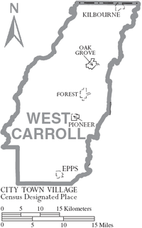
Towns
- Oak Grove (parish seat)
Villages
Prison
| Name | Address | Zip | Aged |
|---|---|---|---|
| West Carroll Parish Detention Center | 180 Capital Bank Dr, Epps, Louisiana | 71237 | 18+ |
Notable residents
- Roy A. Burrell (born 1952), Democratic member of the Louisiana House of Representatives for Caddo and Bossier parishes since 2004; native of West Carroll Parish[16]
- Lee Fletcher (1966–2009), Republican political consultant
- Vance McAllister (born January 1974), Republican candidate in Louisiana's 5th congressional district special election, 2013; in runoff with Republican State Senator Neil Riser on November 16, 2013, native of West Carroll Parish; businessman in Monroe
- Bill Myrick (born 1926), Country music figure in Odessa, Texas
- W. Spencer Myrick (1913–2002), member of both houses of the Louisiana State Legislature from West Carroll Parish
- J. Kelly Nix (born 1934), Louisiana education superintendent from 1976 to 1984
- Dave L. Pearce (1904–1984), the Democratic state commissioner of agriculture from 1952 to 1956 and again from 1960 to 1976, was reared in West Carroll Parish and graduated from the former high school in Pioneer.
- Tony Joe White (born 1943), an American singer-songwriter and guitarist best known for his 1969 hit "Polk Salad Annie"
- Henry L. Yelverton (1928–2009), Democrat state trial and appellate court judge based in Lake Charles, was reared in the Macon Ridge section of West Carroll Parish.
See also
References
| Wikimedia Commons has media related to West Carroll Parish, Louisiana. |
- 1 2 "State & County QuickFacts". United States Census Bureau. Retrieved August 18, 2013.
- ↑ "Find a County". National Association of Counties. Retrieved 2011-06-07.
- ↑ "West Carroll Parish". Center for Cultural and Eco-Tourism. Retrieved September 5, 2014.
- ↑ "2010 Census Gazetteer Files". United States Census Bureau. August 22, 2012. Retrieved September 2, 2014.
- ↑ "County Totals Dataset: Population, Population Change and Estimated Components of Population Change: April 1, 2010 to July 1, 2015". Retrieved July 2, 2016.
- ↑ "U.S. Decennial Census". United States Census Bureau. Retrieved September 2, 2014.
- ↑ "Historical Census Browser". University of Virginia Library. Retrieved September 2, 2014.
- ↑ "Population of Counties by Decennial Census: 1900 to 1990". United States Census Bureau. Retrieved September 2, 2014.
- ↑ "Census 2000 PHC-T-4. Ranking Tables for Counties: 1990 and 2000" (PDF). United States Census Bureau. Retrieved September 2, 2014.
- ↑ "American FactFinder". United States Census Bureau. Retrieved 2008-01-31.
- ↑ "West Carroll Parish: 2012 presidential election returns". staticresults.sos.la.gov. Retrieved November 11, 2012.
- ↑ "West Carroll Parish presidential election returns, November 4, 2008". staticresults.sos.la.gov. Retrieved November 18, 2012.
- ↑ "West Carroll Parish presidential election returns, November 3, 1992". staticresults.sos.la.gov. Retrieved November 18, 2012.
- ↑ "West Carroll Parish presidential election returns, November 8, 1988". staticresults.sos.la.gov. Retrieved November 18, 2012.
- ↑ Louisiana Secretary of State, 1976 presidential election returns by parish
- ↑ "Representative Roy A. Burrell". Louisiana Association of Business and Industry. Retrieved April 29, 2015.
 |
Chicot County, Arkansas | | ||
| Morehouse Parish | |
East Carroll Parish | ||
| ||||
| | ||||
| Richland Parish |
Municipalities and communities of West Carroll Parish, Louisiana, United States | ||
|---|---|---|
| Town | | |
| Villages | ||
Coordinates: 32°47′N 91°27′W / 32.79°N 91.45°W