West Ashton
| West Ashton | |
 Parish church of St John the Evangelist |
|
 West Ashton |
|
| Population | 737 (2011 census)[1] |
|---|---|
| OS grid reference | ST879557 |
| Civil parish | West Ashton |
| Unitary authority | Wiltshire |
| Ceremonial county | Wiltshire |
| Region | South West |
| Country | England |
| Sovereign state | United Kingdom |
| Post town | Trowbridge |
| Postcode district | BA14 |
| Dialling code | 01225 |
| Police | Wiltshire |
| Fire | Dorset and Wiltshire |
| Ambulance | South Western |
| EU Parliament | South West England |
| UK Parliament | South West Wiltshire |
| Website | Village site |
Coordinates: 51°18′00″N 2°10′30″W / 51.300°N 02.175°W
West Ashton is a village and civil parish in Wiltshire, England. It is about 2 miles (3.2 km) southeast of Trowbridge, near the A350 between Melksham and Yarnbrook which bypasses Trowbridge. The parish includes the hamlets of Dunge (grid reference ST 892 544), East Town (ST 893 557) and Rood Ashton (ST 886 560).[2]
Before the late 19th century, West Ashton was part of Steeple Ashton parish. Both were within the hundred of Whorwellsdown.[3]
The Anglican Church of St John the Evangelist was built in 1846 to designs of T.H. Wyatt with funding from Walter Long.[3] Its east window is a 1920 war memorial. In 1988 the church was designated as Grade II listed. It includes the family crypt and monuments to the Long family of Rood Ashton House.[4]
The village has a primary school, West Ashton Church of England (Aided) Primary School,[5] and a village hall.[6]
Rood Ashton House was a country house that had belonged for two centuries to the Long family. In February 1930, the house and 4,100 acres (17 km2) estate were put up for auction by Lord Long's executors, six years after his death. The estates were bought by a syndicate of his tenants, and in the 1960s the house was sold again. The new owner stripped the house of its assets, removing the lead roofing, internal panelling and fireplaces, and leaving it a roofless shell.[7] The north wing is the only surviving part of the house, and is a Grade II listed building.[8]
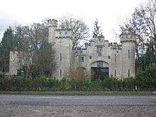
To the north of the village on the A350 is the folly known as Long's Park Castle, originally a lodge for Rood Ashton House. It is now used for holiday accommodation.[9]
References
- ↑ "Parish population 2011". Office for National Statistics. Retrieved 15 March 2015.
- ↑ "West Ashton, with 1890s map of parish". Wiltshire Community History. Wiltshire Council. Retrieved 13 June 2015.
- 1 2 "Victoria County History - Wiltshire - Vol 8 pp198-218 - Steeple Ashton". British History Online. University of London. Retrieved 13 June 2015.
- ↑ Historic England. "Church of St John the Evangelist, West Ashton (1262135)". National Heritage List for England. Retrieved 13 June 2015.
- ↑ "West Ashton Primary School". Retrieved 13 June 2015.
- ↑ "West Ashton Village Hall". Charity Commission. Retrieved 13 June 2015.
- ↑ "Steeple Ashton". British History Online. Retrieved 3 September 2016.
- ↑ "Rood Ashton House, West Ashton". British Listed Buildings. Retrieved 3 September 2016.
- ↑ "Longs Park Castle, West Ashton". Holiday Cottages. Retrieved 3 September 2016.
External links
![]() Media related to West Ashton at Wikimedia Commons
Media related to West Ashton at Wikimedia Commons