Wellen
| Wellen | |||
|---|---|---|---|
| Municipality | |||
 | |||
| |||
 Wellen Location in Belgium | |||
|
Location of Wellen in Limburg 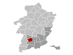 | |||
| Coordinates: 50°51′N 05°19′E / 50.850°N 5.317°ECoordinates: 50°51′N 05°19′E / 50.850°N 5.317°E | |||
| Country | Belgium | ||
| Community | Flemish Community | ||
| Region | Flemish Region | ||
| Province | Limburg | ||
| Arrondissement | Tongeren | ||
| Government | |||
| • Mayor | Els Robeyns (SPa) | ||
| • Governing party/ies | (SPa) | ||
| Area | |||
| • Total | 26.72 km2 (10.32 sq mi) | ||
| Population (1 January 2016)[1] | |||
| • Total | 7,374 | ||
| • Density | 280/km2 (710/sq mi) | ||
| Postal codes | 3830-3832 | ||
| Area codes | 012, 011 | ||
| Website | www.wellen.be | ||


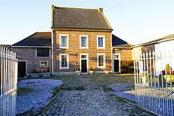
Wellen is a municipality located in the Belgian province of Limburg. On 1 January 2008, Wellen had a total population of 7,102. The total area is 26.72 km², giving a population density of 266 inhabitants per km2.
The municipality consists of the following sub-municipalities: Wellen , Berlingen, Herten and Ulbeek. Other population centres and hamlets include: Bos, Beurs, Kukkelberg, Langenakker, Oetersloven, Overbroek, Russelt, and Vrolingen.
History
Archaeological findings suggest the place was inhabited already during the Frankish period (5th to 7th century). Debris from the river Herk on that spot made fertile soil for farming. Mention of the name Wellene or Welnis doesn't occur until the second half of the 12th.
The name Wellen derives from the Middle Dutch "wellene", meaning "source" or "pit" or, alternately, from Latin terra Villina, "agricultural holding". Wellen was long associated with the abbey of Munsterbilzen, founded around 670.
References
- ↑ Population per municipality as of 1 January 2016 (XLS; 397 KB)
External links
- Official website
-
 Media related to Wellen at Wikimedia Commons
 |
Alken | | ||
| Sint-Truiden | |
Kortessem | ||
| ||||
| | ||||
| Borgloon |
