Weißenkirchen in der Wachau
| Weißenkirchen in der Wachau | ||
|---|---|---|
 | ||
| ||
 Weißenkirchen in der Wachau Location within Austria | ||
| Coordinates: 48°24′N 15°28′E / 48.400°N 15.467°ECoordinates: 48°24′N 15°28′E / 48.400°N 15.467°E | ||
| Country | Austria | |
| State | Lower Austria | |
| District | Krems-Land | |
| Government | ||
| • Mayor | Anton Bodenstein | |
| Area | ||
| • Total | 23.28 km2 (8.99 sq mi) | |
| Elevation | 224 m (735 ft) | |
| Population (1 January 2016)[1] | ||
| • Total | 1,474 | |
| • Density | 63/km2 (160/sq mi) | |
| Time zone | CET (UTC+1) | |
| • Summer (DST) | CEST (UTC+2) | |
| Postal code | 3610 | |
| Area code | 02715 | |
| Website | www.weissenkirchen-wachau.at | |

Weißenkirchen in der Wachau is a town in the district of Krems-Land in the Austrian state of Lower Austria.
Population
| Historical population | ||
|---|---|---|
| Year | Pop. | ±% |
| 1971 | 1,672 | — |
| 1981 | 1,601 | −4.2% |
| 1991 | 1,563 | −2.4% |
| 2001 | 1,494 | −4.4% |
References
- ↑ Statistik Austria - Bevölkerung zu Jahresbeginn 2002-2016 nach Gemeinden (Gebietsstand 1.1.2016) for Weißenkirchen in der Wachau.
| Wikivoyage has a travel guide for Weißenkirchen in der Wachau. |
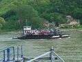 Ferry between Weißenkirchen and St. Lorenz before mooring at Weißenkirchen
 Parish church of Weißenkirchen
This article is issued from Wikipedia - version of the 10/29/2016. The text is available under the Creative Commons Attribution/Share Alike but additional terms may apply for the media files.