Wehl
| Wehl | |||
|---|---|---|---|
| |||
 | |||
| Coordinates: 51°57′38″N 6°12′38″E / 51.96056°N 6.21056°E | |||
| Country | Netherlands | ||
| Province | Gelderland | ||
| Municipality | Doetinchem | ||
| Area | |||
| • Land | 23.55 km2 (9.09 sq mi) | ||
| • Water | 0.02 km2 (0.008 sq mi) | ||
| Population (2007) | 6,876 | ||


Church: de Sint Martinuskerk
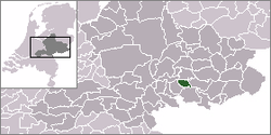
Wehl is a town in the eastern Netherlands, about 5 km west of Doetinchem.
Wehl was a part of Prussia until 1808, when it was joined to the Netherlands. In those years it was officially a part of Zeddam. Wehl became an independent municipality in 1813, when it was given back to Prussia; in 1816, it returned to the Netherlands. It remained an independent municipality until the municipal reorganization on 1 January 2005, when Wehl became part of the larger neighbouring municipality of Doetinchem.[1]
The former municipality also included the village of Nieuw-Wehl, 3 km to the west.
References
- ↑ Ad van der Meer and Onno Boonstra, "Repertorium van Nederlandse gemeenten", KNAW, 2006.
External links
Coordinates: 51°58′N 6°13′E / 51.967°N 6.217°E
This article is issued from Wikipedia - version of the 2/19/2016. The text is available under the Creative Commons Attribution/Share Alike but additional terms may apply for the media files.