Wegefarth County, Texas
| Wegefarth County, Texas | |
|---|---|
 Map of Greer and Wegefarth counties in 1874 | |
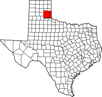 Location in the U.S. state of Texas | |
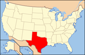 Texas's location in the U.S. | |
| Existed | 1873-1876 |
| Named for | Conrad Wegefarth |
Part of a series on the |
||||||||||||||
|---|---|---|---|---|---|---|---|---|---|---|---|---|---|---|
| History of Texas | ||||||||||||||
 | ||||||||||||||
| Timeline | ||||||||||||||
|
||||||||||||||
|
| ||||||||||||||
Wegefarth County was a Texas county established on June 2, 1873 from Bexar and Young territories and abolished on August 21, 1876. The county shared boundaries with Hardeman County, Indian Territory, and with Greer County which was subject to a territorial dispute between Texas and the U.S. government which maintained that Greer County properly belonged to Indian Territory.[1][2] The county was named after C. Wegefarth.[3]
Wegefarth County was abolished under a legislative act that created new counties across the Panhandle and, more broadly, across much of the northwestern area of the state. Specifically, those counties formed over lands previously held by Wegefarth were Collingsworth and Donley as well as portions of Briscoe, Childress, Gray, Hall, and Wheeler counties.[2]
See also
References
- ↑ "Handbook of Texas Online - WEGEFARTH COUNTY". Retrieved 2008-07-02.
- 1 2 General Laws of the State of Texas (1876), Chapter 144, Page 242. “That the law creating Wegefarth county, and all laws and parts of laws in conflict with this act, be and the same are hereby, repealed.”
- ↑ Texas legislature establishes evanescent Wegefarth County
External links
- Wegefarth County in the Handbook of Texas Online
- Chapter XCI, General Laws of the State of Texas: Passed at the Session of the Thirteenth Legislature