Wayne Township, Hamilton County, Indiana
| Wayne Township | |
|---|---|
| Township | |
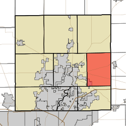 Location in Hamilton County | |
| Coordinates: 40°03′23″N 85°54′30″W / 40.05639°N 85.90833°WCoordinates: 40°03′23″N 85°54′30″W / 40.05639°N 85.90833°W | |
| Country | United States |
| State | Indiana |
| County | Hamilton |
| Government | |
| • Type | Indiana township |
| Area | |
| • Total | 35.13 sq mi (91.0 km2) |
| • Land | 35.09 sq mi (90.9 km2) |
| • Water | 0.04 sq mi (0.1 km2) 0.11% |
| Elevation | 823 ft (251 m) |
| Population (2010) | |
| • Total | 7,886 |
| • Density | 224.8/sq mi (86.8/km2) |
| GNIS feature ID | 0454030 |
Wayne Township is one of nine townships in Hamilton County, Indiana, United States and serves as one of two townships within Noblesville, Indiana's jurisdiction. As of the 2010 census, its population was 7,886 and it contained 3,252 housing units,[1] an increase from 2415 in 2000, as Noblesville continues to expand eastward and Fishers reaches its northern limits. In 2007, Noblesville officially opened one of the largest mixed use developments in the state, called the Noblesville Corporate Campus. A portion of the development is located within the township. When completed, it will include a large industrial/commercial park, several housing developments, hotels, greenspace and a large outdoor shopping center called Hamilton Town Center, being built by the Simon Property Group, headquartered in nearby Indianapolis.
Hamilton Southeastern Schools serve Wayne Township.
History
Wayne Township was organized in 1833.[2]
Geography
According to the 2010 census, the township has a total area of 35.13 square miles (91.0 km2), of which 35.09 square miles (90.9 km2) (or 99.89%) is land and 0.04 square miles (0.10 km2) (or 0.11%) is water.[1] The streams of Gwinn Ditch, Lock Ditch, Mud Creek, Sand Creek, Stony Creek, and William Lehr Ditch run through this township.
Cities and towns
- Noblesville (east edge)
Unincorporated towns
- Clarksville
- Durbin
(This list is based on USGS data and may include former settlements.)
Adjacent townships
- White River Township (north)
- Jackson Township, Madison County (northeast)
- Stony Creek Township, Madison County (east)
- Green Township, Madison County (southeast)
- Fall Creek Township (south)
- Noblesville Township (west)
Cemeteries
The township contains five cemeteries: Bethel, Ervin, Prairie Baptist, Stern and Stony Creek.
Major highways
References
- 1 2 "Population, Housing Units, Area, and Density: 2010 - County -- County Subdivision and Place -- 2010 Census Summary File 1". United States Census. Retrieved 2013-05-10.
- ↑ Haines, John F. (1915). History of Hamilton County, Indiana: Her People, Industries And Institutions, Volume 1. B.F. Bowen & Co. p. 184.
External links
Municipalities and communities of Hamilton County, Indiana, United States | ||
|---|---|---|
| Cities | ||
| Towns | ||
| Townships | ||
| Unincorporated communities |
| |
| Footnotes | ‡This populated place also has portions in an adjacent county or counties | |