Wayah Bald
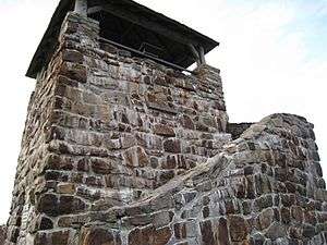
Wayah Bald is a high-altitude treeless open area in Nantahala National Forest, near Franklin, North Carolina. The Wayah Bald Observation Tower is located at the area's highest point (5,385 feet); the stone observation tower was built by the Civilian Conservation Corps in 1937 for fire detection.[1] The Appalachian Trail and Bartram Trail cross at Wayah Bald.
Wayah Bald is a popular destination for hikers, especially during Spring, when the rhododendron and azaleas are in bloom.
History
Wayah Bald received its name from the Cherokee natives. It was named "Wa-ya",[2] the Cherokee word for wolf, after the red wolves that once inhabited the area. Spear points found on the bald indicate that indigenous people used the area as hunting grounds more than eleven thousand years ago.[3]
Wayah Bald Ranger Station to be repaired
In 2009, the Forest Service will work to restore the north face of the Tower using about $75,000. The tower's north wall is breaking down and the stones will be removed and new concrete will be used to repair the wall and reset the stones.[4]
References
- ↑ Sherpa Guides | North Carolina | Mountains | Wayah Bald Area
- ↑ http://www.manataka.org/page122.html#ANIMALS
- ↑ http://www.blueridgeheritage.com/NaturalHeritage/NaturalTreasures/Mountains/wayahbald.html
- ↑ McRae, Barbara (31 July 2009). "Wayah Bald landmark to be restored". The Franklin Press. Retrieved 2009-08-16.
Coordinates: 35°10′49.7″N 83°33′38.75″W / 35.180472°N 83.5607639°W