Wax Lake
Wax Lake was a lake in St. Mary Parish, Louisiana that was converted into an outlet channel to divert water from the Atchafalaya River to the Gulf of Mexico.
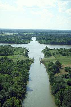
Wax Lake outlet
The Wax Lake outlet is an artificial channel that was created by the United States Army Corps of Engineers in 1942 to divert 30 percent of the flow from the Atchafalaya River to the Gulf of Mexico and reduce flood stages at Morgan City, Louisiana.[1] The project design flood flow capacity for the outlet is 440,000 cu ft/s (12,000 m3/s).[2]
Wax Lake Delta

The Wax Lake Delta is a river delta in Louisiana that was formed by rapid deposition of sediment following the creation of a canal through Wax Lake off of the Atchafalaya River in 1942.[3] It is roughly 20 miles (32 km) southwest of Morgan City[3] adjacent to the Atchafalaya delta.
It receives 34 million tons of sediment per year.[4] In the 64 years between 1941 and 2005, Wax Lake was completely filled with sediment, and the delta prograded approximately 8 km into the sea.[4]
The Wax Lake Delta's distributary channels form via deposition of mouth bars. The first branch to the west is Campground Pass and further south there are the three main branches, East Pass, Greg Pass and Main Pass.[5] The mid-channel is eroded and deposited downstream at the mouth of the river (usually during a period of higher water flow), which will create a new path of flow around it. There is then an added deposition upstream, thus causing the river to bifurcate. This results in the familiar dendritic pattern.
Because it was entirely created during an observable time-period and, other than the creation of the canal, was not altered by humans, it has often been in studies of deltaic formation.[3] In the time since Hurricane Katrina, it has also served and as a model for delta regrowth in the Mississippi River Delta region in order to restore habitat and protect against storm surge.[3][4]
See also
References
- ↑ Davidson, Robert A. (1988). Wax Lake Outlet control structure, Louisiana: hydraulic model investigation. Technical report HL ; 88-23. Vicksburg, Mississippi: US Army Corps of Engineers, Hydraulics Laboratory.
- ↑ "The Mississippi River & Tributaries Project: Designing the Project Flood" (PDF), United States Army Corps of Engineers (PDF), April 2008, retrieved 2011-05-16
- 1 2 3 4 "Wax Lake Delta". National Center for Earth-Surface Dynamics. University of Minnesota. Retrieved 2011-06-01.
- 1 2 3 Pushing Back the Sea
- ↑ Wax Lake outlet passes- Louisianasportsman.com: Retrieved 2016-08-07
Coordinates: 29°35′28″N 91°25′12″W / 29.591°N 91.420°W