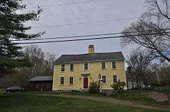
Waterman Tavern
|
Waterman Tavern | |
 | |
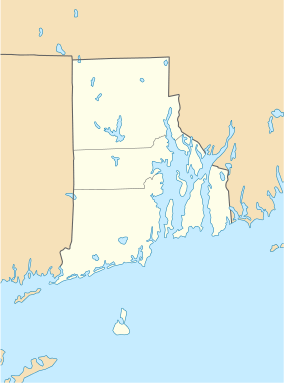  | |
| Location | 283 Maple Valley Rd., Coventry, Rhode Island |
|---|---|
| Coordinates | 41°43′10″N 71°39′37″W / 41.71944°N 71.66028°WCoordinates: 41°43′10″N 71°39′37″W / 41.71944°N 71.66028°W |
| Area | 3 acres (1.2 ha) |
| Built | 1744 |
| NRHP Reference # | 74000040[1] |
| Added to NRHP | July 24, 1974 |
The Waterman Tavern is a historic house and tavern at 283 Maple Valley Road, near Whaley's Hollow in Coventry, Rhode Island. The 2-1/2 story wood frame house, five bays wide with a central chimney, was built sometime before 1747 by John Waterman, who in that year was licensed to operate a tavern on the premises. The site was advantageously located on what was then the main road between Providence and Plainfield, Connecticut. The tavern was a center of civic discourse, and town meetings were regularly held there until 1835.[2]
The tavern is also notable as being one of the first stops along the march route of the Count de Rochambeau's army during its march from Providence to Yorktown, Virginia in 1781, during the American Revolutionary War. The main army camped near the tavern, while the officers were quartered in the tavern itself.[2]
The building was listed on the National Register of Historic Places in 1974.[1]
See also
- March Route of Rochambeau's army
- List of historic sites preserved along Rochambeau's route
- National Register of Historic Places listings in Kent County, Rhode Island
References
- 1 2 National Park Service (2009-03-13). "National Register Information System". National Register of Historic Places. National Park Service.
- 1 2 "NRHP nomination for Waterman Tavern" (PDF). Rhode Island Preservation. Retrieved 2014-07-31.
| Topics | |
|---|---|
| Lists by states |
|
| Lists by insular areas | |
| Lists by associated states | |
| Other areas | |
| |