Washoe Valley, Nevada
| Washoe Valley, Nevada | |
|---|---|
| Census-designated place | |
 Washoe Valley Location of Washoe Valley, Nevada | |
| Coordinates: 39°17′46″N 119°46′34″W / 39.29611°N 119.77611°WCoordinates: 39°17′46″N 119°46′34″W / 39.29611°N 119.77611°W | |
| Country | United States |
| State | Nevada |
| Area | |
| • Total | 5.1 sq mi (13.1 km2) |
| • Land | 5.1 sq mi (13.1 km2) |
| • Water | 0.0 sq mi (0.0 km2) |
| Elevation | 5,096 ft (1,553 m) |
| Population (2010) | |
| • Total | 3,019 |
| • Density | 600/sq mi (230/km2) |
| Time zone | Pacific (PST) (UTC-8) |
| • Summer (DST) | PDT (UTC-7) |
| ZIP code | 89701, 89704 |
| Area code(s) | 775 |
| FIPS code | 32-82250 |
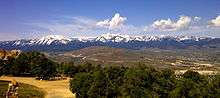
Washoe Valley is a census-designated place (CDP) in Washoe County, Nevada, United States. It corresponds closely to the unincorporated community of New Washoe City. The population was 3,019 at the 2010 census.[1] It is part of the Reno–Sparks Metropolitan Statistical Area. The CDP takes its name from the Washoe Valley, a region between Reno and Carson City centered on Washoe Lake.
Geography
The Washoe Valley CDP is located at 39°17′46″N 119°46′33″W / 39.29611°N 119.77583°W (39.2963, -119.7760), to the east of Washoe Lake. Eastlake Boulevard is the main road through the community, leading both north and south to U.S. Route 395, the main highway through the valley.
According to the United States Census Bureau, the CDP has a total area of 5.1 square miles (13.1 km2), all land.[1]
Demographics
As of the census of 2010, there were 3,019 people, 1,249 households, and 868 families residing in the CDP. The population density was 592.0 people per square mile (230.5/km²). There were 1,311 housing units at an average density of 257.1 per square mile (100.1/km²). The racial makeup of the CDP was 93.6% White, 0.5% African American, 0.9% Native American, 0.9% Asian, 0.1% Native Hawaiian or Other Pacific Islander, 1.5% some other race, and 2.6% from two or more races. Hispanic or Latino of any race were 5.1% of the population.[2]
There were 1,249 households, out of which 25.1% had children under the age of 18 living with them, 58.4% were headed by married couples living together, 7.6% had a female householder with no husband present, and 30.5% were non-families. 22.6% of all households were made up of individuals, and 7.3% were someone living alone who was 65 years of age or older. The average household size was 2.42, and the average family size was 2.84.[2]
In the CDP the population was spread out with 18.1% under the age of 18, 5.3% from 18 to 24, 18.3% from 25 to 44, 43.2% from 45 to 64, and 15.4% who were 65 years of age or older. The median age was 50.0 years. For every 100 females there were 96.9 males. For every 100 females age 18 and over, there were 97.4 males.[2]
For the period 2007-2011, the estimated median annual income for a household in the CDP was $75,323, and the median income for a family was $85,375. Male full-time workers had a median income of $58,889 versus $36,083 for females. The per capita income for the CDP was $33,186. About 3.7% of families and 6.2% of the population were below the poverty line, including 6.4% of those under age 18 and 3.1% of those age 65 or over.[3]
References
| Wikimedia Commons has media related to Washoe Valley, Nevada. |
- 1 2 "Geographic Identifiers: 2010 Demographic Profile Data (G001): Washoe Valley CDP, Nevada". U.S. Census Bureau, American Factfinder. Retrieved January 17, 2013.
- 1 2 3 "Profile of General Population and Housing Characteristics: 2010 Demographic Profile Data (DP-1): Washoe Valley CDP, Nevada". U.S. Census Bureau, American Factfinder. Retrieved January 17, 2013.
- ↑ "Selected Economic Characteristics: 2007-2011 American Community Survey 5-Year Estimates (DP03): Washoe Valley CDP, Nevada". U.S. Census Bureau, American Factfinder. Retrieved January 17, 2013.
Municipalities and communities of Washoe County, Nevada, United States | ||
|---|---|---|
| Cities | 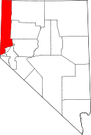 | |
| CDPs | ||
| Unincorporated communities | ||
| Indian reservation | ||
| Indian colony | ||
| Ghost towns | ||