Warrendale, Detroit
Warrendale is a community in far western Detroit, Michigan. It is bordered by Greenfield East Road, Joy Road, and the Detroit city limits. Warrendale neighbors Dearborn on two sides and Dearborn Heights on another side.[1]
History
The community was previously the Village of Warrendale. In the early 1900s the residents voted for annexation so they could become a part of the Detroit water system.[1]
Cityscape
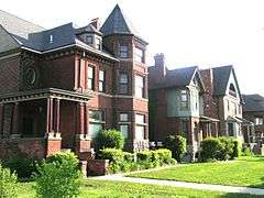
As of 2002 the majority of the houses were built before the 1960s.[2] Most houses in Warrendale, as of 2006, had been constructed in the 1940s. Some houses remaining had been built by the start of the 20th Century. Frank Nemececk of Model D states that the early 20th Century houses "help add to the historic character of Warrendale."[1] Many of the housing consists of one story houses and wood frame bungalows.[2]
Demographics
As of 2002, according to MapInfo Corp., Warrendale had 23,290 residents.[2]
As of 2006, according to the U.S. Census Bureau, the community is 34% White and 34% black. Arab, Asian, Hispanic, and Native American groups make up the remainder.[1]
As of 2005 there is a group of Arab Americans in Warrendale, most of them being Lebanese.[3]
Education
Warrendale is zoned to Detroit Public Schools. Elementary schools within Warrendale serving portions of Warrendale include Ann Arbor Trail, Carver, Dixon, and Gardner. In addition Henderson/Jemison, outside of Warrendale, serves a portion for elementary school.[4] Carver, Dixon, and Henderson/Jemison serve portions of the community for middle school.[5] All residents are zoned to Frank Cody High School, outside of Warrendale.[6]
As of 2013 the approximately 320 students at Gardner belonged to various ethnic groups: about 40% were African-American, another 40% were Middle Eastern, and 10% were Hispanic and Latino. The Middle Eastern students had origins from Iraq, Lebanon, Palestine, and Yemen. The Hispanic students originated from Mexico, the Dominican Republic, and Venezuela. Some students at Gardner originated from Nigeria.[7]
Warrendale Charter Academy, a charter school operated by National Heritage Academies, is in Warrendale.[8] Prior to the opening of the charter school, the Saints Peter and Paul Catholic School of the Roman Catholic Archdiocese of Detroit occupied the building.[9]
History of schools
The Detroit Public Schools school board closed Leslie Elementary School in Warrendale in 1985. In 1992 the Detroit Board of Education voted to move Malcolm X Academy, an "African-centered" curriculum school, into the former Leslie school.[10] Malcolm X had 470 students, one of whom was white. The move prompted a protest from the community, which at the time was a majority White working class community.[11] At the time the nearest elementary school in the immediate area, George Washington Carver Elementary School, was overcrowded.[12]
Warrendale residents objected to the idea that the Detroit Public Schools would divert funds and basic services to the Malcolm X Academy, which would be a mostly middle class school, and argued that the board should instead focus on its own overcrowded local school. Marc Christensen of the Metro Times said that the controversy lead outsiders to brand Warrendale as a racist area "because of their unprofessional speech, and because they couldn’t control how other people thought the "whiteness" of their neighborhood mattered."[13] He explained that the scenario therefore became "a nightmare."[13] John Hartigan, Jr. wrote about the controversy in one chapter of his book Racial Situations: Class Predicaments of Whiteness in Detroit, published by Princeton University Press.[13] Police officers escorted the Malcolm X students to school due to perceived dangers.[14]
Other zoned elementary schools previously serving Warrendale include Kosciuscko Elementary School,[15] Lessenger K-8, and the standalone Jemison Elementary School.[16] Zoned middle schools previously serving Warrendale include Lessenger Middle School and Ruddiman Middle School;[17] Lessenger later became Lessenger K-8.[18]
Parks and recreation
The 1,181-acre (478 ha) Rouge Park is in Warrendale. It is twice the size of Belle Isle.[1]
References
- Hartigan, John, Jr. Racial Situations: Class Predicaments of Whiteness in Detroit. Princeton University Press, 1999. ISBN 0691028850, 9780691028859.
Notes
- 1 2 3 4 5 Nemececk, Frank. "Warrendale's Understated Cool." Model D. Tuesday May 9, 2006. Retrieved on November 20, 2012.
- 1 2 3 Patterson, Brendel. "WHERE WE LIVE WARRENDALE IN WESTERN DETROIT." Detroit Free Press. July 5, 2002. F1 Real Estate. Retrieved on November 20, 2012. "House styles are mostly wood-frame bungalows and one-story houses, under 1,000 square feet with two or three bedrooms, built before the 1960s. According to MapInfo Corp., the total population is 23,290. "
- ↑ Hassoun, Rosina J. Arab Americans in Michigan (Discovering the Peoples of Michigan). MSU Press, October 24, 2005. ISBN 1609170466, 9781609170462. p. PT21 of Google Books.
- ↑ "Elementary Boundaries - 2012/13 School Year." (Archive) Detroit Public Schools. Retrieved on November 20, 2012.
- ↑ "Middle School Boundaries - 2012/13 School Year." (Archive) Detroit Public Schools. Retrieved on November 20, 2012.
- ↑ "High School Boundaries - 2012/13 School Year." (Archive) Detroit Public Schools. Retrieved on November 20, 2012.
- ↑ "School of the Week: Gardner Elementary School, where students learn to share a warm, welcoming “Hello” in 21 languages (Archive). Detroit Public Schools. Retrieved on November 23, 2015.
- ↑ "Home." Warrendale Charter Academy. Retrieved on November 20, 2012. "19400 Sawyer Street Detroit, MI 48228"
- ↑ Walsh-Sarnecki, Peggy. "CHARTER SCHOOLS GROWING DATA SHOW STUDENTS ARE SHIFTING AWAY FROM DETROIT DISTRICT." Detroit Free Press. September 10, 2002. B1 NWS. Retrieved on November 20, 2012. "Ss. Peter and Paul Catholic School before it closed and Warrendale moved into the building."
- ↑ Hartigan, p. 209.
- ↑ "Hostility Greets Students at Black School in White Area of Detroit." The New York Times. December 2, 1992. Retrieved on November 20, 2012.
- ↑ Hartigan, p. 210.
- 1 2 3 Christensen, Marc. "White thought, black thought." Metro Times. May 17, 2000. Retrieved on November 20, 2012.
- ↑ "Detroit Police Escort Schoolkids." Chicago Sun-Times. September 29, 1992. Retrieved on November 20, 2012.
- ↑ "Elementary School Attendance Areas." Detroit Public Schools. July 10, 2003. Retrieved on November 20, 2012.
- ↑ "Elementary School Boundary Map." Detroit Public Schools. Retrieved October 20, 2009.
- ↑ "Middle School Attendance Areas." Detroit Public Schools. July 10, 2003. Retrieved on November 2, 2012.
- ↑ "Middle School Boundary Map." Detroit Public Schools. Retrieved October 20, 2009.
Further reading
- Angel, Cecil. "POLICE RAID TEENAGE NIGHTCLUB PATRONS FACE CHARGES; WARRENDALE QUIETER." Detroit Free Press. June 28, 1999. B6.
- Hartigan, John Jr. "'White Devils' Talk Back." In: Rasmussen, Birgit Brander, Eric Klinenberg, Irene J. Nexica, and Matt Wray (editors). The Making and Unmaking of Whiteness. Duke University Press, August 17, 2001. start page 138. ISBN 0822327406, 9780822327400.
External links
- Kiska, Tim. "WHERE WE LIVE: WARRENDALE, WAYNE COUNTY." Detroit Free Press. January 7, 2005. G1 Real Estate.
- Warrendale Charter Academy
Coordinates: 42°20′49″N 83°13′39″W / 42.3469°N 83.2275°W