Warner Valley, California
| Warner Valley | |
|---|---|
| census-designated place | |
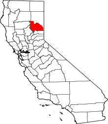
 Warner Valley Position in California. | |
| Coordinates: 39°46′48″N 120°32′28″W / 39.78000°N 120.54111°WCoordinates: 39°46′48″N 120°32′28″W / 39.78000°N 120.54111°W | |
| Country |
|
| State |
|
| County | Plumas |
| Area[1] | |
| • Total | 17.526 sq mi (45.392 km2) |
| • Land | 17.497 sq mi (45.317 km2) |
| • Water | 0.029 sq mi (0.075 km2) 0.17% |
| Elevation[2] | 6,509 ft (1,984 m) |
| Population (2010) | |
| • Total | 2 |
| • Density | 0.11/sq mi (0.044/km2) |
| Time zone | Pacific (PST) (UTC-8) |
| • Summer (DST) | PDT (UTC-7) |
| GNIS feature ID | 2583182 |
| U.S. Geological Survey Geographic Names Information System: Warner Valley, California | |
Warner Valley is a census-designated place in Plumas County, California. Warner Valley sits at an elevation of 5,341 feet (1,628 m). The 2010 United States census reported Warner Valley's population was 2.
Geography
According to the United States Census Bureau, the CDP covers an area of 17.5 square miles (45.4 km²), 99.83% of it land and 0.17% of it water.
Demographics
The 2010 United States Census reported that Warner Valley had a population of 2. The racial makeup of Warner Valley was 2 (100.0%) White. Hispanic or Latino of any race were 0 persons (0.0%).[3]
References
This article is issued from Wikipedia - version of the 11/3/2013. The text is available under the Creative Commons Attribution/Share Alike but additional terms may apply for the media files.