Wansford, East Riding of Yorkshire

Coordinates: 53°59′35″N 0°22′53″W / 53.993089°N 0.381286°W
Wansford is a village in the East Riding of Yorkshire, England; it forms part of the civil parish of Skerne and Wansford. It is situated on the B1249 road and just to the north of the River Hull and the Driffield Canal. It is approximately 2.5 miles (4 km) south-east of Driffield and 3 miles (4.8 km) north-west of North Frodingham.
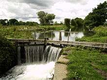
A lock gate on the Driffield Canal at Wansford
The church of St Mary the Virgin, Wansford was built in 1866–68 to designs by G.E. Street. It is on the Sykes Churches Trail devised by the East Yorkshire Churches Group.[1] The church was designated a Grade II* listed building in 1966 and is now recorded in the National Heritage List for England, maintained by Historic England.[2]
References
- ↑ "Sykes Churches Trail Southern Route". Beverley, East Yorkshire: East Yorkshire Historic Churches Group.
- ↑ Historic England. "Church of St Mary the Virgin (1162211)". National Heritage List for England. Retrieved 16 August 2013.
- Gazetteer — A–Z of Towns Villages and Hamlets. East Riding of Yorkshire Council. 2006. p. 11.
| Wikimedia Commons has media related to Wansford. |
This article is issued from Wikipedia - version of the 1/24/2016. The text is available under the Creative Commons Attribution/Share Alike but additional terms may apply for the media files.