Wangaloa

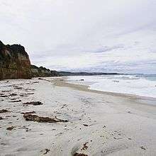
Wangaloa is a small coastal settlement in South Otago, New Zealand. It is located to the north of the mouths of the Clutha River the beach area, close to the town of Kaitangata. There is access to Wangaloa Beach from the Kaitangata Golf course. Wangaloa is connected to Toko Mouth, 10 kilometres (6.2 mi) to the north, by a coastal road, and to Kaitangata, 5 kilometres (3.1 mi) to the west, by a road which crests a low range of coastal hills.[1]
The name of Wangaloa is from the southern dialect of Māori, and means long bay (equivalent to Whangaroa in standard Māori).[2]
Wangaloa was home to an open cast coal mine which operated as part of the Kaitangata coal field from 1945 to 1989. The area surrounding the former mine is being extensively re-landscaped as a recreational reserve.[3]
References
- ↑ Reed New Zealand atlas (2004) Auckland: Reed Publishing. Map 111. ISBN 0 7900 0952 8
- ↑ Wise's New Zealand guide (1969) Dunedin: H. Wise & Co. p. 401
- ↑ Davidson, Richard (13 April 2015). "Wangaloa Mine to open this weekend". The Southland Times. Retrieved 3 July 2016.
External links
- The Archaeology and European History of the Wangaloa Block (PDF)
- Wangaloa Mine Restoration
- Kaitangata Golf Club
- Geoview.info Wangaloa
Coordinates: 46°16′45″S 169°55′45″E / 46.27917°S 169.92917°E
| Wikimedia Commons has media related to Kaitangata. |