Wandiligong
| Wandiligong Victoria | |
|---|---|
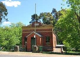 Manchester Unity hall | |
 Wandiligong | |
| Coordinates | 36°45′41″S 146°59′3″E / 36.76139°S 146.98417°ECoordinates: 36°45′41″S 146°59′3″E / 36.76139°S 146.98417°E |
| Population | 296 (2011 census)[1] |
| Postcode(s) | 3744 |
| Location |
|
| LGA(s) | Alpine Shire |
| State electorate(s) | Ovens Valley |
| Federal Division(s) | Indi |
Wandiligong is a town in north-eastern Victoria, Australia. The town is located on Morses Creek and in the Alpine Shire local government area, 6 kilometres (3.7 mi) south of Bright and 330 kilometres (210 mi) north east of the state capital, Melbourne. At the 2011 census, Wandiligong had a population of 296.[1]
Wandiliong was established in the 1850s during the Victorian gold rush and at one stage the town was home to 2,000 people. The town as a whole is now registered with the National Trust of Australia as a historic landscape and is home to building with historic value such as the Manchester Unity hall—built in 1874.[2]
The town is home to one of the largest apple orchards in the southern hemisphere.[3]
References
- 1 2 Australian Bureau of Statistics (31 October 2012). "Wandiligong (State Suburb)". 2011 Census QuickStats. Retrieved 2 December 2014.
- ↑ "Wandiligong information and attractions". Travel Victoria. Retrieved 16 May 2010.
- ↑ "Travel: Bright". Sydney Morning Herald. Fairfax. 6 November 2007. Retrieved 16 May 2010.
External links
![]() Media related to Wandiligong, Victoria at Wikimedia Commons
Media related to Wandiligong, Victoria at Wikimedia Commons